
Last updated January 2024 | Words and photos by Joshua Zukas | Edited by Tom Divers | 575 comments

Joshua is a contributing writer for Vietnam Coracle. A freelancer whose body of work focuses primarily on travel & architecture, Joshua covers Vietnam regularly for Lonely Planet, Michelin Guide, Insider, Ink Global & many of Asia’s top inflight magazines. He also writes intermittently for publications such as The Economist, Wallpaper & Interior Design Magazine. He holds an MSc in sustainable tourism….read more about Joshua
Hà Giang is Vietnam’s northernmost province. Once considered the final frontier for adventurous travel in Vietnam, this borderland has since gained legendary status among independent travellers, principally for a motorbiking itinerary through otherworldly landscapes, known as the Hà Giang Loop. Main roads meander past rippling rice terraces, mountain passes cut cliff faces above turquoise rivers and countryside lanes thread through forests of limestone pinnacles. Hà Giang is also home to more than a dozen ethnolinguistic groups, each with their own language, architecture, apparel and way of life. In recent years, visitor numbers on the Hà Giang Loop have increased, road conditions have improved and tourist services have proliferated. While some road sections can get busy with motorbike convoys, mass tourism has not arrived….yet. Now is the time to ride the Hà Giang Extreme North Loop.

[Back Top]
HA GIANG LOOP: MOTORBIKE GUIDE
Riding the Legendary Landscapes of Vietnam’s Extreme North
This guide is intended for independent motorbikers, but it should also be useful for cyclists, motorists and any travellers trying to design a tour of the Hà Giang Loop with a driver or company. My route map features the main loop and several side routes and extensions. In the Overview & Details section, you’ll find useful, need-to-know information, such as weather, motorbike rental, duration and distance, accommodation, food and drink, police and permits, as well as a general outline of the route. For each section of the Hà Giang Loop, I’ve written a detailed description, including recommendations of places to stay and eat, sights and excursions along the way, and much more. There’s a separate section for Hà Giang City, as this is where most travellers will start and end their trip:

CONTENTS:
Section 1: Hà Giang→Tam Sơn
Section 2: Tam Sơn→Yên Minh
Section 3: Yên Minh→Lũng Cú
Section 4: Lũng Cú→Đồng Văn
Section 5: Đồng Văn→Mèo Vạc
Section 6a/6b: Mèo Vạc→Mậu Duệ/Bảo Lạc
Section 7: Mậu Duệ→Du Gìa
Section 8: Du Gìa→Hà Giang

Support My Work
Free | Independent | No Sponsored Content
“Hello, if you enjoy my website, please support it.
Thank you.” Tom

ROUTE MAP:
Hà Giang Loop: The Extreme North by Motorbike
Blue Line: main loop | Red Lines: side routes
*Road Safety & Disclaimer: Riding a motorbike in Vietnam – or anywhere in the world – has its dangers. I would hope & expect anyone who chooses to pursue a self-drive road trip based on the information on this website does so with care, respect & due diligence. I encourage careful riding & adherence to road rules, but I am not responsible for the legality or manner in which you ride, nor any negative consequences which may result from your decision to ride a motorbike in Vietnam: you do so at your own risk. Read more >
Overview & Details:
Below is a quick overview of the Hà Giang Loop with links to each section of the route, followed by useful information and important considerations for travellers, such as motorbike rental, weather, duration, police, connecting routes and more:
QUICK DETAILS:
- Route: Hà Giang→Tam Sơn→Yên Minh→Lũng Cú→Đồng Văn→Mèo Vạc→Mậu Duệ→Du Già→Hà Giang
- Distance: 384km (main loop)
- Duration: 3-10 days (main loop, side routes, extensions)
- Scenery: limestone karsts, deep gorges, remote borderlands, waterfalls, villages
- Attractions: dramatic landscapes, mountain passes, good riding, historic buildings, homestays, waterfalls, hiking, boat trips
- Road Conditions: very mountainous paved roads, some rough sections, mostly light traffic, some busy sections
- Best Time: March-May, September-November
SECTIONS:
- Section 1: Hà Giang→Tam Sơn | 52km
- Section 2: Tam Sơn→Yên Minh | 36km or 53km
- Section 3: Yên Minh→Lũng Cú | 57km
- Section 4: Lũng Cú→Đồng Văn | 26km
- Section 5: Đồng Văn→Mèo Vạc | 23km
- Section 6a/6b: Mèo Vạc→Mậu Duệ/Mèo Vạc→Bảo Lạc | 37km/73km
- Section 7: Mậu Duệ→Du Già | 38km
- Section 8: Du Già→Hà Giang | 98km
ABOUT THE LOOP:
Main Loop & Side Routes: The main route (the blue line) is a loop, but I have also included several scenic side trips, alternative routes and extensions (the red lines). [View Map]
Distance: The main loop is 384km. However, if you add any of the side routes and extensions (which you definitely should), the total distance will increase accordingly.
Duration: I’ve divided the loop into 8 sections, each of which represents a leg between major towns on the route. The sections do not indicate full days or even half-days on the road. Most riders will likely cover up to 3 sections in one day. A minimum of 3 days is required to ride the main loop. But you could easily spend a week or two exploring the side routes in addition to the main loop. An ideal time-frame to really enjoy the loop and get the most out of the region is 4-7 days.

Connecting Routes: Although most travellers start and end in Hà Giang City, there are many options to forgo the loop by connecting with other great routes to the east, west and south of Hà Giang. One option is to continue southeast from Mèo Vạc down to Bảo Lạc in Cao Bằng Province (Section 6b), from where you can connect with one of the Northeast Loops & Routes. Another alternative is to connect to the Borders & Back-Roads route west of Hà Giang City. South of Hà Giang, there’s the Tuyên Quang Magic 8 Loop and the Trans-Northern Belt Road. (For links to more motorbike guides in the region see Related Routes.)
Weather & Time of Year: Conditions are best from March-May and September-November, when the weather is warm and clear, colours are bright, and rainfall is light. It can get bitterly cold during the winter (December-February) and there is heavy rainfall in the summer (June-August). However, such is the majesty of Hà Giang, that even when weather conditions aren’t ideal, most riders still enjoy the loop.
Road conditions: Although most of the roads are now in pretty good condition, there are still some sections that are rough, under repairs, or suffer from regular landslides. I’ve included warnings of rough roads throughout this guide and on my map. In addition, readers can check the comments section for any recent updates.
Motorbike Rental & Tours: There are lots of motorbike rental outlets in Hà Giang City, almost all of which are on the east side of the river on Nguyễn Thái Học Street and the blocks behind. Try to find a place with a printed price list (usually by the day), good helmets and staff that speak some English. You’ll need to leave some form of identification as deposit, but resist leaving your passport as you’ll need it for the journey. If there are no other options, take photos and/or photocopies. Some recommendations are Ngân Hà Travel, Kiki’s House, Style Motorbikes, and QT Motorbikes. It’s usually not necessary to book your bike in advance, unless you’re travelling during a public holiday. If the rental place doesn’t have the bike you want, simply move on to the next one. At the time of research, rental was 150,000vnd-500,000vnd per day depending on the bike model. Flipside Adventures runs bespoke tours that specialise in off road adventures. There are many other tour agencies: Jasmine and Mama’s are both recommended.
Police, Permits & Fees: At the time of research, police permits to travel in northern Hà Giang were not required. However, local authorities were in the process of implementing a daily entrance fee for visitors to the Đồng Văn Geopark (i.e. the northernmost sections of the loop). Details were still being finalised, but accommodations will likely be responsible for charging this fee to visitors and it will be between $2-$10 per day. Riding a motorbike in Hà Giang without a local or international driving licence is illegal, as it is in the rest of Vietnam. There are an increasing number of regularly changing police checkpoints throughout the loop, and they will demand to see a licence. Negotiating these situations is up to the rider, but should always be conducted with patience, politeness and understanding. Ask your motorbike rental for more information about licences and police checks before you set off.
Accommodation: All towns on the loop now have a decent range of overnight options, including hotels, mini-resorts, boutiques, guest houses, hostels and, best of all, homestays. The latter are not just located in the towns; they’re dotted all around the countryside. In most cases, you can just turn up and find a bed, even at busy times (although that’s not always the case with food: see below). In this guide, I’ve included recommendations of places to stay in each section of the loop.
Food & Drink: If you want to stay in a homestay and you want to eat well, try to book at least one day in advance and tell them you want dinner. With Google chat, Facebook and Instagram, this has become easier than ever, even if you don’t speak a word of Vietnamese. If you don’t tell them you’re coming ahead of time, then you may have to settle for instant noodles for dinner. In the towns, there’s plenty of food available at mealtimes. I’ve included recommendations of places to eat in each section of this guide.
Sights & Activities: As well as the riding, there’s a lot to see and do on the Hà Giang Loop. In my guide, I’ve included recommendations of sights and excursions along the way. These include historic buildings, hikes, viewpoints, waterfalls, gorges, villages, and much more. On the road, look out for the dozens of informative plaques, which give details about nearby areas of interest.


Hà Giang City:
Accommodation, Dining, Sights & Attractions in the Provincial Capital
[View Map]
Hà Giang, the provincial capital, is a likeable city on the banks of the Lô (Blue) River which, despite its name, usually runs muddy and brown. It’s a comfortable place to prepare for the loop and relax and recuperate after the ride. There are a lot of good accommodation options near the two main streets on both sides of the river: Nguyễn Trãi Street on the west bank and Nguyễn Thái Học Street on the east bank. For peace and quiet, there is a cluster of hotels in the neighbourhood immediately north of the central square (Quảng Trường Thành Phố Hà Giang), such as the very comfortable Luxury Hostel (it isn’t luxury or a hostel, but simply a well-run and good value guesthouse). Overlooking the square are Mị Homestay and Nhật Bảo Hotel, which offer views of the square but are noisy on weekends. There’s more choice on the other side of the river, such as the cheap and cheerful Tiamo and the Sky Building, which has a bizarre but comfortable café-cum-hostel overlooking the river. For something a little more upmarket, try Hà Giang Historic House or Phoenix Hotel. There’s also a cluster of hotels and homestays immediately south of the bus station, which feels like the countryside even though it’s a few minutes’ drive from the city. The two private rooms at Homestay Field are highly recommended, and the charismatic owner can put together delicious dinners at a moment’s notice. Two well-run accommodation options north of town are NoMadders and Flipside Adventures.
When it comes to food, you’re spoilt for choice (at least compared with the rest of the province). For breakfast, the bánh cuốn (wet savoury pancakes) at Bánh Cuốn Quảng Trường Hà Giang may be the best in town. Just around the corner on Nguyễn Trãi Street is a handful of decent phở restaurants. For lunch or dinner, try the restaurants overlooking the central square or in the neighbourhood south of it close to Luxury Hostel. There are also many eating options along Nguyễn Thái Học Street, including a beer bar (Nhà Hàng Phố Beer), an upmarket restaurant (Bếp Việt) and surprisingly good pizza (Pizza Here). For vegans and vegetarians, there’s Hương Sen. You’ll find good Vietnamese coffee (and not so good Western coffee) at Trung Nguyên and Lofita. For a drink with a view, ride up to Cafe Núi Cấm, which is also the starting point for the climb to the viewpoint (see below). A good place to buy supplies for snacks and picnics on the road is Ha Giàng’s big central market.
You might hear that there’s nothing to do in Hà Giang City. This is nonsense. Strolling the central square (Quảng Trường Thành Phố Hà Giang) and around, visiting the provincial museum, and climbing up to explore the city’s French fort and viewpoint will easily fill an afternoon.


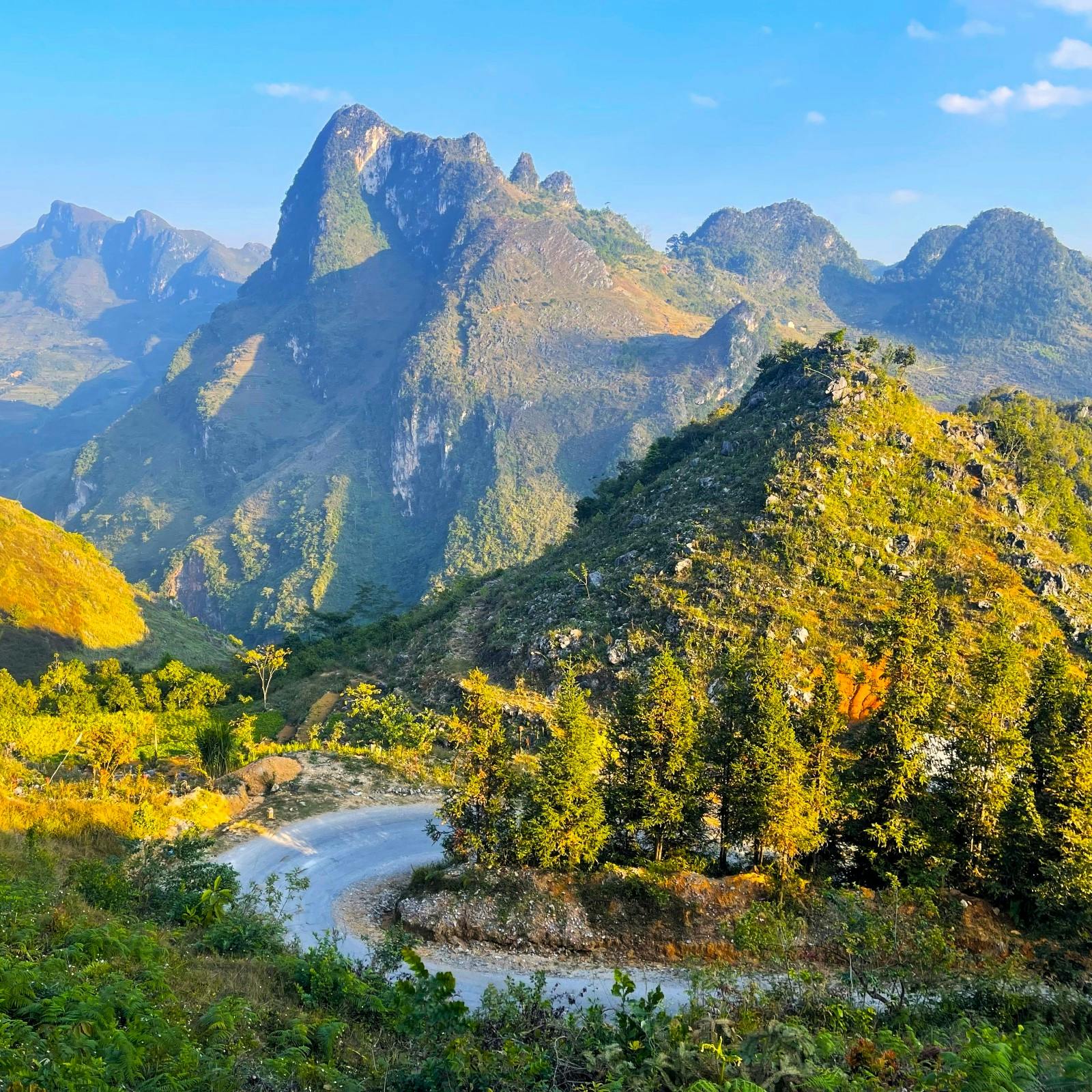
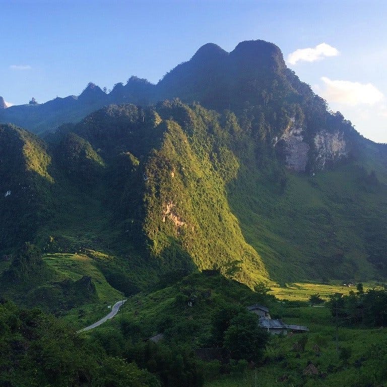
Section 1:
Hà Giang→Tam Sơn | 52km
[View Map]
Take Road QL4C north out of Ha Giàng towards Tam Sơn. It’s only a few kilometres before forested limestone mountains tower over you and pretty blue rivers (depending on the season) run alongside the road. The real drama begins after about 30km, at which point you’ll see a sign for Tham Luồng Cave, which is worth a stop if you’re taking it slow and you’ve not seen a limestone cave before. (Note that this stop will add about an hour to your journey and involves climbing a lot of stairs.)
Ride up Bắc Sum Pass, which offers fabulous views back in the direction of Hà Giang City, until the road levels out and you reach Bình An Linh Từ Shrine, dramatically situated on a hill and an excuse to stretch your legs. Continue past a rare example of a Bố Y homestay (the Bố Y ethnolinguistic group only have a few thousand members in Vietnam) before the road begins a long, snaking ascent up to Heaven’s Gate Pass.
After crossing a treeless plateau, Heaven’s Gate Pass drops down to the town of Tam Sơn, nestled in a valley between dozens of conical hills. Near the top of the pass there’s a viewing point with a coffee shop and a few maps of the area. Climb the steps behind the cafe to a small gazebo for unobscured views of the entire district. Ride a little further to view the so-called “Fairy Bosoms”, which have become an iconic symbol of the province for Vietnamese tourists.
Despite its scenic location, the town of Tam Sơn (known locally by the district name Quản Bạ) is a fairly prosaic place. Most people simply stop for some lunch at the popular Yến Ngọc Cafe before continuing on the road. Should you feel like stopping for the night, head to the Dào village of Nặm Đăm, where there are now tens of homestays. This is also where you’ll find Dào Lodge, a boutique guesthouse, but it’s been poorly managed for years. The guesthouse was built by 112 Architects, a Hanoi-based firm that draws inspiration from indigenous architecture to design modern buildings. Instead of staying overnight here, order a coffee and enjoy the architecture from the courtyard.


Section 2:
Tam Sơn→Yên Minh | 36km/53km
[View Map]
From Tam Sơn, continue on Road QL4C east down to the Miện River valley. At the end of a series of switchbacks (affording yet more stunning views), the road crosses the river on the Cán Tỷ bridge and then you have a decision to make: either stay on QL4C (the blue line) heading due north for the quieter, longer route, passing more hamlets, Cán Tỷ Fort, a pine forest and views of rice terraces; or bear right (due east) just after the bridge for the busier, shorter and more dramatic route (the red line), climbing immediately, passing an ancient tree and some excellent viewpoints. Which road is better? It’s hard to say. Perhaps take the longer road (QL4C) in the spring and summer months when the rice terraces are green and bulging, but take the shorter route in the autumn and winter months when the landscapes are starker.
Whichever route you take, when you descend into Yên Minh you’ll see the limestone forests of the Đồng Văn Plateau in the distance, looking like the crenulated ramparts of a giant castle. Yên Minh is another small, dusty town in a basin surrounded by great limestone pillars. Although it’s not a particularly charming place to stay, it’s a convenient stop and the main street has a few hotels to choose from. Try Bống Bang Homestay 2, which also serves up delicious food in their leafy garden away from the road.


Section 3:
Yên Minh→Lũng Cú | 57km
[View Map]
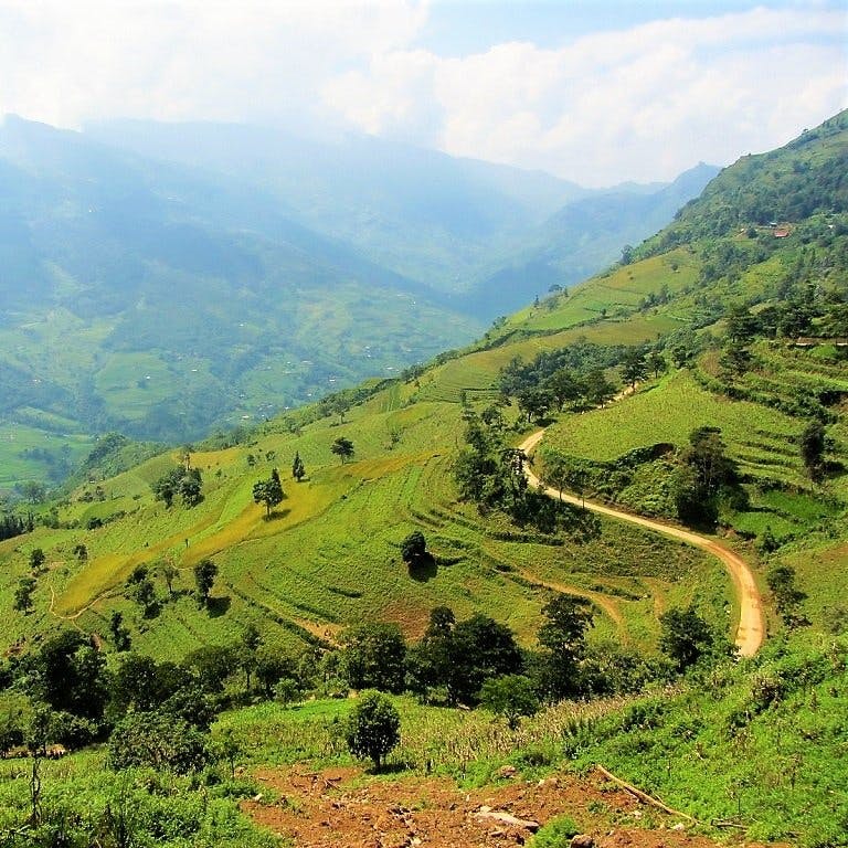
The scenery gets even better north of Yên Minh. Road QL4C ploughs through an undulating landscape of dramatic peaks and troughs, formed over millions of years by tectonic activity and erosion. Pinnacles rise and fall at regular intervals, and the shapes are so live and animated, it’s as if the landscape were in fluid motion until it was suddenly petrified, like a frozen sea. The roads that cut through the terrain are as impressive as the topography. In the last few years, dozens of small, paved lanes have appeared, criss-crossing the entire area. These offer tempting diversions, leading to isolated villages and towns hidden deep within the landscape.
The people who inhabit this region are predominantly mountain dwelling ethnolinguistic groups, particularly Hmông. For them, this rocky, treeless land offers little protection from the elements, and crop yields are limited because of the lack of fertile soil. Travellers who’ve come from Sapa, may find minority people in this region less forthcoming when compared to the business-savvy people in the northwest. However, children all along this route will skip and jump down the road screaming “Hello!” and occasionally put their hands out for money. You might keep some small, nourishing snacks to offer these children as an alternative to money. Children may also pose for photos and then ask for money. This is a dynamic which has made social interactions between foreign visitors and local people in more touristy areas like Sapa increasingly uneasy.
A couple of minutes due east of Yên Minh, the road forks. Bear left (due northeast), continuing on QL4C towards Đồng Văn. A steep pass takes you immediately into the limestone karsts. Trees are noticeably absent from the rocky slopes, and there are no more terraced rice fields and fertile valleys. Instead, you’ll see acres of soybean plantations, punctuated occasionally by clumps of corn. Many older structures are made of mud bricks or blocks cut from the limestone. Walled hamlets shelter in the tight clasp of conical hills.
After cutting along steep, treeless valleys, the road winds up Dốc Thẩm Mã and then the Nine-Turn Pass. A helter-skelter stretch of tarmac, this pass is a favourite photo-opportunity for road-trippers. From the top, you can see the road snaking down to a flat valley encased by limestone karsts. A little further on, a left turn (due north) offers a short side route heading to Phó Bảng, a predominantly ethnic Chinese town. This add-on is well worth the time and effort, especially in October, when the purple, pink and white buckwheat flowers are in bloom. Phó Bảng’s old town is very special, with several terraced houses built in a distinct Chinese style. Otherwise, continue on QL4C past a little Hmông village that receives a constant flow of domestic tourists thanks to being the filming location of the popular 2006 movie Story of Pao. After passing this heavily touristed village, there are opportunities to leave the main road and explore more authentic (less touristy) Hmông hamlets via side roads, such as the one to Lao Sa (also written Lao Xa). Here you’ll find a very special homestay in an ancient Hmông abode.
Back on QL4C heading due east, after more glorious scenery there’s another fork in the road at Sà Phìn. You’ll bear left at the fork (signposted to Lũng Cú and leaving QL4C), but first, continue south for a few hundred metres to visit the former palace of the Hmông king (entrance is a couple of dollars). One of the most compelling heritage sites in the province, this attractive stone and timber structure was built by the French colonial administration to appease the Hmông king. He had a fearsome reputation and considerable wealth, gained from growing opium poppies in the area. The palace’s three stone courtyards and tiled rooftops look like a set from Crouching Tiger, Hidden Dragon. Outside, there’s a local market selling seasonal produce: in the autumn there are walnuts, chestnuts and star anise for sale. The palace is signposted off the main road, down a steep lane leading into the valley.
*Note: If you decide to skip the next part of the route to Lũng Cú, ignore the rest of this section and jump to the second paragraph of Section 4 instead.
Leave the king’s palace and backtrack a little to the fork, then head due north to Lũng Cú, Vietnam’s North Pole. This is a popular pilgrimage for young Vietnamese groups, who make the trip on motorbikes from Hanoi. At the Khe Lia Panorama, continue due north on the Lũng Cú road. After a few kilometres you’ll see signs to the Giấy village of Má Lé, which also has a special homestay in a breath-taking two-floor house made of stone and wood (although the service here is questionable). A fun curiosity of the homestay, which presumably has had funding from UNESCO, is the tiny brachiopods museum, which holds fossils from the area. The museum isn’t impressive or informative, but its perplexing existence in such a remote part of the country is worthy of some admiration. Further on, the road briefly runs parallel to the Chinese border. The border appears fluid and unguarded. Motorbikes cross over to China and back again, passing a sinister milestone with black skull and crossbones next to a few red-painted Chinese characters. Do not attempt to cross the border.
Marking Vietnam’s northernmost point in Lũng Cú is a tall flag tower atop a small hill with excellent views across to China. (Sticklers may wish to note that Vietnam’s true northernmost point is a few kilometres north of the flag tower.) Entrance costs a few dollars and you can pay an extra dollar for an electric buggy to take you most of the way. The village of Lô Lô Chải is close by and has several homestays, some of which are a little like rustic boutique hotels. Lô Lô Paranoma (presumably a misspelling) is family-run, friendly and has an outdoor terrace with unrivalled panoramas/paranomas. Homie Homestay is also friendly with dorm beds and private rooms. Long Cư Homestay (another misspelling?) is more like a hotel with a handful of elevated bungalows. Lô Lô Chải is inhabited by the Lô Lô, a small ethnolinguistic group famed for the quiltlike apparel worn by the women. The village is pretty, but unfortunately it’s hard to know which houses are genuine heritage buildings that exhibit traditional Lô Lô architecture. I’ve been here several times over the years, and each time the village seems to have a new cluster of homestays crammed into its narrow alleyways.


Section 4:
Lũng Cú→Đồng Văn | 26km
[View Map]
The road from Lũng Cú to Đồng Văn is straightforward. Retrace your steps to the Khe Lia Panorama, at which point you’ll head east on DT182B for the rest of the journey. Alternatively, consider heading back west from Khe Lia Panorama to the Hmông kings palace at the junction with QL4C and then rejoin the road east to Đồng Văn (the red line on my map).
From the palace, QL4C heads east along a serpentine 15km road that coils around limestone pylons. The road is chiselled out of the mountains, gripping to the side of rocky cliffs. Various countryside lanes may tempt you to explore further as they meander up from the road before being swallowed by the clouds or hills. All along this road there are women and girls – from as young as 10 to as old as 80 – carrying heavy loads of wood, hay, and crops on their backs. The bodies of the older women have been permanently distorted, so that their backs are almost at right angles to their legs, even when walking unburdened.
Dồng Văn feels dusty and sprawling until you get to its old quarter, which offers some charm despite a row of fake heritage houses that host restaurants, cafes and hotels. Đồng Văn is one of the most popular towns on the loop and there’s a distinctive touristy vibe, but there’s also plenty to see and do. The district museum wasn’t complete at the time of research, but the large building, which you’ll see before you arrive in town, looks promising. Rice terraces and vegetable gardens encircle the attractive Quan Hoàng Temple, which is close to a storied water god shrine. Legend has it that this area was impossible to farm until a god showed Tày settlers (an ethnolinguistic group) the valley’s water source. To thank him, the Tày people built the shrine. Stretch your legs by climbing the Đồn Cao Fortress, which was built by the French at the turn of the 19th century and offers panoramic views.
There’s a clutch of good places to stay and eat in Đồng Văn. Làng Nghiến Homestay and Nhà Cổ Homestay 1925 are two good budget options; the former is cleaner and more practical, the latter is more atmospheric. H’mong Coffee & Motel is a step up and run by an exuberant team of young Hmông. More high-end accommodation options include Đồng Văn Eco Stone House and Đồng Văn Cliffside House. If Đồng Văn’s touristy inclination doesn’t appeal, consider booking a room at Thiên Hương House, a 20-minute drive north of town. Vegetarians and non-vegetarians alike can tuck into carefully prepared Vietnamese food at Toto Chan. There’s also excellent Vietnamese food served with a smile at Ethnic House. For cheap street food served throughout the day, simply wander down the main road west of H’mong Coffee & Motel.


Section 5:
Đồng Văn→Mèo Vạc | 23km
[View Map]
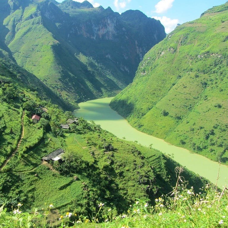
Đồng Văn to Mèo Vạc is a 23km-ride along the Mã Pí Lèng Pass, a staggering road clinging to the edge of a wall of limestone mountains, towering hundreds of feet above the craterous Nho Quế River valley. After a short climb southeast out of Đồng Văn on QL4C, the ground seems to fall away as you’re left gasping at the enormous chasm below. Incredibly, farming continues on the near-vertical slopes below and above the pass. This deep, treeless valley has the acoustics of an amphitheatre: you can hear the voices of children and bleats of goats from way down on the banks of the river echoing around the mountains. There are several viewing platforms on the way to Mèo Vạc where you can find refreshments. About halfway along the pass the twists and turns reveal mesmerizing views over a vast landscape that appears to have no discernible bottom. This is apparently one of the deepest gorges in Southeast Asia. I used to think that this was the most spectacular road in all of Vietnam, but car convoys and construction projects somewhat tarnish the vistas and generate a lot of noise. What was once a blissfully peaceful mountain road has fallen victim to the sounds of jackhammers and boomboxes.
To recapture some of Mã Pí Lèng’s lost tranquillity, consider taking half a day to hike (not ride) the Skywalk. You could do this as a half-day trip from Đồng Văn or while riding the Mã Pí Lèng Pass on the way to Mèo Vạc. This 1.5-hour trek is one of the loop’s most extraordinary experiences and yet few seem to know it’s there (I had the trail entirely to myself, except for the farmers). After parking at Bảo Tàng Con Đường Hạnh Phúc (or Ma Pi Leng Homestay for a slightly shorter trail), the path climbs to the Vách Đá Trắng (White Cliff) Grotto, which is high above the road. The trail then descends through viewpoints, patches of farmland and a village before re-joining the road close to Mã Pí Lèng Ecolodge. From there you can walk (an hour) or hitch (10 mins) back to where you parked.
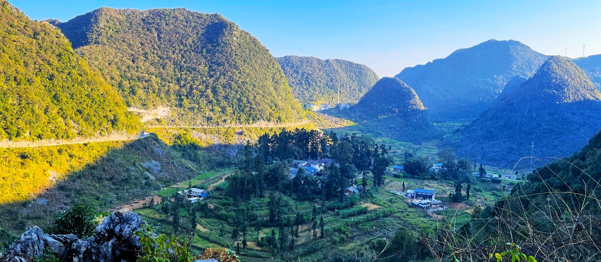
After you exit the Mã Pí Lèng Pass, QL4C straightens out as it heads south to Mèo Vạc, a scruffy, friendly town that sits in a sheltered basin, bathed in blue shadows cast by the ubiquitous, looming limestone karsts. Mèo Vạc has plenty of accommodation options, mostly around the central stadium. For private rooms, Hostel Thanh Thành is clean, cheap and extraordinarily friendly. Quang Minh is also a good choice for private rooms. Giang Sơn has dorm beds. For homestay vibes, check out Lo Lo Guesthouse and Đá Nhớ Homestay. For some of the most atmospheric lodgings in the entire region, head out of town to the Auberge de Meo Vac. A small boutique accommodation housed in an old Hmông family home with a beautiful stone courtyard and adobe walls, the Auberge has dorm beds on the floor or private rooms. Book ahead as they can only accommodate about a dozen guests.
You’ll find cheap eats in and around the central market. Ngọc Lan Quán may be the best restaurant in town. Here you can essentially order whatever you like and the communicative cooking team will cook it on the spot. If you know the names of some of your favourite Vietnamese dishes, now is the time to test your pronunciation. Alternatively, look up dishes on your phone and show them photos.
There’s not much to do in Mèo Vạc, but if you’re going for a stroll then include the gold Hồ Chí Minh statue and adjacent temple on your route. If you’re spending more than one night in Mèo Vạc and looking for things to do out of town, there are at least two good options. For a half-day trip take the side route (the red line on my map) and head down a spectacular road to the tourist boat pier on the Nho Quế River, from where you can sail through the Tu Sản Gorge. A full-day option is a mini-loop by motorbike taking you to Bảo Lạc in Cao Bằng Province and back through rugged farmland and on a bamboo ferry. If this appeals, jump to Section 6b for advice on how to go about doing it.


Section 6a/6b:
6a: Mèo Vạc→Mậu Duệ: 37km | 6b: Mèo Vạc→Bảo Lạc: 73km
[View Map]
*Note: If you’re continuing on the loop from Mèo Vạc, read Section 6a. If you’re forgoing the loop and heading to Cao Bằng Province from Mèo Vạc, ignore Section 6a and read Section 6b.
Section 6a (to continue the loop): Leave Mèo Vạc on Road DT182 (later marked as DT176) heading west towards Mậu Duệ. This road passes through a stark, rock-strewn limestone valley with some death-defying sections of mountain road. Unfortunately, the road was under construction at the time of research (November 2023) and looks like it will be covered in dust for a long time to come. There is at least one town of interest on the way – Lũng Phìn – with a few ancient houses, a bustling morning market and a raised temple built into the rock. There seems to be little of note in the crossroads village of Mậu Duệ, but there are coffee shops and restaurants along the main drag and at least one good guesthouse.
*
Section 6b (for onward travel to Cao Bằng): There are two separate routes heading southeast from Mèo Vạc down to Bảo Lạc: roads DT217 and QL4C. If you’re doing this as a day trip from Mèo Vạc and you have a decent bike, I’d recommend taking DT217 to Bảo Lạc and then QL4C back again to create a mini-loop. The former is the continuation of the Khâu Vai side route from Mèo Vạc (see the red line), but this route suffers from unpredictable road conditions. Just south of Khâu Vai village, DT217 crosses a bamboo raft ferry over the Nho Quế River and continues on the other side all the way down to Bảo Lạc. However, the road conditions around the rivers are very muddy, so unless you have a good off-road bike, it’s probably best to take the other route (QL4C) from Mèo Vạc to Bảo Lạc instead. At some points along DT217 you might be forced to dismount your bike and nurse it across waterways that have flooded the bike path.
By contrast, road QL4C is in good condition, leading south of Mèo Vạc, passing more gorgeous valleys and descending from a scenic pass to the Gâm River. QL4C crosses the river and ends at Lý Bôn, where it joins QL34. Turn left (due east) towards Bảo Lạc. It’s significantly warmer and lusher in this valley than up in the highlands around Mèo Vạc. Road QL34 is a beautiful route along a rich, fertile valley, but the road is cut out of steep slopes, so in rainy weather landslides are common.
Bảo Lạc, where several rivers converge, is a natural rest stop for travellers going between the Extreme North and the Northeast. There are some decent places to stay on the riverfront and plenty of food and drink. Sunny Bảo Lạc Homestay has rooms overlooking the river, but there are plenty more options. There are rice eateries and cafes on the dusty main street. Bảo Lạc has a decent market, which is at its busiest in the mornings. From Bảo Lạc, you can continue east on QL34 all the way to Cao Bằng City, or via the incredible Khau Cốc Chà pass to Pác Bó Cave, or south on DT212 to Ba Bể National Park. For more details on these roads and routes, take a look at my Northeast Loops and High Roads guides.


Section 7:
Mậu Duệ→Du Gìa | 38km
[View Map]
After arriving in Mậu Duệ if may feel as if you’ve left the dramatic scenery behind. Not so! Head south on DT176. This is an extraordinary road leading up a seemingly endless pass over a chain of high, jagged limestone peaks, then down the other side through pine forests and valleys. You’ll spot several roadside cafes that take advantage of the views along the way. Stop to scramble around the Tolkienian remains of a centenarian French fort, which was presumably built around the same time as the fortress in Đồng Văn (there is no information plaque). Then prepare for the breath-taking descent into an idyllic valley where the tiny hamlet of Du Già with its glut of accommodation options is located. Du Gia Panorama, Tom’s Du Gia Homestay and Tơ Dày Du Già are all off the main road and sit surrounded by rice terraces that glow green in the summer months. From here you are also close enough to walk to Du Già Waterfall (go at sunrise to avoid crowds; go at sunset for a party). There are lots of other activities nearby, including swimming in the river, fishing and hiking, all of which can be arranged through your accommodation.


Section 8:
Du Gìa→Hà Giang | 98km
[View Map]
Google might tell you to head south from Du Già back to Hà Giang City. This seems like a neat way to close the loop, but this stretch of DT176 is in bad condition, and it’s unlikely to get better any time soon. Instead, retrace your steps from Section 7 back as far as the junction at the French fort (the road is even more spectacular heading this direction) and then turn west on DT181. Save for a few rocky patches, this road is in good condition. Once you hit the Miện River, head south along an unnumbered road, which is scenic and good bar the occasional landslide. During its long descent back to Hà Giang, this road passes A Boong Waterfall and a river viewpoint before meeting QL4C. From here it’s just 10km back to Hà Giang City, thus completing the loop.


*Disclosure: Vietnam Coracle content is always free and independent. Joshua has written this guide because he wants to: he likes Hà Giang and he wants readers to know about it. For more details, see the Disclosure & Disclaimer statements and my About Page


Great guide Tom ad Joshua! Thanks a bunch.
Just drove the loop counterclockwise in 5 days, taking it slow (June 2025). You will get less caught up in tour groups if you go that way, but perhaps the clockwise route is more increasingly impressive landscapes. Up to everyone!
Couple of road updates:
We took the blue route (as opposed to the QL34 red route you have as an alternate). The first day, between Ha Giang and Du Gia, parts of the road are quite rocky and I suggest getting an offroad bike.
Also, they are currently building the road from Pa Vi village down to the river Nho Que (the Eastern-most detour in your route, other than the big loop). It’s drivable though.
Skywalk: great walk, very photogenic. It seems to be part of some tour groups’ itinerary now too though, but it’s a long walk, so you can still get great shots without too many people on them. Try going around lunchtime maybe.
We encountered police 3 times. While we had intl licences, they were issued in Japan, and that doesn’t count as Japan has not recognised the 1968 Geneva convention agreement. Thus we had to pay 3M dong fine. Any subsequent police we didn’t have to pay again though. Best to calculate that into your budget.
Keep it up guys!
Hi Mieke,
Thank you for the updates and trip report. I’m happy to hear you enjoyed your ride. Good point about riding the loop anti-clockwise to avoid the crowds. And, yes, the police checks and fines are common now, hence most travellers choosing to ride the loop pillion with a tour these days.
Best,
Tom
Where were the police checkpoints? Do you have any tips on avoiding the police stops? I am going to start my Ha Giang loop trip later this month. I am wondering if riding very early in the morning (5am) through key checkpoint areas may help me avoid getting stopped. Or, when I see a group tour, like the Jasmine tours, I just follow them through an area likely to have checkpoints to avoid getting caught.
Hi Varun,
There is no way to entirely avoid police check points on the Ha Giang Loop, especially now that it is so popular. Everyone gets stopped at least once on the loop and the locations can change regularly. Yes, riding very early in the morning might help. But remember that, if you are riding without a local license or a accepted international driving permit, then you are riding illegally, so the police have every right to stop you and, most probably, fine you. If this is a significant concern for you, then I would suggest riding in a different region of Vietnam that is not as popular as Ha Giang and therefore has a much lower police presence. You can also ask the reputable motorbike rental companies in Ha Giang about this.
Best,
Tom
Thanks for your reply Tom! I am already factoring in a “gift” to the police for my mistake of traveling without proper license. I’ll only do half the Ha Giang loop, then I’ll do the Cao Bang loop. I appreciate your guidance and will be ready to face the consequences of my actions.
Hi Tom,
I’d like to leave a trip report here for future travelers. I just completed the loop over the holiday weekend during April-May 2025. Weather in late April was still very good. Cool on some days, hot on others with very little rain to speak of. In a few weeks it will be extremely hot I suspect.
Many people ask about crowds. How is the loop these days? Well, crowds were indeed big on April 30th (Reunification Day) but this was to be expected, and they were manageable. The roads never really became traffic jams except at a few points on QL4C just leaving Ha Giang. From what I can tell, the busiest part of the loop is between Ha Giang and Yen Minh, with the 9 Turn Pass being particularly overloaded with people stopping to take pictures. The road itself, especially after Yen Minh, was totally enjoyable in terms of crowds. Will you be alone? No. Will you be mostly alone? Yes. Will viewpoints be crowded? Yes, expect to share them with groups of tourists and caravans. Morning driving was when the roads were most crowded, while after lunch and into the afternoon the roads were less crowded. I saw very few independent travelers. Most people were in motorbike caravans and tour groups. Truck, car and bus traffic was very light on all sections of the route.
As for police, there were many, many choke points. There was a police check point directly in Ha Giang city stopping all foreign independent travelers leaving east on QL4C. There was a second checkpoint between Ha Giang and Yen Minh (also QL4C, with friendlier police) and a third check point immediately after Yen Minh going east on QL4C. So that’s 3 check points within about 60 km. Between Dong Van and Meo Vac, there was one check point immediately before the Ma Pi Leng pass with friendly police. From Meo Vac to Mau Due on DT182, and from Mau Due to Du Gia on DT176 we saw no police. Also from Du Gia back to Ha Giang via DT176 and DT181 we saw no police. Regardless, independent travelers should be prepared to encounter police, it will 100% happen.
Road conditions on QL4C are in good shape all the way to Meo Vac. The flag pole road up to Lung Cu is in good condition, no issues at all. DT182 between Meo Vac and Mau Due is brand new and an excellent, excellent road. DT176 south from Mau Due to Du Gia is in poor condition and continues to deteriorate since my last trip. It’s totally rideable, but is bumpy and unpleasant after the great ride on DT182. Still though, the views on DT176 are incredible, not to be missed.
Regarding road conditions from Du Gia back to Ha Giang. I had considered going south on DT176 to QL34, but based on comments here decided instead to go north on DT176 then west on DT181. I’d be curious to try QL34 next time. DT181 leads to some exceptional views back down the valley, but the road isn’t great (especially through the valley and climbing out of the valley), and very unpleasant at many points. You are rewarded however when you link up with the “Unnamed road” and start heading southwest back to Ha Giang. This unnamed road (blue line south on your map near the Lung Tam valley view point) is in great condition, virtually empty, and has incredible views and no traffic. So, if you can handle 30-40 minutes of intermittently poor roads on DT181, then I’d recommend it. Next time though I will definitely go south on DT176 to QL34 and see how that ride is.
Also, I should mention, the Lo Lo Chai village at Lung Cu is worth staying in. Foreigners need a permit to stay but it can easily be arranged in 30 minutes with your hotel and a trip to the police station. It costs 250,000 VND per person. We saw no other foreigners whatsoever in the Lo Lo village at the base of the flagpole.
Finally, for anyone thinking of making the ride from Hanoi to Ha Giang directly on their own bike, it can easily be done in a day and I’d recommend it (at least for people like me). It takes 3 hours up to Tuyen Quang, then 3 more hours to Ha Giang. Once you get clear of Vinh Phuc province, the drive on QL2C and on QL37 is actually quite pleasant and easy. I feel like if I had stopped halfway I would have regretted it.
I hope this is useful for future travelers. Thank you Tom for the great guides.
Hi Brett,
Thanks for the trip report and road updates. I’m glad you enjoyed the ride!
Best,
Tom
Hi Tom,
i’m happy to report that DT176 from Meo Vac to Mau Due is in pristine conditions now! No roadside work anymore and besides a few potholes in the villages, the roads outside the villages are the best I’ve seen so far in Vietnam!
Also Kiki’s Guesthouse is a good place to rent motorcycles for all kinds of travelers wishing to do the Ha Giang Loop.
Thank you also for being our tour guide! We followed your guide for a four day trip, with a few detours and our own tempo. Really sad we don’t have the time for Section 6b, but this area is incredible! Especially the Sky Walk was super beautiful, thanks for the recommendations. I donated you a few bucks for dinner. Thank you!
Hi Yannick,
Firstly, thank you for your kind donation to my website, I really appreciate it.
It’s great to hear you enjoyed your road trip in Ha Giang and Phong Nha. Thanks for the update on road DT176 – good to know that’s in good condition now.
Best,
Tom
It seems to be very difficult almost impossible to get a bike without an international license. Since we are in Ha Giang already, we were thinking about maybe just going to a homestay in Du Gia for a couple of days and do some hiking from there. Is there a reliable and not to cheap way to get Tiere from Ha Giang? Maybe a private driver? There seems to be no Grab in this area.
And would you recommend Du Gia for a longer stay?
Hi Lucas,
For more details and recommendations about motorbike rental and tours (including riding pillion and Jeep tours), please see the Overview & Details section on this guide and scroll down to the sub-heading ‘Motorbike Rental & Tours’. You can try contacting and asking some of the places listed there.
For more about Du Gia, please read Section 7 of this guide and also this accommodation review.
Best,
Tom
Another great guide, thank you (I recommend buying the offline guide to anyone)!
If DT176 south of Du Gìa is in good condition now as other comments mentioned, would you recommend use it to finish the loop or would you still turn back and use DT181? Where are better views/less traffic, what do you think?
Hi Micha,
Thank you for the kind words.
Yes, it does sound like DT176 south from Du Gìa is now in good condition, which is great news. However, although both routes are scenic, I would still recommend completing the loop by staying on the blue line: heading back from Du Gìa north to the intersection at the Old French Fort, then turning due west on DT181 and then switching back due south on the unnamed road via the A Boong Waterfall and back to Hà Giang City.
Best,
Tom
Hi Tom, your website is second to none.
This will be our first trip to Vietnam, and I was planning a 4d/3n Ha Giang loop tour by car with my wife and 7 yr old son. We are regular roadtrippers so I hope it will be good for us. But the major attraction of it was to be in a remote area away from crowds, and now I’m concerned from my reading that it will be very crowded. We don’t have the proper license to drive ourselves and explore off the main route. Do you think our time would be better spent taking day trips from Ha Giang or another area, to find less crowded places with less drive time (since we don’t get to enjoy the motorcycle experience)? Let me know if you have any recommendations like that. Otherwise, if the scenery and cultural experience is worth the crowds in Ha Giang in your opinion, then I’m sure we will have a great time. Thanks for your thoughts
Hi Dave,
I understand your concern. There is no denying that the typical Ha Giang Loop is very popular now and can be quite busy with travellers. While this does take a bit of the thrill away, the landscapes are still sensational, so the majority of people still love the experience.
What’s more, as foreign travellers in Vietnam, you won’t be able to self-drive a car, so you will need to hire a car and driver: Ha Giang has several options for this, including open-top Jeeps run by Style Motorbikes. But if you choose to drive somewhere else, you can hire a car and driver by enquiring through your accommodation. The cost is usually around $100/day.
If you really do want to experience Vietnam without the crowds, I would suggest that you consider hiring a car and driver in Pu Luong or Mai Chau and then exploring the Limestone Loops. Alternatively, hire a car and driver in Sapa and explore the Sin Ho Loop and Y Ty Loop.
Best,
Tom
Hi thanks your guide is amazing. I have a question because actually many say difficult but not impossible and others highly dangerous..the question is: In your opinion can I drive Ha Gian Loop with a fully automatic scooter? I’ve already been driving it for over a month from the.south I’m on my way up.Thanks!!!
Hi Consuelo,
As long as the automatic motorbike you’re using is in good condition and you are not intending to go off road, then it is absolutely fine to ride the Ha Giang Loop on a fully automatic bike. In fact, I have personally ridden the Ha Giang Loop about a dozen times on my own automatic motorbike! 🙂 But, of course, wherever you ride in Vietnam and whatever bike you’re using, you should always be extremely careful.
I hope you enjoy the ride.
Best,
Tom
Hi Tom thank you for your reply. Ok perfect I will stop at a mechanic’s so I can have the brakes and wheels checked.
Thank you so much!
Hi Tom, Joshua,
Great content, thanks!
Do you think it would help to avoid crowds if I did the loop counter clockwise? It seems that the direction the tours are taking is mainly clockwise. Would anticlockwise direction be worse in any way regarding the views and difficulty of ride?
Hi Sasa,
Yes, that might help. However, the roads will be just as busy, only that most of the vehicles will be going in the opposite direction to you. In terms of scenery, there’s no reason why going in one direction is any more or less beautiful than the other.
I hope you enjoy the ride!
Best,
Tom
Hi guys, anyone been down the DT176 or is this still a bit of a no go?
Thanks
J
Hi James,
According to recent comments (such as those from Kurt), the condition of DT176 going south from Du Gia is now fine.
Best,
Tom
Thank you Tom
Hi Tom,
Great website, thanks. We’re currently at a farmstay in Lam Thuong and were planning to head up to Ha Giang and hire some motorbikes, but we’re a bit put off by the air quality where we are at the moment. Do you have any sense of whether it will be any better on the loop and how much this might affect visibility and scenery?
Cheers
Geoff
Hi Geoff,
Weather conditions are constantly changing and famously unpredictable in the northern mountains. Try using Windy.com. Zoom in on the Ha Giang region of Vietnam, then you can choose from a number of options, including cloud cover, and run the satellite over several days to see what the weather patterns are predicted to be. I just did it briefly and it looks like a mixture of clear skies and cloud cover for the next 2-3 days.
Best,
Tom
Hey Tom, any recommendations for a route from Hanoi to Ha Giang City? For some reason, I cannot find one in the guide.
Hi Marc,
This guide is about the Ha Giang Loop, so it does not include routes from Hanoi to Ha Giang.
To get to Ha Giang from Hanoi, I would recommend taking this bus, which can also transport your bike, or you can easily rent a bike in Ha Giang instead. Alternatively, if you want to ride from Hanoi to Ha Giang, you could consider adding the Tuyen Quang Magic 8 Loop on your way and stopping at the homestays on Thac Ba Lake too. (Bear in mind that the most direct route to Ha Giang is on QL2 and that motorbikes are generally not allowed on the CT roads, which are expressways.)
Best,
Tom
hello Tom,
Thanks for all the infos you shared with us !!!
I’m just realizing, Is Ma Pi Leng really a pass ? I mean as I can understand it in French (going up to a point – le col – and then going down on the other side).
I am trying to make a good map of the Ha Giang Loop for a book, after travelling there a few times last year, and I can’t precisely point to the Ma Pi Leng pass on the map…
What do you think ?
Hi Sophie,
Yes, the Mã Pí Lèng Pass is called a pass (đèo) in Vietnamese. You can see my map for the location and read about the Mã Pí Leng Pass in this section of the guide. As I understand it, a pass doesn’t necessarily go up and down a mountain; it can also navigate a mountainside or a cliff or a ridge.
Best,
Tom
Thank you Tom !!
Hii, anyone knows where to rent bicycles suitable for the loop in Ha Giang?
Thanks
Hi Akos,
Some of the motorbike rental places listed in this guide may also be able to arrange bicycles. Please go to the Overview & Details section above and scroll down to About The Loop and then look for the subheading ‘Motorbike Rental & Tours’.
Best,
Tom
I just purchased the offline guide, thanks dude.
I got myself a Honda Wave for while I’m in Vietnam and will sell it before I go. This guide has me so excited, I’m either heading off tomorrow or the day after to do the loop, currently in Hanoi. I’m gonna take my sweet time and enjoy as I’m an avid photographer focusing mainly on portraits. Any extra tips for the winter season? I’ve got layers and gloves, rain coat and extra poncho and rain covers for my bags. I’d love to be able to visit small villages and capture some of the local people going about their day. Again, super friggin excited, it’s currently 4am and some dude is snoring his head off in the dorm room.
One other question, sorry. I’m not exactly a early riser so would you think I’d have enough time to explore if I set off most days around 11/12? Or is it better to just suck it up and get up and on it early? I wanna take around 7-10 days doing it.
Hi Mikey,
Ha Giang should be great for portrait photography. But, yes, it is best to get up early – this is often when people in Vietnam are most active, especially in the countryside. Try to see some of the local markets on the loop – if you go to the museum in Ha Giang city, you will find a calendar with all the market times on (see the Ha Giang City guide).
It is pretty cold up in Ha Giang now, so definitely make sure you’re prepared – people don’t realize how cold it can feel on a motorbike on the high passes.
It is a great idea to take your time and to have plenty of days to explore the main loop and the smaller roads beyond it. Bear in mind that the main loop is really popular now, so there are lots of other travellers. However, just take a turn off the main loop, and you can still find isolated roads and villages.
I hope you enjoy it.
Best,
Tom
I can no longer ride a motorcycle. Would like to do a 5day open air jeep tour. Any suggestions for a reputable tour operator
Hi Kent,
Try Style Motorbikes – they have good Jeep tours in Ha Giang.
Best,
Tom
Thanks for the excellent guide to the loop. Especially loved your suggestions about Núi Cấm in Hà Giang, Tham Luồng Cave, the Mã Pí Lèng Skywalk, the boat ride in Tu Sản Gorge, and pretty much the whole section from Mèo Vạc to Du Gìa.
DT176 south of Du Gia is in really good shape now. There are a couple short sections (~100m) of rough gravel but most of this road is either brand new pavement or smooth gravel. A lot of construction vehicles and workers were present, so hopefully they will finish those rougher sections soon. We traveled the road via car on November 22 and our driver was expecting it to be terribly rough and slow going based on his previous experience with the road. However, we were both pleasantly surprised about the good conditions. The road down to Tu Sản Gorge was much more difficult and rough than DT176.
Hi Kurt,
Thank you for this valuable and useful update. It’s great to hear that the road south of Du Gia is now in good condition – it’s been bad for so many years.
I’m glad you enjoyed your trip around Ha Giang.
Best,
Tom
I did the loop twice in the last year. It has become quite crowded in sections and the packs of easy riders can be a bit much. Best bet is to start your day very early, the groups don’t seem to get out before 09:00.
I was stopped daily by police but have a VN license so no issues, never asked for a blue card or insurance card. The fines for those with no license, or improper IDP, was 1.5-2m VND. You received a waiver that could be used for subsequent stops but not sure if it was for the day or your entire trip. No government tickets were issued nor were motorcycles seized as often happens in other jurisdictions. Of course this is a fluid situation so best to be legal, especially for insurance and liability reasons.
Regarding the Đồng Văn Geopark permit, on both trips I had to purchase one when overnighting in Lo Lo Chai. The homestay took care of it but it was compulsory. No issues anywhere else in the Geopark.
I also always try to catch the Sunday market in Dong Van or Meo Vac (I prefer Meo Vac as they have a cattle/livestock market area).
Thanks for a great read, I learned of some new side routes that I’ll be checking out.
Hi Mark,
Thanks for your trip report. As you say, the situation is ‘fluid’ – there’s always a lot of changes up on the loop, but the scenery is as magic as ever. I hope you, and everyone else, continue to enjoy exploring the region.
Best,
Tom
Hey Tom. I think I learned more from your website in the last hour than from all other sources in the last weeks. Kudos!
I have two questions for you:
1. Do you think that the average police man around the Ha Giang loop really cares if my IDP is issued in Canada? (I’ll be carrying my valid Canadian motorcycle driver’s license as well). I mean, what are the chances that a typical police is aware (or even care) that some countries like Canada and USA didn’t ratify the 1968 Vienna Convention on Road Traffic? I know that is technically illegal to ride a motorcycle in VN with a Canadian driver’s license even with a valid IDP, but I want to have an idea of how much hassle I should expect. I’d hate being stopped all the time and having to pay multiple times the average “fine”. Common sense tells me the chances are low, and that if it happens it shouldn’t be more than once or twice on a 7 days trip, but I really want to know your thoughts on this.
2. Do you know any rental company on Ha Giang or Hanoi that also offers third party insurance as well as coverage for the bike itself? I never even though about this in the multiple times I rented bikes in Thailand but after watching videos it looks like the Vietnamese are more aggressive drivers so I wouldn’t mind paying extra for insurance. My health/life insurance is provided by my Company and it’s pretty comprehensive. so no worries there
Thanks in advance!
Cheers,
Hi Julian,
It’s difficult to say for certain. You’re probably right and if you were riding anywhere else in Vietnam apart from Ha Giang, it would be unlikely to be an issue. But Ha Giang is so popular now that police checks are very regular.
For third party insurance it’s best if you contact the rental companies to ask.
Best,
Tom
SECTION 6a: They have been working hard for the last few months and the DT182 between Meo Vac and Mau Due is halfway finished. On another part, onr lane is finished. But yes, there is still a part that is being worked on and it is long enough to cover you and your bike with a thick layer of dust. And if you arrive in Mau Due and feel too dirty or too tired to continue or you don’t feel like staying in Du Gia with hundreds of other bikers, Nha nghi Tuong Cham is a good place to stay for a night. 300,000 VND for an almost new, very clean room is a good deal.
The Ha Giang Loop is really great, especially if you like being third row at a viewpoint among 100 bikers or waiting 10 minutes at a gas station because two groups of bikers had the same idea. Seriously: The scenery is great, the roads mostly good, but being on the same route with hundreds (thousands?) of bikers at almost the same time is, let’s say, disturbing.
Hi Frank,
Thank you for the useful update about the conditions on road DT182.
As for the crowds in Ha Giang: yes, I think that is now something for travellers to bear in mind if considering the Ha Giang Loop. It’s amazing how popular the region has become, and so quickly. But, of course, crowds of travellers can detract from the adventure. Fortunately, there are many other spectacular routes to choose from in Vietnam that are not so crowded.
Best,
Tom
Which route would you recommend instead of Hi Giang?
Hi Eva,
There are many other great motorbike loops in the north as well as the Ha Giang Loop. For example, the Limestone Loops, Sin Ho Loop, Muong Long Loop. You can also take a look at my 13 Northern Loops.
Best,
Tom
Before coming to Ha Giang my plan was to book
a guided tour. However, i’m so glad I decided to go independently using this detailed guide – it’s truly been a game changer (and at times a lifesaver). Josh is such a fabulous writer!
Hi Mark,
Thank you! It’s great to hear you enjoyed the route and reading this guide.
Best,
Tom
Hi Tom. Fantastic website. I’m planning a bicycle tour through North Vietnam for this fall and I’m stitching together your routes from Lao Cai to Cao Bang. I’d love to incorporate as much as the Ha Giang loop as possible, but given I’ll be going one way, I’ll have to cut off some sections. Are there any parts you consider can’t miss? My priorities as a cyclists are amazing views and minimal traffic; I’m good at suffering and am no stranger to long, hard climbs. Thanks in advance!
Hi Alex,
For the best roads and scenery, stick to the northern part of the Ha Giang Loop as much as possible. Du Gia is an exception to this, but in general if you are only travelling one way on the loop, the northern route is best. However, it’s also true that the northern part of the loop has much more tourist traffic (mostly motorbikes) than the southern part.
Best,
Tom