Sapa to Ha Giang by motorbike on borders & back-roads, Vietnam

Borders & Back-Roads: Sapa to Ha Giang by Motorbike

Last updated October 2018 | Words and photos by Vietnam Coracle

This post was last updated 5 years ago. Please check the comments section for possible updates, or read more on my Updates & Accuracy page.

INTRODUCTION | GUIDE | MAP | RELATED POSTS

Sapa and Ha Giang are gateways to the outstanding mountain scenery of Vietnam’s northwest and extreme north respectively. But the journey between these two mountain towns is just as thrilling as the landscape which lies beyond them. Connecting two of the most mountainous provinces in the country (Lào Cai and Hà Giang), this motorbike route straddles the Chinese border, carving a meandering course over mountain ranges and along river valleys. Largely on small roads that have only recently been blasted out of the mountainsides, this road trip is a slow crawl through some of the remotest parts of Vietnam. Dramatic scenery, fascinating border towns, ethnic minority markets, and lush farmland abound. This is a route to be taken slowly – there’s hardly a kilometre without a hairpin bend – and with plenty of time to allow for unforeseen circumstances, such as bad weather and landslides, which regularly block the way. This road trip is the perfect link for riders wanting to connect the northwest with the extreme north, or as an alternative to, or extension of, the increasingly popular Ha Giang Loop.

Sapa to Ha Giang by motorbike on borders & back-roads, Vietnam

Riding from Sapa to Ha Giang along back-roads close to the Chinese border is an epic & scenic road trip

[Back Top]


GUIDE: SAPA TO HA GIANG BORDER ROUTE


ROAD TRIP DETAILS:

  • Total Distance: 355km/480km/235km (one-way)
  • Duration: 2-5 days
  • Route: hugging the Chinese border on back-roads from Sapa to Ha Giang [MAP]
  • Road Conditions: paved back-roads, some rough & gravel sections, light traffic
  • Scenery: mountains, gorges, borderlands, terraced rice fields, minority villages


ROAD TRIP CONTENTS:

  • SECTION 1: SapaMuong Khuong (via Road QL4D): 85km
  • SECTION 2Muong KhuongSi Ma CaiBac Ha (Chinese border route): 90km
  • SECTION 3Bac HaXin Man (direct/via Pho Rang): 40km/165km
  • SECTION 4Xin ManHoang Su PhiHa Giang (plus side routes)140km

ABOUT THIS ROUTE:

Selected Resources What’s this?

On my map below, I’ve plotted three routes between Sapa and Ha Giang. The Border Route (the blue line: 355km) follows the remote Chinese border; the Alternative Route (the red line: 480km) offers a scenic detour before linking back up with the Border Route; and the Direct Route (the green line: 235km) stays mostly on main roads, missing out much of the remote and spectacular scenery on the other two routes. I’ve also included several side routes (the pinkish lines), but there are many other scenic back-roads to explore if you have the time, and preferably a good, off-road motorbike. I’ve written this guide in 4 sections, going from west to east from Sapa to Ha Giang following the Border Route (the blue line). Note that each section doesn’t necessarily correspond to one day on the road. I’d recommend spending between 2-5 days on this route, depending on weather and road conditions. Any of the three routes marked on my map can be ridden in either direction, or can be turned into a loop by going out on one and returning on another. Note that all three routes suffer from landslides after heavy rains, and ongoing roadworks which can slow you down considerably. I’ve marked specific rough road sections on my map as best I can. If possible, try to time your trip to coincide with a weekend, as all the towns on this route have lively markets, which draw colourfully-dressed ethnic minorities from across the region. Weather is best in spring and autumn, the latter coinciding with the bright colours of the rice harvest. September is my favourite month.


ROUTE MAP:

Sapa→Muong Khuong→Bac Ha→Xin Man→Hoang Su Phi→Ha Giang

Border Route: 355km | Alternative Route: 480km | Direct Route: 235km


View in a LARGER MAP

[Back Top]


SECTION 1

Route: SapaMuong Khuong (via Road QL4D) | Distance: 85km [MAP]

The first section of this road trip is all on Road QL4D, which winds northeast of Sapa, down into the Red River valley to Lao Cai, on the Chinese border, and then up a long mountain pass to the little visited outpost of Muong Khoung.

Leave the mountain resort town of Sapa by way of the steep and meandering Road QL4D. Sapa is currently a bit of a tourist trap and a building site, so it’s a relief to leave the town and get onto the open road with some sensational views of the surrounding scenery. In less than an hour, the scenic, winding road takes you down to the Red River valley, which is noticeably warmer (and a lot less cloudy) than Sapa.

Selected Resources What’s this?
View of Sapa & surrounding mountains, northern Vietnam

Leave the mountain resort town of Sapa & wind down to the Red River valley on Road QL4D

The dusty but busy town of Lao Cai sits right on the Chinese border. It’s a major gateway for trade between the two countries, especially now that the new Expressway CT05 has opened, linking Lao Cai with Hanoi. If you have time, head along the river to the main border gate with China. There’s a strangely compelling atmosphere here, as informal trade passes from country to country, oftentimes on the backs of bicycles pushed across the border by older women. Coc Leu Market is a fascinating place to browse some of the products – both Vietnamese and Chinese – that pass through this border region. And, as with all Vietnamese towns, exploring the backstreets of Lao Cai can lead to some rewarding street food experiences, and discoveries of leafy, local spots. Lao Cai is also home to the train station where you can send your motorbike to/from Hanoi. There are lots of mini-hotels around the station: Kim Cuong Hotel [BOOK HERE] is where I stayed and is good value for money.

Street food in Lao Cai city, northern Vietnam

Lao Cai is an interesting city & a major border gate to China. It’s back streets are good for street food

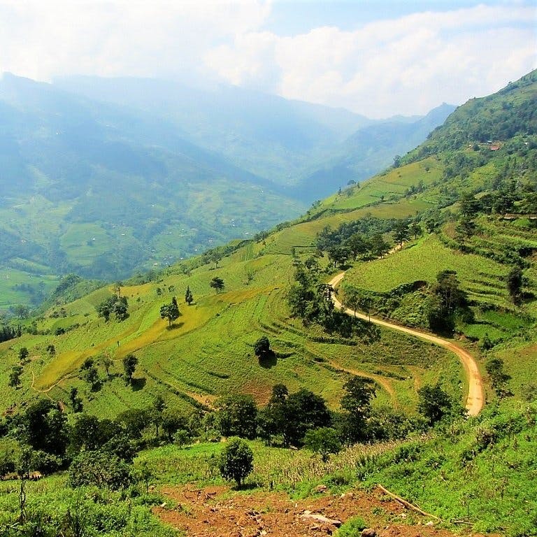
Shoot across the muddy waters of the Red River and head northeast out of Lao Cai. After around 10km, turn left (due north) and continue on Road QL4D towards Muong Khuong. The early stages of this road pass through acres of pineapple plantations, which, although they sound exotic, don’t actually look that appealing when planted in hundreds or thousands of rows across the hillsides. The road surface has recently been upgraded on this route, but landslides can badly graze the tarmac in the rainy season, and trucks ply this route to and from plantations and remote border crossings. However, after 20km the road starts to climb steeply, and all the traffic (and pineapples) fade away. The scenery opens up to reveal the pleats and folds of lush valleys, their little rivers chiseling out a course between sloping mountains. Then Road QL4D aims skyward, not stopping until it’s over 1,000m high. Waterfalls and streams gurgle by the roadside, inviting you to wash the dust from your face, before gliding along the last 10km – a spectacular ride next to a terrifying drop – to Muong Khuong town. Throughout the ride, China is visible just over the mountains to the west.

Note: If you want to take the Direct Route (the green line) to Ha Giang, stay on Road QL170 (also marked as AH14) out of Lao Cai, due southeast towards Pho Rang [View Map].

Road QL4D to Muong Khuong, northern Vietnam

Road QL4D to Muong Khuong is really steep will excellent views over the valleys towards China

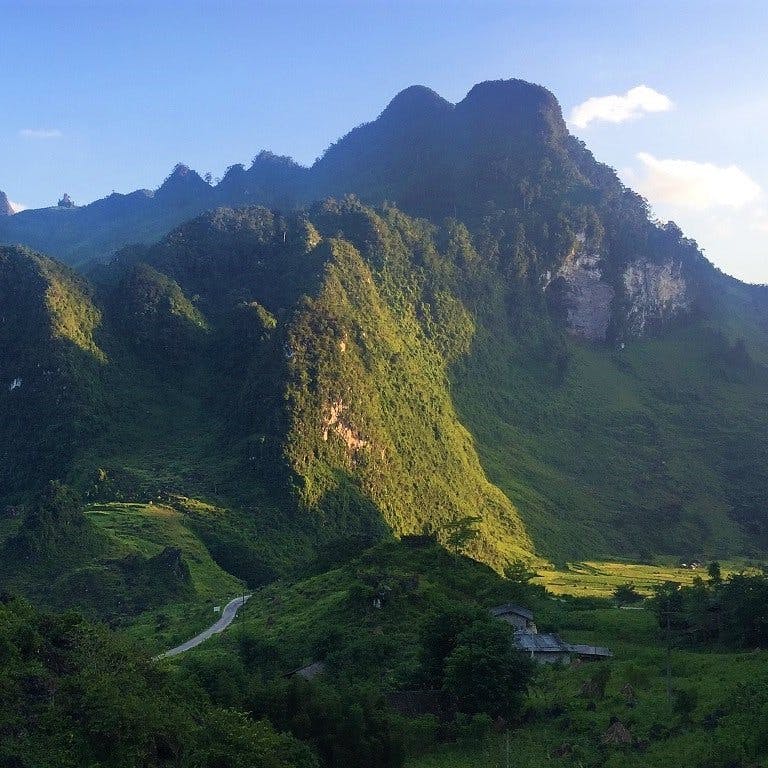
Just a few kilometres from the Chinese border, Muong Khuong is a strange and isolated place. Hemmed in on all sides by a ring of limestone pinnacles, it’s a mythical setting for a rather ugly town. Ugly, but interesting. Muong Khuong was a remote outpost of French Indochina, and when I first visited there were still a few crumbling buildings left from that era. (However, on my most recent visit, in 2018, I couldn’t find any trace of the old structures, which means they’ve been demolished.) Much of the town was destroyed during the 1979 border war between Vietnam and China. Muong Khuong has a good market on weekends that attracts many of the ethnic minority groups living in the vicinity. A couple of OK nhà nghỉ (local guest houses) can be found on the high street, but the newly opened Muong Khuong Hotel (Tel: 0 166 233 6999; 200,000-350,000vnđ) is a much better option. There’s not much food available, but you can still find a few empty rice eateries (quán cơm) and cafes along the main drag. Although I wouldn’t linger long in Muong Khuong, I do find it a fascinating place to be for a night.

Muong Khuong town, Lao Cai Province, northern Vietnam

Muong Khuong is a fairly ugly town in a dramatic & mysterious location, surrounded by limestone pillars

[Back to Contents]


SECTION 2

Route: Muong KhuongSi Ma CaiBac Ha (Chinese border route) | Distance: 90km [MAP]

The journey between Muong Khuong and Bac Ha, echoing the Chinese border for much of the way, is only 90km, but it can take all day because the roads are extremely mountainous and the views are superb. Connecting dozens of small minority hamlets and remote army outposts, Road DT153 climbs up and down several mountains and above deep river gorges, before heading south through the strange settlement of Si Ma Cai and on to the famous market town of Bac Ha.

Waterfall by Road DT153, Lao Cai Province, Vietnam

The border route from Muong Khuong to Bac Ha via Si Ma Cai is spectacular & remote

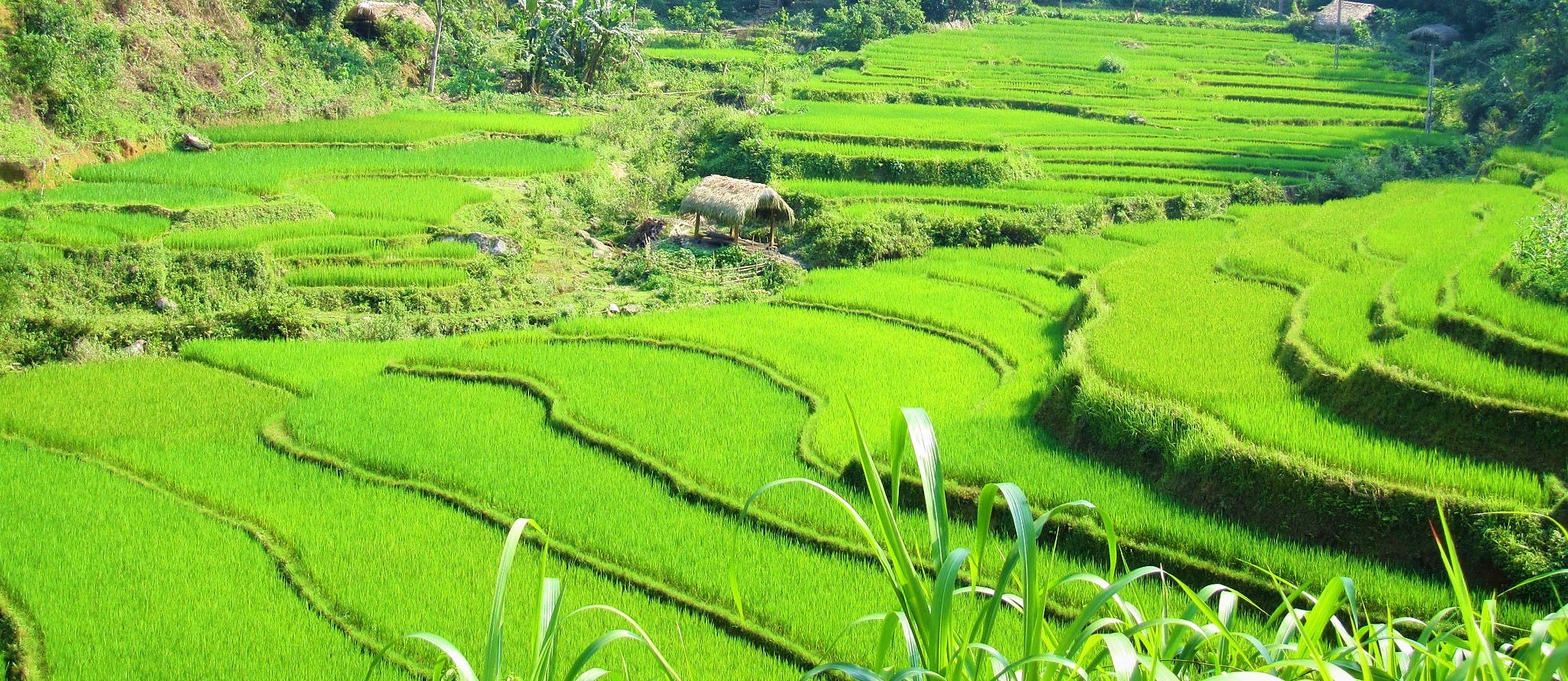
It’s a good idea to start reasonably early in the morning from Muong Khuong. Take Road DT153 northeast out of town. Almost immediately the road carves a path along the edge of a high precipice; above waterfalls, terraced rice fields, and tiny hamlets far down in the valley below. Limestone peaks surround the scene, acting like the crenulated ramparts of a medieval castle, enclosing the valley and keeping it safe. Most of this section of road was only paved in the last few years, and already there are regular landslides that cover the road surface in boulders and earth. Expect some rough sections here and there, and perhaps landslides if there’s been heavy rain recently. But, if you’re lucky enough to have good weather, it’s one of the most dramatic and remote rides in the country.

Terraced rice fields, Lao Cai Province, Vietnam

The scenery along Road DT153 as it follows the Chinese border north of Muong Khuong is marvellous

At Pha Long, the northern-most point of this route, there’s a lively, rustic market on weekends, which benefits from a nearby Chinese border crossing that appears to be very fluid. You’ll find Chinese toys, beer, and rice liquor (consumed in great quantities from the early morning onwards) on sale here. From Pha Long the road turns south, following the course of the My Phu River, along a spectacular valley dominated by limestone mountains. A deep gorge forms the Vietnam-China border, which the road navigates with perilous switchbacks above sheer drops of hundreds of feet. It’s very apparent that, on the Vietnamese side, all land is cultivated – from the river banks to the mountaintops – whereas, on the Chinese side, there’s hardly any sign of human activity: no roads, fields or buildings, just a bare mountain wall. Apart from the great views, I love the strange feeling that comes from being so close to the border of a country as big (and powerful) as China.

Motorbiking the Vietnam-China border, Lao Cai Province, Vietnam

A deep river gorge forms the border between Vietnam and China: it’s a fascinating sight

Leaving the Chinese border behind, Road DT153 corkscrews over several spectacular passes before crossing the Chay River (a great waterway that’s a continual presence on this road trip) before climbing again to reach the alpine settlement of Si Ma Cai. Set on a lovely crest of land surrounded by steep peaks reaching over 2,000m, Si Ma Cai is a strange town in the middle of nowhere. The original village is no more than a crossroads, but there’s now a vast new town to the south with wide boulevards, empty squares, and over-sized government buildings. Massive construction – to prevent landslides and flooding – is ongoing. If you feel like stopping for the night, there’s a decent guest house right at the town’s crossroads: Hong Nhung Hotel (tel: 0203 796 846; 200,000-400,000vnđ). Several good, local rice eateries offer hearty mountain dishes for lunch, and there’s surprisingly good coffee and fast food snacks at Coffee Moc.

Rice terraces & hamlet, Lao Cai Province, Vietnam

Si Ma Cai is a strange little town in the middle of nowhere surrounded by lush alpine scenery

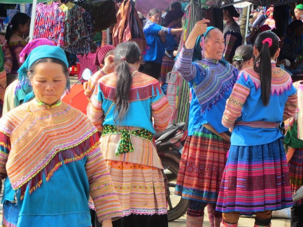
The ascent out of Si Ma Cai is so steep that some motorbikes may struggle if there’s a passenger on the back. It can get very cold at the top (even in summer), but the views are outstanding once again as Road DT153 continues south towards Bac Ha. It’s interesting to note that, although this is one of the more remote parts of Vietnam, the population density is surprisingly high. There’s always some activity going on in this big landscape: people working in the fields, walking along paths to isolated homes on the mountainsides, herding cattle, chopping wood in the forests. Most of the population here are from Vietnam’s ethnic minorities. With over 50 different ethnic groups, these minorities only make up about 15% of the country’s population, but they are concentrated in highland areas, especially in the north. Most minority people make their living from agriculture. Such is the density in Lào Cai Province that there’s hardly any ‘unused’ land: the entire landscape is cultivated. Minority children are always excited to see foreigners. It’s a good idea to carry some snack food with you to offer these kids (as an alternative to money) and put wide smiles on their faces. Between Si Ma Cai and Bac Ha, the lively minority market of Can Cau is bursting at the seams on weekends.

Children near Bac Ha, Lao Cai Province, Vietnam

The majority of the population in this area are from Vietnam’s many & diverse ethnic minorities

Not far beyond Can Cau market, Road DT153 meets Lung Phin junction. This is the turning (due east) for the direct route to Xin Man, but it’s worth continuing another 15 minutes or so further south on DT153 for a night in Bac Ha first, especially if you’re in time for the weekend. Descending sharply through pine trees, the town of Bac Ha comes into view, nestled in a valley. Bac Ha’s Sunday Market has become a favourite attraction for foreign and domestic tourists alike. Every weekend, thousands of minority people – the women all dressed in brightly coloured traditional clothing – make the long journey on foot from their homes in mountain villages to the market. The market really is quite a spectacle. There’s a hot food section where men eat delicious bowls of noodles, smoke bamboo pipes, and consume large amounts of potent local grain liquor. Meanwhile, the women wander through the market’s wide spread of stalls, buying clothes, food, and supplies for the week ahead. It’s a lively, vibrant market with lots to see. However, try to get here as early as possible because, from about 9.30am, hundreds of tourists arrive on buses, armed with big SLR cameras with giant detachable zooms, that many proceed to stick in minority women’s faces: suddenly it feels more like a zoo than a market. (For more about Bac Ha Sunday Market read my full guide HERE.)

There are plenty of places to stay in Bac Ha. I like the Nhat Quang Hotel (tel: 0214 3800 689; 200,000-500,000vnđ a night) on the main square, just a stroll away from the market, but there are many more to choose from, some of which you can browse here. The town has lots of local rice eateries.

Bac Ha Sunday Market, Lao Cai Province, Vietnam

Bac Ha is famous for its colourful Sunday Market: a sight to behold, despite the arrival of mass tourism

[Back to Contents]


SECTION 3

Route: Bac HaXin Man (direct or via Pho Rang) | Distance: 40km or 165km [MAP]

There are two very different routes between Bac Ha and Xin Man (also known as Coc Pai). The direct route (the blue line) is only 40km, taking a scenic road due northeast of Bac Ha near the Chinese border, all of which has recently been repaved (after years of road works). The indirect route (the red line) is much longer (165km), but also very scenic. However, the indirect route suffers from rough road sections and landslides. In my opinion, if the weather is bad there’s no reason to take the indirect route. But in dry conditions most bikes and riders should be able to make it, providing they take it slowly and carefully. I’ve tried to mark the rough road sections on my map as best I can. You’ll have to make the decision yourself when you get there, but either way, it’s another day of beautiful landscapes.

The road to Xin Man, northern Vietnam

There are two routes between Bac Ha & Xin Man: one short, one long: both are exceptionally beautiful


Direct Route: Bac Ha to Xin Man via Lung Phin & the Chinese border

Head north of Bac Ha on Road DT153, retracing the last 10km of the previous day’s ride, until you meet the junction at Lung Phin. Turn right (due northeast) onto the direct route to Xin Man. The road is in excellent condition for most of its 30km length. The first half meanders around the mountainsides with lovely views down over terraced rice fields and the high peaks in China, just a few kilometres to the north.

Admiring the view on the direct route to Xin Man, Vietnam

The direct route to Xin Man follows close to the Chinese border with grand views across deep gorges

The second half to Xin Man, after crossing the provincial border to Ha Giang, is even more spectacular, passing above a steep gorge on the Chinese border, before descending sharply via a series of severe switchbacks to Xin Man. For many years, this road was only accessible to experienced riders with suitable off-road bikes; now anyone can enjoy it.

The road to Xin Man, northern Vietnam

The last 10km to Xin Man are extremely mountainous with lots of switchbacks & sections of rough road

The town of Xin Man sprawls around a steep outcrop, high above the valley. It’s a dramatic setting, and the town’s streets reflect the contours of the land it sits on: curving and swirling above the Chay River. Xin Man is very remote. Behind the town are large limestone cliffs and mountains, beyond which is China. There are only three access roads to Xin Man, all of which are subject to regular landslides: it’s hours from any significant settlement. In nice weather, the scenery is sublime; in bad weather, it’s a grim, end-of-the-world kind of place. There’s a relative glut of accommodation, in the form of mini-hotels and local guest houses (nhà nghỉ), on Xin Man’s main street. I like the large, clean rooms with balconies at Ngoc Son Motel (tel: 0219 3836 470; 200,000-400,000vnđ). There are some standard cơm phở (rice and noodle) eateries serving hearty meals just around the corner. On weekends there’s a large market, and even on weekdays this is a good place for a local breakfast of noodle soup.

Rice terraces near Xin Man, northern Vietnam

Xin Man is a very remote town built on a steep slope surrounded by mountains & fields

[Back]


Indirect Route: Bac Ha to Xin Man via Pho Ranh & Quang Binh

The indirect route between Bac Ha and Xin Man (the red line) is 165km, so start early if you want to complete it in one day. Leave Bac Ha on Road DT153 heading south. A long and scenic mountain pass leads all the way down to the Red River valley, where it joins Highway QL70 (also marked as AH14). Turn left (due southeast) onto the highway and continue along the lush valley for 40km to the crossroads town of Pho Rang. Now that the new Expressway CT05 (on the opposite side of the Red River) takes most of the heavy traffic, Highway QL70 is a fairly pleasant ride through fruit plantations and hamlets of stilt houses. Pho Rang’s rice eateries make a convenient lunch, and there are also guest houses here if you need to stop for the night.

Rice terraces on the road to Xin Man, Ha Giang, Vietnam

The main road from Bac Ha to Pho Rang runs along the Red River valley with lush landscapes

From Pho Rang, head north on Road QL279. After crossing a bridge over the Chay River, this excellent road leads through a peaceful, verdant landscape, characterized by rice fields, different varieties of palm tree, and attractive rural hamlets clustered around clear rivers. After 25km the road bends east, entering Vietnam’s northern-most province, Ha Giang. Unfortunately, the border between provinces is made apparent by the immediate deterioration of the road surface. Smack on the provincial border asphalt turns to mud and rocks: welcome to Ha Giang. It only lasts for 10km until the next turn off at Quang Binh village (also known as Yen Binh), but in wet conditions this section of rough road can be quite challenging. At Quang Binh there are some places to eat, and even one or two local guest houses if you get stuck here.

Dirt road conditions, Phong Rang to Xin Man, Vietnam

At the provincial border between Lao Cai & Ha Giang on Road QL279 road conditions deteriorate

From Quang Binh, turn due north on Road DT178. This is a long, meandering, and utterly beautiful road, leading over a large reservoir, through a gorgeous valley, up a mountain, and down the other side to Xin Man town, near the Chinese border. In good weather, this back-road is my favourite part of this road trip: rich and verdant, with cascades of terraced rice fields, surrounded by high, forested mountains, spouting waterfalls which run into streams leading through pretty villages of wood-and-thatch homes, However, road conditions have worsened in the last few years: several sections are under repairs, and others are prone to landslides. Expect some rough sections and delays, especially if there’s been a lot of rain.

Road DT178 to Xin Man, Ha Giang Province, Vietnam

Road DT178 passes glorious landscapes, meandering through valleys, over mountains & by waterfalls

On Road DT178, there are several homestays near Na Tri village which are well worth stopping for a night. But, if the sun is shining, I’d continue on up the spectacular mountain pass leading straight over the Chay River Massif. At times this pass is so steep that all vehicles struggle against the gradient. Near the summit the road surface can be pretty bad, but the scenery makes up for it. The air is thin and cool at the top, and the views north and south are very grand indeed.

Terraced rice fields on the road to Xin Man, Ha Giang, Vietnam

Terraced rice fields cascade down the hillsides near Na Tri, where there are several homestays

Descending the other side through thick forest there’s a tree by the roadside with a small altar next to it. A plaque announces that this tree is over 500 years old. A few minutes further down is Tien Waterfall (thác Tiên). Reached via steep steps through a bamboo forest, this is a beautiful cascade of blue water fresh off the mountains. You can swim in the (cold) pool below the falls. There’s a small cafe at the entrance where you can also stay the night, but rooms are a bit musty.

Thac Tien Waterfall, Xin Man, Ha Giang, Vietnam

Tien Waterfall, a clear, fresh & cold cascade of mountain water, is near the top of a high pass

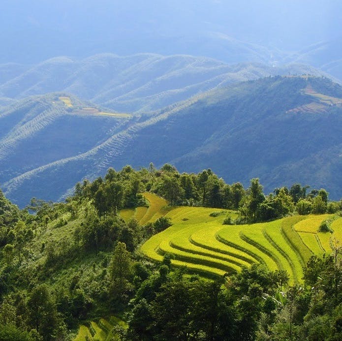
The long descent to Xin Man town offers terrific views of mountains receding into the distance (which is Chinese territory) in shades of purple and blue. The road echoes the course of mountain streams, each one becoming increasingly bloated on the way down as they’re joined by other waterways. During harvest time (September-October) the hillsides are covered in bright yellow rice terraces. Children wave from the roadside, buffalo carry wooden carts full of hay, and men and women are busy working in the fields. It’s a wonderful sight and one that you wouldn’t see if you took the direct route between Bac Ha and Xin Man.

Road DT178 to Xin Man, Ha Giang Province, Vietnam

Descending to Xin Man, distant ridges of Chinese mountains recede to the horizon in shades of purple

[Back to Contents]


SECTION 4

Route: Xin ManHoang Su PhiHa Giang (plus side routes) | Distance: 140km [MAP]

The journey from Xin Man to Ha Giang is spectacular. It follows the course of two rivers: First, the rarely used Road DT178 clings to the valley of the Chay River, heading east then south to join Highway QL2, which leads north along the Lo River towards China, stopping 20km short of the border, at Ha Giang, the provincial capital. There are also several potential side routes.

The Chay River Valley, Ha Giang Province, Vietnam

The spectacular ride between Xin Man, Hoang Su Phi & Ha Giang follows two rivers: the Chay & the Lo

Head east out of Xin Man on Road DT178 as it crosses an impressive bridge linking two high precipices. It’s 100km from Xin Man to the junction with Highway QL2, with the town of Hoang Su Phi in the middle. The entire length is very mountainous, very scenic, and very prone to landslides after heavy rains. Bear this in mind, because, if the weather has been bad, you may be forced to wait while the road is cleared. Either way, progress is quite slow, partly because the road is very narrow, and partly because the scenery is so eye-catching that you’ll want to stop frequently. From Xin Man to Hoang Su Phi (also known at Vinh Quang) Road DT178 glides high above the galloping cascades of the Chay River. However, since several dams have been constructed on the waterway, the river level fluctuates, so that sometimes the road rides high above the water, but at other times the road is flush with the water level. To the north is a wall of mountains, the other side of which is China. It’s a really dramatic ride all the way to Hoang Su Phi, which appears out of the mist.

Riding along the Chay River valley, Road DT178, Hoang Su Phi, Ha Giang

Riding along the narrow & landslide-prone Road DT178, high above the Chay River

The isolated town of Hoang Su Phi sits in a steep valley. Like Xin Man, its streets are incredibly windy and steep. Despite its dramatic location, on a rainy, grey day it can feel very grim indeed. It’s a convenient lunch or overnight stop between Xin Man and Ha Giang. A couple of nhà nghỉ (guest houses) and mini-hotels line the high-street, including Tay Con Linh Hotel (tel: 0219 6558 888) and Hoang An Hotel (tel: 0 219 3731 133), both of which are around 200,000vnd a night. Food is also available at the rice eateries and there’s a lively market.

Lunch in Hoang Su Phi, Ha Giang Province, Vietnam

Hoang Su Phi is an isolated town halfway between Xin Man & QL2: it’s a good lunch or overnight stop

From Hoang Su Phi, it’s possible to attempt a spectacular but challenging mini-loop (the pinkish line), which goes right to the summit of Kiou Leou Ti Mountain. This is a great ride, but it’s a full day in the saddle, and road conditions can be pretty bad: don’t attempt it unless you have plenty of experience, or at least a bike that’s capable in muddy, off-road conditions.

The Kiou Teou Ti Loop, Hoang Su Phi, Ha Giang, Vietnam

The Kiou Leou Ti Loop is a scenic side route from Hoang Su Phi, but conditions can be challenging

From Hoang Su Phi, Road DT177 heads due southeast. If anything, the scenery on this section, all the way to the junction with Highway QL2, is even better than the rest of the road trip. After following a river valley, two high passes – called Heaven’s Gate Pass 1 and 2 – zigzag up through terraced rice and tea plantations. The tea is a special variety with a white flower, called chè shan tuyết (snowy mountain tea). Look out for roadside shacks selling and serving it. The second Heaven’s Gate Pass is the more thrilling of the two. Views over terraced crops, waterfalls, and rivers are majestic. Even in the ghostly mist that often hangs over the pass, it’s a sublime ride. Several regions of Vietnam are famous for their terraced rice fields: this is one of them, and it’s easy to see the attraction.

Rice terraces on Road DT177, Hoang Su Phi, Ha Giang, Vietnam

Between Hoang Su Phi & QL2, two epic passes offer incredible views over terraced rice fields

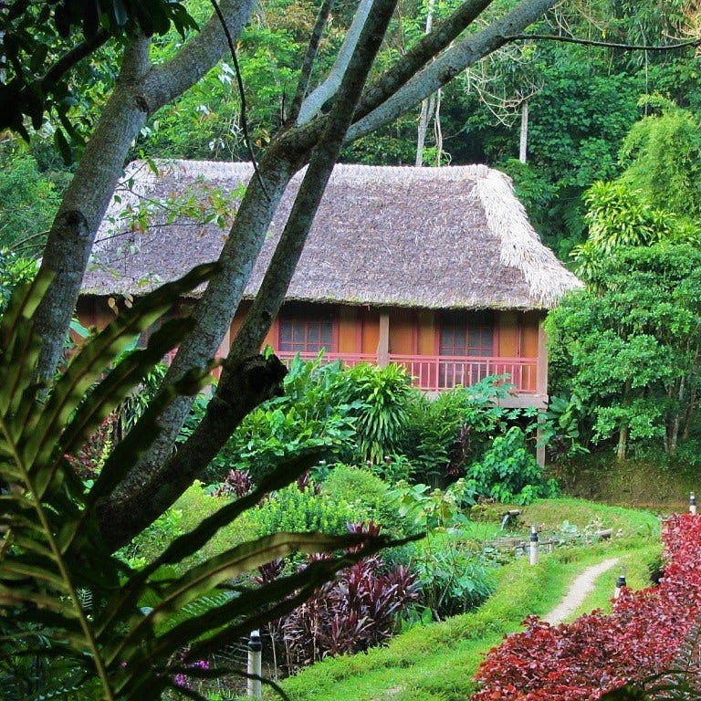
A worthwhile side route (the pinkish line), due west of Road DT177, makes a detour over yet more extraordinary mountain passes, to Thong Nguyen. Here, you can stay in the cosy, comfortable, and remote Panhou Village Resort [BOOK HERE]. Or, if your budget doesn’t stretch that, try the Thong Nguyen Guest House instead (tel: 097 880 17 89; 200,000vnd). The roads here are paved but narrow and potholed. There are many other little lanes that are well worth exploring if you have time.

Crossing the bridge to Panhou Village Resort, Ha Giang, Vietnam

Riding over the wooden bridge to Panhou Village Resort, a scenic side route from Road DT177

Back on Road DT177, after a long and winding descent through marvellous landscape, the road meets Highway QL2. From here it’s a smooth and quick ride along a wide, flat road surface for 40km, due north along the Lo River to Ha Giang.

Rice terraces on Road DT177, Hoang Su Phi, Ha Giang, Vietnam

Yet more fabulous landscapes line Road DT177 as it makes its final descent to meet Highway QL2

Built on the banks of the Lo River, Ha Giang has wide roads, lots of rice eateries, a large market, and lots of accommodation options. For example, River Queen Guest House has clean, new rooms, or try the familiar Western backpacker vibes of Ha Giang Backpacker Hostel, including dorms, or the Vietnamese backpacker vibes of Ong Vang Hostel, which has pod-like rooms by the river, or the fancier budget option of Tiamo Hotel. Other notable cheapies are Kiki’s House Hostel, Bong Ha Giang Hostel, and QT Hostel (owned by the excellent QT Motorbikes). All of the above run from $5-$15 a night, representing very good value for money. Another good choice, especially at the end of this long road trip, is to ‘treat yourself’ to the relative luxury of Truong Xuan Resort, which has bungalows in lush surroundings on the edge of town ($30). Remember, Ha Giang is just the beginning of another great road trip: The Extreme North Loop.

Ha Giang City, northern Vietnam

Ha Giang has lots of food & sleeping options for a night, before heading off on the Extreme North Loop

[Back Top]

RELATED POSTS:


Leave a Comment

Questions, updates and trip reports are all welcome. However, please keep comments polite and on-topic. See commenting etiquette for details.

  1. Nicolas L says:
    March 5, 2024 at 1:34 PM

    Hi all!

    I’m planning a north east trip for April with a friend. We’re looking to do Lao Cai to Hoang Su Phi Lodge in one day via Bac Ha/Xin Man/HSP Dt177 etc…

    Reading the below updates make me re-consider my plans slightly.

    April should be in the at the end of the dry season which should help, but still, if the DT177 is completely torn up, not sure I’m game for 60+ km of bad roads… Could take hours.

    So if anyone has any update on the DT177 road conditions in the coming weeks, I’m all ears :).

    If not, I might try my luck on DT178 then DT197b via the backroads all the way to Hoang Su Phi Lodge.

    Adventure 🙂

    1. Tom says:
      March 6, 2024 at 5:11 AM

      Hi Nicolas,

      I would expect that there will still be road works on DT177 in April 2024, however if the weather is dry it would probably not be so difficult to ride.

      Best,

      Tom

      1. Nicolas says:
        March 6, 2024 at 12:14 AM

        Thanks Tom!

        I’ve found quite a few videos on youtube on the state of DT177, all dated 2023… And boy oh boy ahha.

        I think I’ll decide on the day off, asking locals, checking the weather etc.

        If not dry, this is 60km of hell. 🙂

      2. Nicolas says:
        March 6, 2024 at 7:26 AM

        Oh and as an alternative, what do you think about using the small village roads right in the middle of Hoang Su Phi to reach the lodge. Roads like DT197D / 197E for example?

        Doable? From google maps, they look like small single way ‘slabbed’ paved pathways going through the fields.

        1. Tom says:
          March 8, 2024 at 9:26 AM

          It’s worth a try! If paved and dry then I’m sure it’ll be fine; if wet and muddy then it will be difficult.

          Tom

          1. Damien says:
            March 12, 2024 at 2:06 PM

            Hey Nicolas, i have some news for you!
            Today i went from Sapa to Ha Giang. First i did the DT153. It is in good condition all the way up to Lung Phinh (except for some potholes here and there)
            After that i did the Bac Ha Xin Man road. This one has very few potholes and is in fairly good condition. It is just narrow and there is some gravel on it, watch out in the hairpin turns! The views are amazing tough.
            DT178 all the way to Vinh Quang has pretty similar conditions.

            Then, the DT177…
            The first 20km of it are mostly finished and completely paved or has at least a base layer of asphalt (conrete with a lot of thick gravel) there are about 3 more offroad bits, but they are very doable.

            The next 35 km up to QL2 are not finshed. I must say tough that I think that at least 70-80% of it has a least the base layer. This means that you can comfortably ride at about 30-40kph (slower is even better to enjoy the magnificent views) there are some nasty bits on it, but again, if you dont do it after heavy rainfall almost every bike will pass. I did it with a Honda CB150. The whole length of DT177 road took me about 2.5h.

            1. Tom says:
              March 13, 2024 at 11:10 AM

              Hi Damien,

              Thank you for this valuable and useful update on road conditions, especially DT177.

              Best,

              Tom

            2. Nicolas says:
              March 13, 2024 at 1:27 PM

              That’s amazing news! Thanks a ton for the update both of you.

              Doesn’t seem to be more of a hassle than what I experienced between Ta Xua and Tram Tau on DT112.

              So, yeah, providing it’s dry conditions, I’ll definitely do the DT177. I’ll update this thread in mid April!

              Cheers 🙂

              1. Will says:
                March 21, 2024 at 12:46 AM

                For any cyclists, I just finished that segment on a bicycle, by taking the pinkish line down to Panhou Retreat/Thông Nguyên. The pinkish line was as described, paved with some potholes, and narrow. Very pretty, very manageable.

                After rejoining the DT177 section there are 3-4 areas that will be mud pits if it has rained recently, but they are improving the road daily – I passed upwards of 20 steamrollers flattening the road at various points. There are still areas where the road is quite pitted but it was very doable on a hybrid bicycle.

                1. Tom says:
                  March 24, 2024 at 5:12 AM

                  Hi Will,

                  Thank you for this useful update – it’s good to know. So it sounds like DT177 is not too far from being complete.

                  Best,

                  Tom

  2. Marc says:
    November 24, 2023 at 8:00 AM

    First of all, thanks a lot Tom for the amazing content and community you have created.

    We have driven Ha Giang – Lao Cai over the last few days.
    Couple of updates: from Ha Giang until Yen Binh, QL2 and QL279 are in great condition. Only some bridges on QL279 could need some improvement but all good apart from that.
    The trouble starts driving DT178 up north. It’s a muddy construction site almost all the way up to the Deo Gio pass. I would definitely not recommend anyone driving there after or during rain – unless you want to have a dirt ride and have the right bike for it.
    After the waterfall until Xin Man it’s a nice but careful ride due to lot of curves and crazy truck drivers.
    The (in Google maps unnamed?) road continuing southwest towards Bac Ha is in great condition as well as the actual DT153 turning south towards the city of Bac Ha. We’ll continue to Lao Cai from here but so far, the roads look good. In case the situation worsens, we’ll let the community know.

    1. Tom says:
      November 26, 2023 at 7:45 AM

      Hi Marc,

      Thank you very much for the road updates, it’s really helpful to me and other readers and riders.

      DT178 has been patchy for many years now, so I hope the roadworks will improve conditions within a year or so.

      I hope the rest of your road trip goes well.

      Best,

      Tom

      1. Marc says:
        November 26, 2023 at 12:59 PM

        Yes, let’s hope for it! And – final update – the DT153 from Bac Ha is, apart from the first 5km, also in good condition. AH14/QL14 to Lao Cai is splendid.

  3. Brad says:
    November 9, 2023 at 12:39 PM

    Rode from Ha Giang today 9 Nov 2023 via Q22 and QL279 to turnoff on 197E heading north near Tan Trinh (22.4126635, 104.7212093). 197E is not in great repair but was doable on a Honda Future with a pillion. Our rental guy recommended this as an alternative to DT177. Less than 500m of very slick mud all up. It links up to the SW corner of the pink line in Thong Nguyen and avoids DT177. We were on DT177 for less than 5km (which was smooth, wide unsealed gravel) before joining 197D to Ho Thau. Will attempt DT197D heading west tomorrow!

    1. Tom says:
      November 11, 2023 at 4:31 PM

      Hi Brad,

      Thanks for your trip report and road updates. I hope the rest of the roads are also rideable.

      Best,

      Tom

  4. James says:
    October 28, 2023 at 10:49 AM

    To update on this area which I visited mid-September.
    Speaking to a local in Hoang Su Phi (HSP), DT177 is working to a timetable of being completed at the end of 2024. I passed a short section after it had been raining and the ruts were as deep as my adventure boots.
    DT197 is passable although slow going with potholes and a short section of mud near the damage. Suggest travellers take the small village roads past the Riz on the route up to HSP
    HSP to Xin Man had many landslides with mud on most corners, it had been raining heavily during that time and should be fine from during drier months.

    1. Tom says:
      October 31, 2023 at 12:23 PM

      Hi James,

      Thanks for the updates – very useful. Looks like we’ll have to wait until 2024 for DT177 to be finished then!

      Best,

      Tom

  5. Marie-France says:
    October 25, 2023 at 11:01 AM

    Hello!

    For those who are looking for fresh informations about the road to go to Thông Nguyên, I just arrived from there, so I will share, as it’s difficult to find new info.

    To get there, I asked a Vietnamese friend that came back from Thông Nguyên which road was the best, she told me to take the 197E starting at the junction with QL279 next to the market of Tân Trinh. The road is narrow, steep and full of big holes and unpaved patches. A lot of trucks passing by really quickly, etc. It’s bumpy, it would probably be better with a proper motorbike, but with a scooter, it was unpleasant (not to say dangerous) to get there. And as it goes up a lot, I was thinking that the way down would be worst…

    Before leaving, I asked the owner of the homestay where I stayed if the road DT177 was still under construction. He said that the road is under construction from Xin Man to Tan Quang. And by construction, it means that there is no proper road at the moment. Apparently, it was raining too much lately, so they couldn’t work… But he told me to take the DT177 anyway, as it would be faster than the 197E. So I gave it a try… To get to the DT177, the road is bumpy, but fine. The DT177 is a mud track at the moment. I was lucky, it was mostly dry when I was there, but it’s just sand, mud, lots of rocks that makes the road more bumpy, big holes and a lot of dust. There is no pave sections at all. It took me a long time to get to Tan Quang, but I made it safely. Again, with a motorbike it would have been better, but even, in some parts, locals were having a hard time to manage to pass.

    So hopefully, the road will be pave soon! If you decide to go, be careful! 😊

    Take care
    Marie-France

    1. Tom says:
      October 26, 2023 at 8:03 AM

      Hi Marie-France,

      Thank you for these important and helpful road updates – it is very useful to me and other readers and riders.

      It sounds like the construction on DT177 will last for another year at least, but after that it will be a lovely ride once again.

      It’s such a beautiful area, I hope road conditions with improve soon.

      I think it seems that for the next 6 months at least it is wise to avoid the road in wet or damp conditions, and even when dry to be very careful indeed.

      Best,

      Tom

  6. Blake Respini says:
    August 21, 2023 at 2:26 AM

    Hi, I rode from Ha Giang to Lao Cai during the first week of August 2023, following all the red and pink routes. Great ride; however, potential riders should be aware that the main road from Quang Binh to Su Phi was under major construction and pretty bad for riding, not only due to the deeps ruts caused by heavy machinery but also to the constant eye sore of the construction itself. We took the pink cut off through Hoang Nguyen to get of the main road and hat road was beautiful and smoother, and despite being a little longer than the main road, was probably quicker and certainly more pleasant.

    1. Tom says:
      August 21, 2023 at 2:35 AM

      Hi Blake,

      Thank you very much for this important update. Can you please clarify that the construction you are referring to is on the road between Tan Quang and Hoang Su Phi (DT177) or between Quang Binh and Hoang Su Phi (DT178)?

      Best,

      Tom

      1. Blake Respini says:
        August 21, 2023 at 3:24 AM

        So sorry for the error. The construction is on the entire distance from Tan Quang to Hoand Su Phi.

        1. Tom says:
          August 21, 2023 at 6:20 AM

          That’s great, thank you for clarifying!

          Best,

          Tom

  7. Brendon Lim says:
    May 31, 2023 at 9:44 AM

    Tay Con Linh Hotel at Hoang Su Phi is 250k VND.
    Room is large and clean with a balcony.
    Bathroom cleanliness is about average.
    Room has a minibar fridge ideal for the drinks in the hot and humid summer Vietnam is facing now.

    1. Tom says:
      May 31, 2023 at 12:05 PM

      Hi Brendon,

      Thanks for the update – sounds like quite a good deal! 🙂

      Best,

      Tom

  8. Brendon Lim says:
    May 31, 2023 at 5:03 AM

    This morning (31st May 2023) I took the DT177 from Bac Quang to Hoang Su Phi.
    The road is muddy in many sections and if it was raining it would be a mud bath.

    1. Tom says:
      May 31, 2023 at 12:04 PM

      Hi Brendon,

      Thank you for the update. I hope they’ll finish repaving that route soon – it’s such a beautiful area.

      Best,

      Tom

  9. Mike says:
    January 18, 2023 at 12:43 PM

    Hi !

    First off all thank you very much for this content it’s really help us to prepare the trip

    I have a question, we would follow the blue road from Sapa to Bac Ha one night in Bac Ha, and from Bac Ha to Ha Giang
    You mention we should take the road from Moung Khoung early to enjoy the road to Bac Ha, when I look on google map the road is quit short and could be done in an afternoon. do you recommend to take the time because the road is beautiful or you think Google map is not relevant ?

    We will arrive by train at lao Cai 5AM, take the road to Sapa
    Leave Sapa around 9/10am ( time to walk and enjoy the view)
    Arriving at Murong Khuong around 13PM (short break)
    Leave Murong Khuong at 13:30PM
    Arrive at Si Ma Cai around 4.30PM
    Then to Bac Ha arriving at 6PM

    Do you think this road could be done ? (in case on problem with the motorbike or difficult roads I took care to ad 30min to 1hour every stop)
    Maybe it is to short to do it in one day, thanks agains for the web site and your travel experiences
    Mike

    1. Tom says:
      January 21, 2023 at 11:11 AM

      Hi Mike,

      In the northern mountains many of the roads are quite small and very windy, so they can take longer to ride than you expect. Also, sometimes road works, or landslides, or bad road conditions might slow you down, too. On a windy, mountainous road in northern Vietnam, your average speed might only be 30kmph. But, if the weather and the road conditions are good, then you can ride between Sapa and Bac Ha on the blue route in one day following your schedule without a problem. But remember, the scenery is so good that you will probably want to stop to look at it a lot! 🙂

      Best,

      Tom

  10. Việt says:
    October 16, 2022 at 4:55 PM

    Why you don’t try to pass Y Tý, from Sapa go to Y Tý then Y Tý back to Lào Cai.

    1. Tom says:
      October 17, 2022 at 12:12 PM

      Hi Việt,

      Yes, I’ve put that route in a different guide on this page. But there are some rough roads on the Y Ty route and also foreign visitors aren’t allowed to stay overnight at the moment unless they have a permit.

      Best,

      Tom

  11. Pat says:
    September 14, 2022 at 4:16 PM

    Hi Tom.

    So I pick apiece this section for a direct route from Lao Cai to Ha Giang today. Yes 1 day’s riding (250km) but I was feeling up for it.
    Firstly, what an amazing day’s riding. The AH14 was smooth riding all the way along to the turning off for Bac Ha. Once I was on the DT153, the stunning scenery soon appeared all the way until Xin Man. Stopping at the panorama coffee place to take it in. I don’t remember any of this road being too bad.
    Then the drive on the DT178 towards Thac Tien Waterfall was just a dream also. Absolutely breathtaking. And thanks so much for the recommendation. A lovely pit stop. (There’s always a gorgeous looking Homestay about 5km before the waterfall I would’ve enquired about had it been later in the day). The road 5km EACH side of the waterfall is a little beaten up but totally worth the price on today’s riding. Once out of hillsides and onto QL279 it was awful until Viet Quang but the 60km left to Ha Giang was a dreamy smooth road to finish up a long but very beautiful and memorable day 🙂

    1. Tom says:
      September 15, 2022 at 6:59 AM

      Hi Pat,

      Thanks for your trip report and updates on road conditions.

      I’m glad you enjoyed this route. It’s a shame about QL279 – it’s been in bad condition for years now!

      But it’s great to hear that the other roads are in decent condition and that the scenery is still fantastic.

      Best,

      Tom

  12. Lucas Walker says:
    August 17, 2022 at 11:56 AM

    The DT177 south of Hoang Su Phi is mostly torn up at the moment with roadworks. Very bad conditions and long delays! Once it’s finished this will be a spectacular route.

    1. Tom says:
      August 19, 2022 at 4:22 AM

      Hi Lucas,

      Thanks for the useful update. That’s a shame, but as you say, when it’s finished it’ll be great.

      Best,

      Tom

      1. Patryk says:
        January 22, 2023 at 10:11 AM

        Greetings, I’m considering travelling on this road in the next few days and wondering how to find out if the road has been completed or is in a mostly decent condition 5 months after Lucas’ info about the roadworks. Any leads? Or just give it a bash?

        1. Tom says:
          January 23, 2023 at 6:08 AM

          Hi Patryk,

          It’s difficult to say – that was 6 months ago so they must have made progress on the road works by now. However, I haven’t heard any updates since then.

          It’s best to ask people as you go – you’ll meet riders going in the opposite direction who you can ask, or ask locals, such as at your hotels or guest houses.

          Best,

          Tom

        2. Neil says:
          March 6, 2023 at 6:56 AM

          How was it? Considering doing the dt177 too

          1. Tom says:
            March 7, 2023 at 3:45 AM

            Hi Neil,

            The report about road construction on DT177 south of Hoang Su Phi was 6 months ago, so I would expect there has been some progress made. However, that is a very windy stretch of road so I also imagine it might take a long time to pave. I think the best thing to do would be to ask when you are in the general area. Also, if you do ride it, please report back here with up dates on conditions. Thanks.

            Best,

            Tom

  13. Miguel says:
    July 29, 2022 at 2:59 AM

    DO NOT TRY THE SIDE ROUTE (PINK, IT IS A LOOP) FROM HOANG SU PHI.
    At least counterclockwise.
    I will give details later on.
    I broke my Honda XR 150 clutch because of the extremely bad path conditions. I am an experienced rider still I found it extremely difficult and exhausting. I almost reached Kiou Leou Ti, I broke 3 Km before this point. Luckily 50 meters ahead I got to find a man and his son house, because it was getting really dark and it started raining as well. It seems that the path gets much better after this point. I will let you know later on.

    1. Tom says:
      July 30, 2022 at 12:07 PM

      Hi Miguel,

      Thanks for your comment.

      Yes, it’s a very rough road at points. Sorry to hear you had problems on this loop. The road connections there are always changing, especially during the rainy season.

      Best,

      Tom

  14. sacha says:
    October 16, 2021 at 10:58 AM

    Hi Tom,

    Great info here! I plan to tour this area once things open up. Do you know if its possible to rent a motorbike in sapa then drop it off in ha giang? I have no experience riding a motorbike, so I figure its best to do it away from the cities. I wouldn’t be renting in Hanoi because I’d be too afraid of driving there.

    1. Tom says:
      October 18, 2021 at 4:02 AM

      Hi Sacha,

      For motorbike rental try contacting Flamingo Travel (they have an office in Lao Cai, near Sapa) and QT Motorbikes (they are based in Ha Giang). In general, it can be difficult to arrange one-way rental like that, but contact them to ask and perhaps they can work something out for you.

      If this is your first motorbike trip, you’d need to take it very slowly and get some days of practice in before you head off, because this route is very mountainous and, although the roads are mostly paved, they can be muddy and dangerous if the weather has been bad. It’s an utterly beautiful ride, just take it easy and be safe.

      I hope this helps,

      Tom

  15. Stuart says:
    December 6, 2020 at 1:01 PM

    Great blog ?

    Have you explored Amy of the side routes onto China?

    1. Tom says:
      December 7, 2020 at 4:18 PM

      Thanks, Stuart.

      There are lots of roads to China: some are official borders and some are ‘unofficial’. But often they are ‘sensitive areas’ and difficult to explore freely on a motorbike without being stopped by officials.

      Tom

  16. Stu says:
    November 23, 2020 at 2:39 AM

    Hi,

    We tried to ride 197C from Vinh Quang to Ha Giang yesterday. We were stopped by a guard about two hours in and had to turn around.

    A good but challenging day trip. Google maps was often wrong and phone signal was intermittent.

    1. Tom says:
      November 23, 2020 at 3:12 AM

      Hi Stu,

      Thanks for the update. Sorry to hear you were turned back.

      Tom

  17. Marc-andre Gosselin says:
    December 2, 2019 at 4:21 PM

    I took the 197c today from Ban pho direction Po Lung. The paved road stop a little after Ban Pho and then you are on a dirth road for the next 20km or so. I drove the xc150 with no previous experience off road. I have to say that it was the most stupid decision I made. After going thru the difficult first part going up hill, I did not wanted to go back because it was hard enough to get there already. I was alone and dropped my bike a couple times because of wet dirt and step hill. About half way thru, I wasn’t sure If I was going to make it alive. At some point, the xc150 could barely make it. There is at least 15 place where losing balance would end up in a fatal drop. I discourage anyone to attempt this “”road”” unless you have good experience driving off road and are not traveling alone. There is also nothing special to see in the off road portion. To get an impressive view over the rice field, its better going up from Vinh Quang to Then Chu Phin and down as a day trip than taking the risk all the way to Ban Pho and or the other way around. No joke, I barely made it today, bended the rear brake lever and almost broke my foot that got stuck under the bike that felt on me once : ( 197c is not worth one’s life.

    1. Tom says:
      December 2, 2019 at 4:36 PM

      Hi Marc-andre,

      Thanks for sharing your experience of road 197C. I agree: it is certainly not worth the risk. Many people are tempted by this road because it looks like a good shortcut, but when conditions are that difficult it’s definitely not an option. I know a few serious off-road riders who enjoy this route, but they are very experienced.

      Thanks again, and I hope you and your bike are OK.

      Tom

  18. Sam says:
    September 4, 2019 at 9:54 AM

    Just tried the Kiou Leou Ti loop in clockwise direction, ended up turning around about 8kms from the summit because the earth was soft with too high of a gradient. Was even too much for the Honda XR. Was able to make it up a few of the steep sections by throttling while off the bike (the weight of my bag strapped to the back plus my own weight was making me sink in the dirt), but cut my losses when it kept getting worse and am now enjoying a beer beer the Trieu Vien homestay.
    Any idea what the climb is like if you go counter clockwise?
    Thanks!
    Also this website has made this and my last trip through Vietnam so much easier. Thank you so much!

    1. Tom says:
      September 5, 2019 at 2:33 AM

      Hi Sam,

      Thanks for the update about the conditions on the Kiou Leou Loop.

      I don’t know for sure if it’s any better from the other direction at the moment, but I have heard recent reports that conditions are OK. I can’t vouch for that though, because it depends on weather and landslides etc.

      Please leave an update here if you do attempt it.

      Thanks,

      Tom

  19. Nina says:
    July 7, 2019 at 11:09 AM

    Thanks for the great article! Do you know if there is a bus from Ha Giang back to Hanoi on which we can bring our motorbikes?

    1. Tom says:
      July 8, 2019 at 8:11 AM

      Hi Nina,

      This is a commonly asked question: I don’t know for sure, because I have never personally sent my motorbike by bus between Ha Giang and Hanoi, but I have heard of several people who have. I suggest asking at your accommodation in Ha Giang for more details. If you do it, please share the information here.

      Thanks,

      Tom

  20. sergi says:
    June 9, 2019 at 6:37 AM

    Hey guys! Just to share some information from road 197C which connects Po Lung with Ban Pho. Me and my girlfriend did it with a Honda Wave and a Yamaha Sirius. It’s beautiful, how ever it was a really stupid idea – there are 20 km where the road is in really bad condition. Actually not, because you can’t call it a road- it’s more like a hike (literally!!!). We have been lucky- the weather was great …

    Only do it if you have a proper bike for off-road circumstances (the three local bikes which we met on the way were Honda Win) and if you are really out for heavy adventure. And also you should have a good Level of Fitness, since you need to support the bike a lot with your /body – heavy luggage might be a pain in the neck.

    No chance that cars can pass there … sometimes the „road“ has less than half a meter width.

    1. Tom says:
      June 9, 2019 at 6:43 AM

      Hi Sergi,

      Thanks for the great update and information. It’s a shame that ‘normal’ bikes can’t pass road 197C yet, but as you say it’s a great adventure if you’ve got the right bike for it.

      Thanks again,

      Tom

  21. DaveSuperTramp says:
    March 9, 2019 at 3:54 AM

    Hello man, I am on the road in northern Vietnam, doing some epic back roads close to the chinese border, between rain, fog, clouds and amazing locals. Tomorrow I want to take the road 197c that connect the city of Thanh Thuy with Vinh Quang. I am asking to some locals but nobody can tell me the condition of this road and can find nothing online. Do you know something about?
    When I have time I will write another post with updates about the condition of some back roads you have mentioned in the other posts, some of these are really something specials!

    1. Tom says:
      March 9, 2019 at 1:27 PM

      Hi Dave,

      All the reports I’ve heard about that road have been that it’s in pretty bad condition. However, the last time I heard anything about it was at least a few months ago. I tried it once, but was encouraged to turn back because locals said the condition was too bad. But it does look like a very enticing route to take, especially if you have a bike that can handle mud and bumps. There is also the possibility of encounters with officials on that road, because it’s so close to the Chinese border.

      Anyway, if you do try it, please share your experience here.

      Good luck,

      Tom

    2. ChantalMtl says:
      March 14, 2019 at 7:56 AM

      We will be leaving from Ha Giang and planning to take the DT177 then the DT178 to Xin Man (Coc Pai), can you report on the road conditions?

      Thank You

      1. Tom says:
        March 14, 2019 at 9:23 AM

        Hi,

        I don’t have any new information about the conditions on those roads, but they are always prone to landslides after heavy rain. I would check the forecast: if it’s been dry recently you should be fine, if wet then you may have problems. There’s also the possibility of roads works on those roads – because when the landslides hit, they damage the road surface which then must be repaired.

        Good luck,

        Tom

        1. ChantalMtl says:
          March 18, 2019 at 3:17 AM

          Just returned. Did the loop from Ha Giang. To Bac Ha market we took que QL2 to the QT 177. Scenery amazing and road mostly very good to good. From Su Phi to Xin Man (Cuc Pai) also pretty good. A few km on sandy roads. We had a late start from Ha Giang, around 10 am, stopped for so many pics, arrived in Xin Man around 5 pm. No rain, even with rain I would say this part would be very doable. Next day headed to Thac Tien waterfalls and headed back to Win Man to take the small road to Bac Ha. About 10 km of bad road. With rain it would be challenging, on dry road, pretty technical but doable (I don’t have a lot of experience riding and one of our riding buddies it was her first time). Left Win Man at about 10 am and arrived in Bac Ha around 5 pm. So worth it if you have time. Left Bac Ha market at around 10 a.m. and took your red route – Pho Rang, QL 279, QL 2 back to Ha Giang. In the morning full fog and rain, cleared up as we went down the mountain then just cloudy. Did 12 km extra due to missed turned so did 200 km. I’d say about 10 km total of really bad road but the rest excellent. Last part (about 60KM), on highway with trucks but few turns so good speed. Arrived at 4:30 in Ha Giang, no stop for lunch. Scenery nothing like the way there but much quicker.

          Thank you so much for your blog, wouldn’t have done it without you and surprisingly we found it even more beautiful than the loop. No tourists, 3 women riding attracted quite a bit of attention. You need a semi automatic. Thanks again and keep posting!

          1. Tom says:
            March 18, 2019 at 3:27 AM

            Hi Chantal,

            Thank you for sharing your experience of this route – sounds like you had a good time and that the roads are in pretty OK condition at the moment, so that’s great.

            I agree that semi-automatics are preferable but they’re not essential for this route – I’ve ridden it many times, all on an automatic.

            Thanks,

            Tom

  22. Roberto says:
    November 28, 2018 at 1:29 AM

    I arrived in Ha Giang and, man, what a ride.

    A few updates:
    1. The Sunday hotel could have changed name, because at the exact location there’s a guest house with a Vietnamese name. However, there’s also the Saturday hotel right across the street and some good hostels to crash for a night.

    2. If you plan to spend a night in Sapa before starting the trip, beware of the road going down to Ta Van, where most of the homestays are, because it’s IN VERY BAD SHAPE. I had the brillant idea to take it under pouring rain and took me almost an hour with motorbikes and cars sliding all over.

    3. Right beside Ngoc Son motel in Xin Man there’s a rice eatery. Don’t eat there. There is a nice Pho place at 5mins walking down toward the market. You will see it on your left, a wooden hut a bit hidden on a tiny path going uphill. In the morning it was the only place plenty of locals.

    Not so important updates, but I hope they can be of help.

    1. Tom says:
      November 28, 2018 at 7:09 PM

      Hi Roberto,

      Thanks for the updates. I appreciate it.

      Tom

  23. Hugo says:
    November 1, 2018 at 10:46 AM

    Hi Tom, commenting on your website again, following the news out of Ha Giang. Switching up my trip and heading to Lao Cai instead. In your opinion, which is better ? East doing Y Ty, Lai Chau, Sin Ho and looping back to Lao Cai. Or doing a Lao Cai – Hoang Su Phi loop towards the West ? I’m sure both are great and will do both at some point but my friend will only be here 1 week so want to pick the best one ! Thanks once again for all your help and amazing website.

    1. Tom says:
      November 1, 2018 at 12:36 PM

      Hi Hugo,

      Well, considering that much of the Hoang Su Phi loop is in Ha Giang Province, I think it might be best to stick to Sapa and Lau Chau area.

      Note that the road conditions on the Y Ty Loop are still pretty rough from about 15km south of Y Ty all the way north until you reach the Chinese border. Also note that on the Sin Ho Loop the road from Lai Chau to Sin Ho was reported closed a couple of months ago for clearing of landslides. If it’s still closed they’ll be a sign at the entrance to the road from Lai Chau.

      I hope this helps,

      Tom

      1. Hugo says:
        November 1, 2018 at 2:59 PM

        Thanks for your comments. True, I’ll stick to the east this time. I’ll update on road conditions next week ! Thanks again.

  24. Tom says:
    September 19, 2018 at 2:31 PM

    Hey Tom,

    First of all, your page is the killer! We are 2 weeks in on our 2 month road trip through Vietnam and we almost exclusively use your page for planning since it’s so detailed. I can only imagine how much effort you must have put into this page. Much appreciated! Today we drove the Borders and Backroads – Sapa to Ha Giang section 4, in opposite direction (starting from Ha Giang), we skipped section 3 and drove the shortcut (red road on your map) to Bac Ha. The scenery was beautiful and quite diverse. We enjoyed it a lot.
    Update on the road: the part from Hoang Su Phi to Coc Pai had probably 20 or more landslides. All were cleared but in some parts there was ankle deep puddles/mud. We (2 people and a large backpack on a Honda XR 150cc) had no problems to cross them and so did several Vietnamese on their scooters. Also the first 15 km or so of the red road are quite terrible (seemed to be no progress in the 3 years from your first post). It’s essentially driving up a steep gravel road sometimes with muddy sections and riddled with potholes. It’s not a question of driving around potholes but more of which one you want to drive through. Probably took us 1 hour driving 15 kph in first gear.
    We had a lot of fun but it’s definitely not a road for beginners who just started in Vietnam (have years of motorbike driving + offroad experience). Seems to be also very difficult on scooters. Seen few Vietnamese pushing up theirs in the very tricky sections, which you don’t see that often.
    Cheers,
    Polish Tom

    All other roads we took so far were more or less okay (to Ba Be lakes, to Cao Bang, to Meo Vac along the Chinese Border, Ha Giang loop).

    1. Tom says:
      September 19, 2018 at 2:44 PM

      Hi Tom,

      Thank you. Great to hear your road trip is going well.

      Thanks for the updates – really good to know. I’m just about to update this guide, based on my last trip there – at that time the road conditions were pretty similar as you describe them.

      I hope that things continue to go well for the rest of your trip.

      Tom

      1. Tom says:
        September 22, 2018 at 4:00 AM

        Thanks, mate.
        Cheers.

  25. Giovanni says:
    September 13, 2018 at 3:02 AM

    Hi Tom, you’re doing an amazing job with this site, really. Now that I saw your support page I’d really love to support you somehow.

    I’ll be in the north for a solo motorbike trip in the first days of november, i would like to do hanoi-sapa, sapa-cao bang, through your routes (boarders & back roads and the high roads), and then back to hanoi.
    Is the road easy to follow without getting lost or do i need to buy a map of those places? (i’m assuming there will be no phone signal for google maps)
    Do you suggest to book the hostels for the night or is it easy to find a bed?
    Last but not least, is it easy to find gasoline during the trip?

    Thank you very much for your time!

    1. Tom says:
      September 14, 2018 at 1:49 AM

      Hi Giovanni,

      If you buy a local SIM card (they’re cheap) and make sure it’s the Viettel brand (which gets good coverage in the mountains) then you should be able to access data most of the time you are on the road. I’ve written more about maps here.

      Some sections of those roads aren’t that easy to follow, but it’s just a case of map-checking and using your initiative and general sense of direction. You should be fine.

      Gas stations are fairly regular on that route – they’ll be a gas station or gas sold in bottles by the side of the road in most villages – but don’t let your tank run too low: when you’re a third full, fill up at the next opportunity.

      Tom

      1. Giovanni says:
        September 14, 2018 at 11:24 PM

        Thank you very much! I’m using your website to organize all of my month in Vietnam.. keep it up, it’s great!

  26. Peter says:
    July 5, 2018 at 9:54 AM

    I cycled the Ha Giang loop last year, thanks for all the information, it was very helpfull. I plan to go back this year and cycle from Cao Bang to Laos and the Thai border. I saw that there is a small road from Ha Giang departing fro QL 2 to Hoang Su Pi DT197 C. Do you know if this road along the Chinese border is ridable.

    1. Tom says:
      July 5, 2018 at 11:45 AM

      Hi Peter,

      As far as I know, that road is still in bad condition (only suitable for dirt bikes and 4x4s), but it’s always worth asking around at the time, because roads are upgraded and opened all the time in Vietnam.

      If you do take it, please let me know how it goes.

      Tom

  27. Ingrid says:
    March 9, 2018 at 9:21 PM

    Beste Tom,
    is er een loop die zowel Pu Luong, Mai Chau, Sapa tot in Ha giang doet?
    Is er een drop-off systeem? zoiets gelezen over bij Rent a bike vn.com maar is vooral voor Noord Zuid road trips.

    1. Tom says:
      March 10, 2018 at 1:15 AM

      Hi Ingrid,

      You can link the Mai Chau-Pu Luong area (in my Limestone Loop guide) with Sapa by taking either road QL6 via Son La or QL32 via Nghia Lo (but it’s a long ride), then from Sapa you can follow the route on this page to get to Ha Giang.

      Rent a Bike Vietnam and other rental companies should be able to arrange pick up or drop off at Lao Cai (Sapa) but I’m not sure about other locations.

      I hope this helps,

      Tom

  28. Nishat Saleri says:
    October 16, 2017 at 6:05 AM

    Hi Tom,
    Your guides are excellent and so many options to chose from!
    We are finally settling on Ha Giang to Sapa but needed some advice. Is it possible to take a bus to Ha Giang from Hanoi, rent a bike there and do a one-way trip to Sapa, leave the bike in Sapa and come back by train to Hanoi? If not, and we have to return the bike from where we have rented it then what you suggest would be the best way to do this? We have around 6 days for this trip. It’s our first time and we have no clue how it works!!
    Look forward to your reply.
    Nishat

    1. Tom says:
      October 17, 2017 at 12:10 AM

      Hi Nishat,

      Yes, there are buses from Hanoi to Ha Giang – they leave quite regularly and are comfortable.

      It might be a bit difficult to rent a bike from Ha Giang and then return it in Sapa. Try contacting QT Motorbikes in Ha Giang to ask if they can do it or not. But if that’s not possible just do a loop instead. Ha Giang is a very scenic area and there are a lot of great roads and great things to see and do.

      With 6 days I suggest you take the Ha Giang Extreme North Loop and then (if you still have time) ride from Ha Giang up to Hoang Su Phi on road DT177 (as outlined on this page in the Borders & Backroads route) and back again to Ha Giang. This would make a fantastic loop for six days.

      As all of my northern route guides are currently being updated, I suggest that you ask QT Motorbikes for some additional route advice too – there have an excellent map and know the area very well. You can mention Vietnam Coracle if you like, they know me.

      As an extension to the original Ha Giang Extreme North Loop in my guide, try taking road DT176 south of Yen Minh to Du Gia where there are a couple of good homestays – this is a very scenic little side trip and well worth it.

      I hope this helps,

      Tom

  29. Taylor says:
    October 10, 2017 at 9:14 AM

    Hi Tom!

    Finishing up the NE loop and loving every second of it. Thanks for all the great info! We are currently in Cao bang and going to head to Ba Be lake for a day or 2. Then hoping to link up with your guide from Sapa to Ha Giang. Any suggestions on a good route to link them up? Thinking of starting south of Ha Giang so we don’t have to backtrack up North. But if you think it’s better to head up to Ha Giang, I’m all for it! Thanks again,
    -Taylor

    1. Tom says:
      October 11, 2017 at 1:12 AM

      Hi Taylor,

      I’m actually in Ba Be at the moment, but leaving today. It’s beautiful here, but been raining for the last 24 hours. Try Hai Dang Homestay or Mr Linh’s if you’re looking for a good place to stay.

      From Ba Be you should definitely head north to Ha Giang first and then west on the borders route to Sapa.

      From Ba Be to Ha Giang you can take road DT212 north to join QL34 just east of Tinh Tuc mining town. Then take QL34 west to Bao Lac and head north towards Meo Vac on QL4C at Bao Lam (a few kilometres of QL4C are in rough shape but the second half is good).

      Alternatively, you could stay on QL34 all the way to Na Sai from where you can head north on DT176 to Du Gia, which is a scenic road (in OK condition). Du Gia has a few good homestays in a great valley. From Du Gia DT176 continues on an incredibly scenic route to the Mau Due crossroads where you can either turn east toward Meo Van or west toward Yen Minh and Ha Giang City.

      You can’t really take QL34 all the way to Ha Giang city at the moment because the last bit of road is in really bad shape, in fact QL34 in general is prone to landslides that can slow you right down.

      Then from Ha Giang city follow my Borders route across to Muong Khuong via Hoang Su Phi and Xin Man. You can now take the red route in my map between Xin Man and Bac Ha – the first 10km is very rough (but passable), but after that it’s in good condition.

      I’ve just re-ridden all of these roads in order to update my guides, but I haven’t gotten around to rewriting them yet. The roads are all fine but still often subject to landslides, so be careful and give yourself plenty of time.

      I hope this helps,

      Tom

      1. Taylor says:
        October 11, 2017 at 3:14 AM

        Ah too bad we are missing you at Ba Be lake, I definitely owe you a few drinks! Thanks for all the updates and awesome info, you are making this the best trip ever!

        1. Taylor says:
          October 13, 2017 at 9:39 AM

          One more question…we have 13 days left on our Visa and I keep reading how the government has put a hold on extensions. So we are thinking of crossing into Laos at Na Meo. Have you crossed or have any suggestions?

          1. Tom says:
            October 14, 2017 at 2:38 AM

            Hi Taylor,

            I have been to the Na Meo border post several times but have never crossed it. However, other readers have written to say they have done it and haven’t had any problems. You should be able to get a Lao visa on arrival at the border post – I think it’s around $25-$40. But I can’t personally vouch for this as I’ve never done it.

            Good luck,

            Tom

  30. Xaviera says:
    April 27, 2017 at 3:40 PM

    Hello!
    In part 4, you talk about Hraven’s gate pass, on the road Ql2….isn’t the heaven’s gate pass on the 4 near Tam Som?

    Thank you!

    1. Tom says:
      April 27, 2017 at 4:27 PM

      Hi Xaviera,

      No, that’s a different ‘Heaven’s Gate Pass’ – there are a few of them in Vietnam 🙂

      Tom

  31. Flip says:
    February 24, 2017 at 8:01 AM

    Hi there. Great resource.

    How big of a mission is it to rent the bike in Hanoi and ship on the train? Is it worth the effort for 7 days of exploring or better to take the train and rent in the main towns?

    Thanks
    Flip

    1. Tom says:
      February 24, 2017 at 8:09 AM

      Hi Flip,

      It shouldn’t be too much of a mission to do that: contact the motorbike rental companies in Hanoi in advance – they will probably be able to advise you about putting your bike on the train. Try Rent a Bike Vietnam, Tigit Motorbikes, and Style Motorbikes – they all have offices in Hanoi and are all reputable rental companies. There are links to all three of them in the right sidebar and bottom of all my pages. You can mention Vietnam Coracle if you like, they know me.

      I hope this helps,

      Tom

    2. Flip says:
      February 24, 2017 at 8:23 AM

      And another q. If you had to cut one option between Sapa and Ha Giang for a firat time solo visit to the North where would your heart be?

      1. Tom says:
        February 24, 2017 at 9:27 AM

        You could skip the first section of the route on this page – from Sapa to Muong Khuong. Instead, head straight to Bac Ha via AH14 (also marked QL70) and on to DT153.

        Tom

  32. Kimmy says:
    February 8, 2017 at 5:33 PM

    Hi Tom,

    Love all your articles here! My fiance and I will be in the northern Vietnan area for 5 days in March. We are hoping to take the overnight train from Hanoi to Lao Cai, and renting motorbikes there. We will be in Sapa for 2 nights (motorbiking around) and then plan on (hopefully) doing a 3 day -2 night loop ending up in Lao Cai. I REALLY wanted to get to Ha Giang but I’m not sure if that’s possible. I saw you had a Sapa 2-3 loop as well, although it doesn’t look as stunning at Ha Giang.

    I would love to know your thoughts!

    1. Tom says:
      February 9, 2017 at 1:31 AM

      Hi Kimmy,

      Both Ha Giang and Sapa routes are spectacular. If you wanted to do that Ha Giang loop you would have to spend one day riding there, one day riding the loop, and one day riding back to Sapa again. This is doable but not really a good idea. So, yes, I would suggest doing the Sapa-Sin loop over 2 days instead and then maybe add on the Mu Cang Chai route for a day too. This is a great ride, and it will be more relaxing than trying to get all the way to Ha Giang and back again.

      I hope this helps,

      Tom

      1. Kimmy says:
        February 10, 2017 at 2:42 PM

        Thank you for getting back to me so quickly! I think I agree that we just don’t have enough time to do Ha Giang this time around. I will look up Mu Cang Chai and Sapa-Sin Loop and just staying in that area.

        Are the road typically good in mid March? I suspect the rain won’t come for a few months at least!

        Would you recommend renting bikes in Lao Cai or Sapa? How did you deal with the passport situation (giving to the bike rental company or paying a deposit?)

        Thanks again!
        Kimmy

        1. Tom says:
          February 11, 2017 at 2:21 PM

          Hi Kimmy,

          March/April is generally one of the best times to visit that area, however, it’s a mountainous region and the weather is always fairly unpredictable. Road conditions in the northern mountains are pretty good but changeable depending on the weather – if there’s been a lot of rain then landslides can block roads for hours or even days.

          I would recommend renting bikes in Hanoi and then putting them on the train to lao Cai. Style Motorbikes, Rent a Bike Vietnam, and Tigit Motorbikes are all reputable rental companies with offices in Hanoi – there are links to all three of them in the right sidebar and bottom of all my pages. You can mention Vietnam Coracle if you like, they know me. If not, then renting a motorbike in Sapa would be easier than in lao Cai. You won’t need to leave your passport with any of the recommended agencies, but in Sapa you will probably have to give them a copy of your passport or some collateral.

          I hope this helps,

          Tom

          1. Kimmy says:
            February 16, 2017 at 2:50 PM

            Excellent, thank you! I will reach out to those rental places. Our trip was just extended by 3 days so we now have 5 days (7 including Sapa) for motorbiking around. Is that enough to get over the Ha Giang? Thank you SO much for taking to the time to answer my questions!

            1. Tom says:
              February 16, 2017 at 3:57 PM

              Hi Kimmy,

              Yes, if you ride from Sapa to Ha Giang and back again on the most direct route, and spend 2 days doing the Ha Giang Loop, you’ll have enough time. But bear in mind that it would be quite a lot of riding in a relatively short space of time. However, if you’re used to riding longish distances you’ll be fine.

              Tom

  33. Antek M. says:
    October 16, 2016 at 1:02 PM

    Road from Pha Long is currently in pretty bad shape – exactly some 20km starting from the top of the mountain above Pha Long until the river. As soon as you cross the bridge, road becomes great again and stays so until Simacai and Bac Ha.
    Nevertheless it’s very beautiful ride and definitely worth the effort it takes

    1. Tom says:
      October 17, 2016 at 2:00 AM

      Hi Antek,

      Thanks for the update. That’s good information to be aware of. I hope they fix that part of the road soon, because it’s such a beautiful ride.

      Tom

  34. Antoni says:
    October 14, 2016 at 4:59 PM

    I would recommend taking road TL155 from Sapa (starts a little bit to the west), then continuing with TL158 all the way to China border and going back to Lao Cai along the Red River – I just finished this today and wow – this was one of the most amazing rides I’ve had so far in Vietnam. Roads were mostly in very good conditions except for some rough parts near Y Ty village (nothing really bad though), but views certainly make up for it – and this road is fun!

    Alternatively if someone is short on time (the route described above is around 170km and will take easily full day) it’s possible to turn right on TL158 and go to Lao Cai directly – you will miss some amazing ride this way, but it’s still much nicer than going down from Sapa to Lao Cai via crowded and bit boring main road

    1. Tom says:
      October 17, 2016 at 2:04 AM

      Hi Antoni,

      Thanks for that suggestion. A couple of other readers have mentioned this road too. It looks and sounds fantastic. I’d love to ride it some time soon, but haven’t had the chance yet 🙁

      Enjoy the rest of your ride.

      Tom

  35. David Molony says:
    October 1, 2016 at 11:21 AM

    Can confirm that by October 2015 the red part of the route is easily passable on any motorbike.

    This route is fantastic… Actually started from lao cai and went up road 153, which Google maps only acknowledges exists when you zoom right in. Perhaps the best bit of motorbiking in my 4000km through Vietnam so far. Highly recommend. Writing this from near Panhou village… But not staying there, because it’s retardedly expensive. But there’s an OK hotel nearby.

    1. Tom says:
      October 1, 2016 at 12:25 PM

      Hi David,

      Thanks a lot for the important update. Glad to hear that you liked that bit of the ride. I must get back up there myself soon – can’t wait!

      Tom

  36. Nadav says:
    September 28, 2016 at 6:01 PM

    HI Tom,
    Is there any rental agency you know of that allows renting a bike in Sapa and dropping it off at Ha-giang?
    I really don’t want to backtrack to Sapa

    Thanks!

    1. Tom says:
      September 29, 2016 at 12:13 AM

      Hi Nadav,

      I don’t know a specific rental agency that does that. It seems unlikely too. But perhaps you could try contacting Sapa O’Chau and asking them if they have some information about it.

      Good luck,

      Tom

  37. Ray says:
    August 8, 2016 at 6:54 AM

    Love your stories absolutely great.

  38. Ray says:
    August 8, 2016 at 6:45 AM

    Hi Tom
    Did you ever cross over the border into China with your bike in the outback and return with no issues.
    Kind Regards

    1. Tom says:
      August 8, 2016 at 7:34 AM

      Hi Ray,

      I’ve never crossed ‘officially’, no. (Only in parts where the ‘border’ is just a tree and people appear to ride over freely, but I certainly wouldn’t recommend doing that if you plan to stay in China.)

      Otherwise, you’d have to cross at the main border gates – Lao Cai, Dong Dang and Mong Cai. I’m not sure if the one north of Ha Giang city is open to foreigners or not.

      If you do it, please let me know how it goes – I’m sure it would be useful to other readers too.

      Thanks,

      Tom

      1. Antoni says:
        October 14, 2016 at 5:01 PM

        As far as I know foreigners can’t easily drive a motorbike in China (unless they are part of special, organised tour or have Chinese licence – and this requirement is for sure not as easy to go around as in Vietnam) – so I don’t think it’s possible.

  39. Chris says:
    July 21, 2016 at 1:11 PM

    I cannot recommend the Song Chay Hotel in Su Phi. I’m there now with major ant problem and no hot water. However, I noticed on the way entering town a new hotel. The owner says it will open tomorrow. It is visible from the road as you drop in and enter town

    1. Tom says:
      July 21, 2016 at 1:25 PM

      OK. Thanks for the update. Good to know there’s a new hotel on the way.

      Tom

  40. Chris says:
    July 21, 2016 at 11:19 AM

    I just rode up the Na Tri road from Yen Binh to Xin Man. bridge I agree it is a very worthwhile detour if anyone is coming from Bac Ha. I may go so far as to say it is the best ride I’ve had on this trip.

    By the way, I did not see the signs for the Na Tri guest house. I made a cursory look as I was driving by the bridge but did not look thoroughly.

    1. Tom says:
      July 21, 2016 at 12:09 PM

      Hi Chris,

      Glad you enjoyed the detour. Yes, it’s a very scenic road. I hope you had good weather.

      Strange about the homestay/guesthouse – perhaps it’s not there anymore.

      Tom

  41. Chris says:
    July 16, 2016 at 2:31 PM

    I think I saw you mention a possible homestay in Na Chi near Bac Ha. I cannot find any information about it, do you have any additional information?

    1. Tom says:
      July 17, 2016 at 6:22 AM

      Hi Chris,

      No, I don’t think I mentioned that homestay. I can’t find any more information about it either, sorry.

      Tom

      1. Chris says:
        July 17, 2016 at 2:58 PM

        Sorry, Na Tri. You mention it on the road from Yen Binh to Xin Man. I had it listed as Na Chi on my map…

        1. Tom says:
          July 17, 2016 at 4:00 PM

          Hi Chris,

          Yes, there were at least a couple of homestay options near the bridge over the river at Na Tri – they are signposted from the road is English. As long as it’s not the weekend or a public holiday or late in the day, I expect that you could just show up and stay. However, make sure you leave enough time to make other plans if this doesn’t work out.

          Tom

  42. Richard says:
    March 9, 2016 at 5:34 AM

    Over the last couple days, we traveled from Bac Ha to Hoang Su Phi via Xin Man by minivan. The road rough in some areas with a bit of erosion here and there and potholes but certainly a useable road. No buses, just xe om and cars. Yesterday, we did the piece from Hoang Su Phi to Ha Giang. Lots of road work going on and rook about four hours. From Ha Giang, I believe there are some smaller buses that make this run. It must be a terrifying trip for bus riders. Regards,

    Richard

    1. Tom says:
      March 9, 2016 at 6:16 AM

      Hi Richard,

      Thanks for sharing your experience of that road. Yes, the section from Hoang Su Phi to Viet Quang has always been a little rough and takes around 4 hours, even on a motorbike. It’s good to hear that they are do some roadworks to upgrade the surface a bit.

      Enjoy the rest of your trip,

      Tom

  43. Andoni says:
    November 24, 2015 at 7:36 PM

    Fantastic guide. I’d just like to provide a bit of quick updated information on this for those in the future.

    I did this motorbike loop in August 2015, starting from Ha Giang. As of then, the road from Bac Ha to Xin Man was not bad at all. It was much shorter, and the roads were fine in all but one place. I can’t remember now, but maybe 15-20km from Bac Ha to Xin Man, the way to go is up this small steep dirt hill. It’s not possible to ride up, you have to push your bike up and use the throttle. The hill is only about 20 feet high.

    Of course when I was there, it was storming and the dirt hill turned into slippery mud. I wasn’t able to push the bike up myself, but there were many people around also trying to get up the hill, so they were helping each other out.

    Outside of that, like I said the roads were fine, and if you’re pressed for time like I was, it’s worth it to go the fast way.

    1. Tom says:
      November 25, 2015 at 1:13 AM

      Hi Andoni,

      Thanks for the update. Many people have been talking about the improved state of the Bac Ha-Xin Man road. I hope to ride it again soon 🙂

      Tom

  44. Florent says:
    October 9, 2015 at 6:06 AM

    As other people mentioned, the shortcut between Bac Ha and Xin Man is now in good condition EXCEPT the last 5 KM which are really terrible but the view over the valley made it up for the pain.

    Tom, I totally randomly had my breakfast at this place in Ha Giang. It’s only after a little while that I realised it was the same place you described. You wouldn’t recognise it. They renovated the entire place and she switched her wood fire with electricity but still, I had a great time with a lot of laugh and delicious Banh Cuon with some chopped sausages in a soup. She perfectly remembers you.

    1. Tom says:
      October 11, 2015 at 8:23 AM

      Hi Florent,

      Thanks for another update about the Bac Ha-Xin Man road. And thanks for letting me know about the transformation of Breakfast in Ha Giang! I can’t believe that attractive, old dilapidated shop front has gone. Although, of course, I understand that it’s a good thing for the family and the business, I still can’t help feeling a little sad about the change, especially the wood-fired hearth. I hope to revisit next time I’m in Ha Giang.

      Tom

  45. Muri says:
    July 9, 2015 at 9:27 AM

    Hey Tom, I must admit that this is one of the very best travel blogs I’ve ever read about Vietnam – seriously. I really enjoyed exploring the beaten path in Vietnam and even nowadays I often think about the adventures we went through on our Honda Wins. Your blog entries definitely awakened some memories.

    After looking at your itinerary and possible routes from Sapa to Ha Giang, I immediately recalled a rather funny story from my own trip through Northern Vietnam in 2014.

    Me and two other travel companions were on our Honda Wins on a similar route between Lao Cai and Ha Giang, and eventually we arrived in Hoang Su Phi / Vinh Quang (we also took the road from Bac Ha to Xin Man). But instead of continuing TL178 southeast to reach Ha Giang via QL2, we decided to take the mountain roads north-east of Hoang Su Phi to reach Ha Giang directly along the Chinese border.

    As you may imagine, the “road” was a complete disaster. After about 5kms the small paved road suddenly transformed into a small hiking path with some really steep slopes and even wild torrents blocking the way sometimes. Partly the path was again and again interrupted by muddy pools and other nasty obstacles. And as if this wasn’t bad enough, the road directions on Google Maps were completely wrong as well – according to our GPS were were driving somewhere in the green. The local hilltribe people who lived there just kept staring at us like we where ghosts. 😀

    After maybe 4 hours we only progressed like about an aerial distance of 8km and as the afternoon drew in, we eventually decided to return to Hoang Su Phi. On the way back we spoke to a friendly local who spoke some English, and personally he thought we were plain crazy for trying tackle that nasty “road”. He also said that maybe 20 years ago this road wasn’t so bad at all, but weather, landslides and poor (to not at all) maintenance definitely took a toll on it. We definitely learned a lesson this day…

    But man, it was a beautiful countryside. Completely green valleys, almost untouched by modern civilization, full of rice terraces and some hilltribe huts. If the government someday decides to restore this road, then I would gladly take it again!

    1. Tom says:
      July 9, 2015 at 11:11 AM

      Hi Muri,

      Thanks. Great to hear that you enjoyed yourselves while riding around Vietnam. Yes, I agree, that area is incredibly beautiful. Roads are being improved all the time in Vietnam, so I’m sure it’s just a matter of time before the route you took is paved – and then I too can’t wait to ride it! 🙂

      Tom

  46. Nikki and Dave says:
    April 9, 2015 at 4:24 PM

    We are currently in Sapa and want to ride by motorbike to Ha Giang in a few days but are a bit concerned about landslides. Is this something that we should be worried about given that it has been raining for a few days? Do you think that we can make it to Ha Giang in one day or do you recommend taking two days to make the trip? We are traveling on one motorbike with about 30kg of luggage, which means that we drive fairly slowly.

    Any advice is appreciated as I (Nikki) am a bit hesitant.

    Cheers.

    1. Tom says:
      April 10, 2015 at 1:14 AM

      Hi Nikki and Dave,

      If you take the route suggested in this post then I think 2 days would be best – especially because there are two of you on one bike and because it’s been raining a lot.

      You could, however, take the more direct route in a day: Instead of going via Bac Ha and Xin Man, stay on Highway 70 to Pho Rang, turn left onto Road 279 until it meets Highway 2 to Ha Giang.

      Yes, landslides might be a problem because of the rain. In general these get cleared surprisingly quickly, but the real problem is the wet mud they leave behind, which makes the road surface slippery and treacherous.

      If it’s still raining in a few days then I’d take the more direct route to Ha Giang. If the suns out then take the longer route, but still 2 days is best. (Note that according to the previous comments above, the road between Bac Ha and Xin Man is now in good condition).

      I hope it goes well,

      Tom

  47. Kez says:
    April 1, 2015 at 4:18 AM

    Thanks so much for your accommodation tips Tom. Two days ago in Ha Giang we stayed at Khách sạn Thiên Hương just 100m up the road from Nga Nghi Thuy Tien. It was a good guesthouse.

    1. Tom says:
      April 1, 2015 at 5:19 AM

      Hi Kez,
      Thanks. That’s good a good tip for next time I visit Ha Giang. I love staying along the riverfront there.
      Tom

  48. Kez says:
    April 1, 2015 at 4:10 AM

    Hi Tom,
    We rode Xin Man to Bac Ha yesterday & I can confirm what Campbell says here. The new road is a really fun ride with little traffic 🙂

    1. Tom says:
      April 1, 2015 at 5:20 AM

      Hi Kez,
      Great. I can’t wait to ride it again now that the road’s been relaid. Thanks for the update – it’s very helpful.
      Tom

  49. Campbell says:
    March 26, 2015 at 11:34 AM

    Hi Tom,

    I recently drove through this area and went along the road which was marked red on your map. I went from Xin Man heading towards Bac Ha.

    The first 10km were fairly average, with good and bad patches but then all of a sudden it opened up to a new Road which was great to drive on.

    If anyone has time constraints and still wants to see this amazing area s then I’d recommend using the road marked in red. It saves a lot of time and is now in pretty good condition.

    Cheers,
    Cam

    1. Tom says:
      March 26, 2015 at 3:58 PM

      Hi Campbell.
      That’s very useful information. I can’t wait to get up there and drive it again in better conditions.
      Thanks for the update.
      Tom

  50. Kacper says:
    March 2, 2015 at 5:41 PM

    Very good blog, I love the detailed explanation. This Thursday I am planning to do my own EXTREME North Loop. Travelling from Hanoi to Hanoi via Son La, Dien Bien Phu, Sapa and Bac Ha.

    I would like to ask your opinion on that. I wll also be travelling alone and I am planning to do a lot of milage on certain days. Like going from Hanoi to Son La on one day or from Dien Bien Phu to Sapa on one day. Well maybe two.
    I also want to ask if you have travelled from Son La to Dien Bien Phu through the mountain tracks avoiding the road no 6. On my map I can see two options for that. Option a) a track/footpath with a handful of villages next to it. I mean the track that starts at the end of road 108. The other option is to go with the 4G road via the border town of Chieng Khuong and then road 115 into the mountains and when it ends carry on going near the river to road 130 and then Dien Bien Dong and Dien Bien Phu.

    Do you have any comments on that?

    And I would also like to ask you about the road from Dien Bien Phu to Sapa. Is that journey possible in one day? (Ofcourse it’s possible but maybe its worth to slow down and do it in two days?)

    I will aprreciate a reply.

    Peace,

    Kacper

    1. Tom says:
      March 3, 2015 at 10:55 AM

      Hi Kacper,

      Some of those roads were in OK condition last time I was there, but some of it was a bit rough. It depends what kind of motorbike you are using: if you have a real motorcycle then you don’t need to worry too much about the conditions of the roads because even if they are muddy and rocky you can still get across them. But if you’re on a regular bike, such as an automatic or semi-automatic Yamaha or Honda then muddy, rocky roads can be a problem.

      Personally, I think Road 6 is very scenic from Son La to Dien Bien Phu so, if this is your first trip to the area, there’s no need to take the other smaller roads. If you would like up to date information about the conditions of the smaller roads it might be a good idea to contact Rent a Bike Hanoi or Flamingo Travel in Hanoi as they may have more details.

      Yes, the journey from Dien Bien Phu to Sapa is possible in one day, but it’s more fun to do it in two days, with one night stop at Sin Ho – see this for more on that ride.

      In general driving in the mountainous north of Vietnam is relatively slow because of the twisting roads – even when the road conditions are good. However, the northwest loop that you are going to drive is well-established and almost all of the roads are in good to decent condition. As for the smaller roads, don’t always trust your maps (including Google Maps) – always cross check a road you are not sure about and confirm it by asking locals before you commit to it. For more about maps read this.

      Have a great trip.

      Tom

      1. Kacper says:
        March 5, 2015 at 2:23 PM

        Thank you Tom for your reply. I am going on a Honda Win which unfortunately developed a fuel leak from the fuel tank today. So my departure is now delayed. I think I will stick to route 6 in that case. It is my first trip in general and as I am going alone I will play it safe.

        Thanks for your dedication to this blog. I have actually found it by googling “which map to use in vietnam”.

        I will let you know how my trip gets on.

        Peace brother!

  51. Gene says:
    February 7, 2015 at 4:52 AM

    @Tom@VietnamCoracle
    this is an absolute treasure trove! looks great!
    can i ask you for some advice please?
    im doing a northwest loop motorbike trip in mid-may. Hanoi to Hanoi.

    -does this seems reasonable for 9 days please? http://tinyurl.com/kf4ywc2
    hanoi-cao bang (or is cao bang less exciting? straight to meo vac offers better scenery?)-meo vac-dong van- ha giang-sapa-lao cai- train back to hanoi.
    -any rain gear that you would recommend?

    thanks!

    1. Tom says:
      February 7, 2015 at 8:28 AM

      Hi Gene,

      Yes, you should always have rain gear: a full rain suit (coat and pants) is best. Drop into a supermarket while you’re in Hanoi and pick one up for around $10-15 a set. I think Randolf or Randy – something like that – is the brand that most people use.

      I think 9 days is fine to complete that route. But you will be in the saddle a lot of the time. This shouldn’t be a problem as the ‘journey is the goal’ on this particular trip. I would say you’d have about 3-4 days off and 5 days on the road if you do this route in 9 days.

      May should be alright for weather – a mixed bag of heat, sun, humidity, and rain. The ride up to Cao Bang is scenic, so I would say that this is a good way to get to Meo Vac. You don’t need to go all the way to Cao Bang City: you can stay in Ba Be National Park the first night, then continue up to Tinh Tuc on Road TL212 which joins QL34 to take you to Bao Lac and then on to Meo Vac.

      I hope this helps.

      Tom

  52. mary says:
    January 27, 2015 at 9:37 AM

    Hi Tom, Have really been enjoying your articles on the alternative routes to explore Vietnam. We (me, husband and 13yr old son) would love to travel in this part of the country. Can you advise if we would be able to travel this area in a car and where is best to organise this. Am thinking of extreme north loop mainly. Also was wondering how safe motor bike tours are?
    Thanks
    Mary

    1. Tom says:
      January 29, 2015 at 2:51 AM

      Hi Mary,

      It is certainly possible to drive a car along any of the routes that I’ve written guides to in the north. All the roads are paved and wide enough to accommodate cars. (Seasonal weather can change road conditions due to flooding and landslides, especially during the summer months). However, I still don’t think you’re allowed (even with an international driving license) to self-drive hire cars in Vietnam. You’d have to hire a driver. This is absolutely fine if you have a nice driver, but can be a pain if you don’t get on with your driver.

      Guided motorbike tours are a great way to see Vietnam on the back of a bike without having to drive yourself. The vast majority of people have positive experiences doing this in Vietnam. There are loads of options out there to choose from. Easy Riders is the most famous, but there are many competing factions who claim this title – check your Lonely Planet and trusted guidebook forums for the latest Easy Rider news. A Google search brings up tons of relevant (and irrelevant) info of this.

      It might also be worth contacting a trusted bike hire agency in Vietnam (try Rent a Bike Hanoi and Flamingo Travel) to see if they can help you (they might even have some more advice about hiring a car and driver too).

      I hope you work something out and that you have a fantastic trip together.

      Tom

  53. Les says:
    October 28, 2014 at 2:47 PM

    Hi Tom: Just a brief note to thank you for writing these posts. I am amazed by the motorbike trips you take (also assuming you do so alone). You are pushing on the edge of where many people would become uncomfortable. You don’t seem to be at all – though you must stick out like a sore thumb in Vietnam!

    1. Tom says:
      October 29, 2014 at 1:19 AM

      Thanks, Les. Glad you are enjoying them. Yes, I do stick out in some of the places I go. Plenty of other people make road trips to these areas, especially paid motorbike tours from Hanoi. It’s a great way to see the country.
      Tom