
First published March 2022 | Words and photos by Vietnam Coracle | Read time 15 minutes | 12 comments
This post was last updated 4 years ago. Please check the comments section for possible updates, or read more on my Updates & Accuracy page.

Tom Divers is the founder and creator of Vietnam Coracle. In 2005 he moved from his native London to Vietnam, where he has been living, working and travelling ever since. He pays rent in Ho Chi Minh City but is more often on the road, riding his motorbike a quarter of a million kilometres across Vietnam to research guides to the farthest-flung corners of the nation. When he’s not in the saddle, you’ll find him on a beach with a margarita, in a tent on a mountainside or at a streetside noodle house: in other words, at the ‘office’. Read more about Tom: Q&A, About Page, Vietnam Tourism website.
Pine Forests, Tea Plantations, Waterfalls & Lakes in the Temperate Central Highlands
[Get the complete Offline Guide & Map Package for $15]
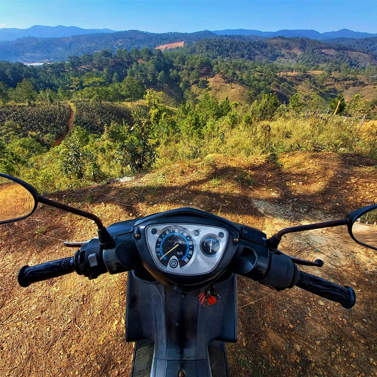
Many of Dalat’s most famous and impressive sights and attractions lie within a 10km-40km radius of the city centre. Linked by good roads through pretty scenery, these sights are best visited by motorbike. While Dalat city is increasing busy, noisy and polluted, the surrounding countryside is home to some of the most picturesque and easily accessible alpine scenery in Vietnam: pine-cloaked mountains, silver lakes and agricultural valleys all peppered with interesting places to stop and see, eat and drink. In this guide, I’ve created five short, easy, scenic, sight-packed motorbike routes and loops, all on paved roads and rideable in a half- or full-day depending on how much you stop and sightsee along the way. Aside from camping in the pine forests and exploring the city’s amazing cafe scene, riding through the countryside from sight to sight is the best way to experience Dalat, especially for first-time visitors.

[Back Top]
DALAT BY MOTORBIKE: 5 ROUTES & LOOPS
Exploring the Region’s Sights & Countryside on Two Wheels
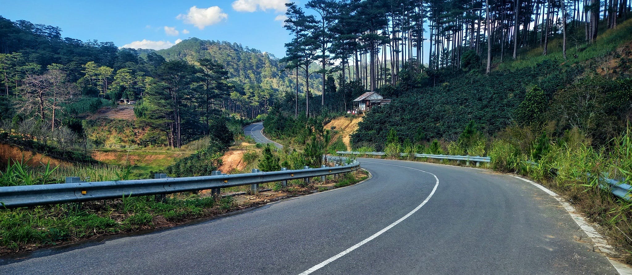
All five routes are plotted on my colour-coded map, but I’ve also created separate, more detailed maps for each route in the corresponding sections of this guide. I’ve written a brief overview of each of the five routes, including photos. The best months are the dry season (roughly November-April) when skies are likely to be clear, the air crisp and temperatures warm. At other times, there’s a high chance of persistent rain and mist, but these conditions have their charm in this region. All five routes are on paved roads (unless otherwise indicated on the maps or in the text) and can be ridden on any motorbike in a half- or full-day. Bike rental is possible through your accommodation or Dalat-based rental companies. Be careful in wet conditions when paved roads become slippery and dirt roads treacherous. For convenience, I’ve made the start/end point for all five routes the traffic circle at Hồ Xuân Hương Lake in Dalat city centre. These five routes are intended to take in some of Dalat’s main sights and scenic roads. There are many other roads to explore, but be warned that if using Google Maps to plan a different route, many roads turn out to be dirt. There is simply no way of being entirely up-to-date with road conditions. Things change all the time: no one (not even Google) knows what conditions are in real-time.

[Get the complete Offline Guide & Map Package for $15]
CONTENTS:
ROUTE 1: The Lake
ROUTE 2: The Mountain
ROUTE 3: The Tea Hill
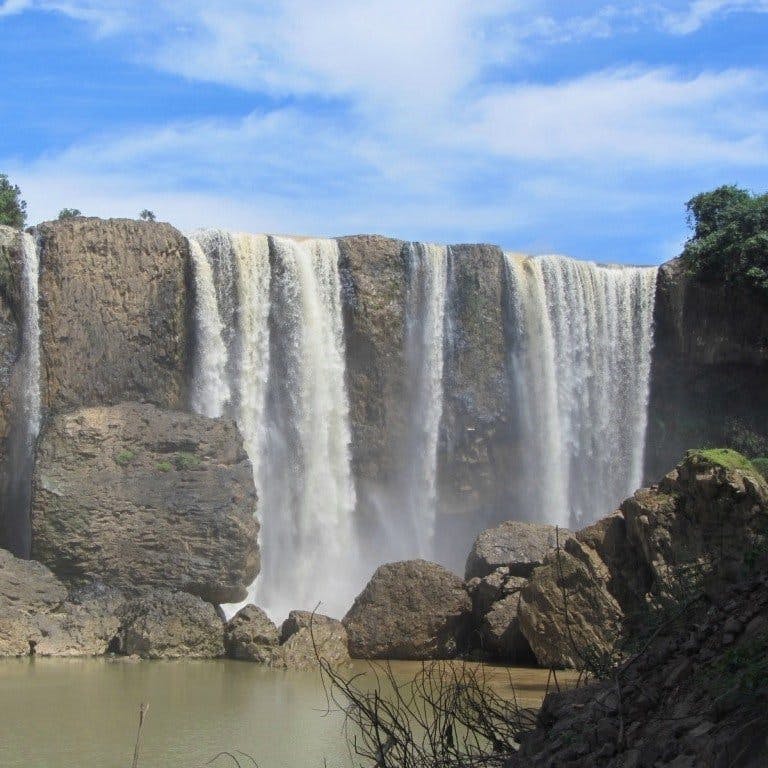
ROUTE 4: The Waterfall
ROUTE 5: The Pine Forest

Support My Work
Free | Independent | No Sponsored Content
“Hello, if you enjoy my website, please support it.
Thank you.” Tom
MAP:
Dalat by Motorbike: 5 Routes & Loops
[Get the complete Offline Guide & Map Package for $15]
Colour Key:
Route 1: The Lake
Route 2: The Mountain
Route 3: The Tea Hill
Route 4: The Waterfall
Route 5: The Pine Forest
*Road Safety & Disclaimer: Riding a motorbike in Vietnam – or anywhere in the world – has its dangers. I would hope & expect anyone who chooses to pursue a self-drive road trip based on the information on this website does so with care, respect & due diligence. I encourage careful riding & adherence to road rules, but I am not responsible for the legality or manner in which you ride, nor any negative consequences which may result from your decision to ride a motorbike in Vietnam: you do so at your own risk. Read more >

Route 1: The Lake
[Get the complete Offline Guide & Map Package for $15]
DETAILS:
- Route: around Tuyền Lâm Lake
- Distance: 45km (approx.)
- Duration: half-day/full-day
- Scenery: lakes, pine hills, forest
- Attractions: cafes, boating, pagodas, selfie-parks, clay tunnels
- Road Conditions: good, smooth, paved roads, light traffic
ROUTE 1 MAP: The Lake
View in a LARGER MAP
Description: A classic Dalat loop, ‘The Lake’ route skirts the edges of Hồ Tuyền Lâm, the region’s famous, glittering artificial lake, surrounded be gentle mountains and pine-studded hills. As well as the many scenic stretches of road with excellent, Swiss-like vistas, this route also passes some of Dalat’s major tourist attractions: The Crazy House, Bảo Đại Palace III, Đường Hầm Điêu Khắc (clay model tunnels), Trúc Lâm Pagoda and cable car, Happy Hill selfie-park, Prenn and Datanla waterfalls, and ‘Ghost Villa’ are all among the most-visited tourist sights in the region (see my route map.) In addition to these, the riding is easy and highly scenic, especially along the lakeside and the beautiful valley near the Wilder-nest Cafe and the Prenn Pass. Make sure to stop at some of the excellent cafes marked on my map, too. Personally, I prefer riding this loop anti-clockwise, but either direction is fine. All in all, a few hours spent on this loop is a memorable day out in Dalat. The lake is at its most magical at dawn and dusk (6am and 6pm). (Check my route map for places of interest, cafes and attractions.)
IMAGES | Route 1: The Lake


Route 2: The Mountain
[Get the complete Offline Guide & Map Package for $15]
DETAILS:
- Route: around Lang Biang mountain
- Distance: 55km (approx.)
- Duration: half-day/full-day
- Scenery: mountains, valleys, farms, greenhouses
- Attractions: trekking Lang Biang mountain, cafes, farms, museums, selfie-parks
- Road Conditions: good, smooth, paved roads, moderate traffic
ROUTE 2 MAP: The Mountain
View in a LARGER MAP
Description: Looping north of Dalat city, ‘The Mountain’ route skirts the lower slopes of Lang Biang, the highest peak in the region. Indeed, this route goes right up to the entrance for the trailhead for hiking up the mountain – a touristy excursion, but worth it for the views. Wherever you are on this loop, the green, distinctively pyramidal peak of Lang Biang can be seen poking into the clouds. The loop can be ridden in either direction (although I prefer to go anticlockwise), and includes a scenic detour north to Twin Beans Farm, a beautiful, secluded coffee plantation, cafe and accommodation. (The last section of this detour is still unpaved.) Just south of Twin Beans Farm, the route takes a relatively new and scenic road due west across to Lang Biang town (where the entrance to the mountain hike is). From here the route heads south into Dalat city, passing the famously kitsch Valley of Love (stop for a beer at the German House before or after) and the northern shores of the city’s iconic Xuân Hương Lake. In the east of the loop there are several clusters of excellent cafes and a couple of museums. (Check my route map for places of interest, cafes and more.)
IMAGES | Route 2: The Mountain


Route 3: The Tea Hill
[Get the complete Offline Guide & Map Package for $15]
DETAILS:
- Route: around Cầu Đất tea plantations
- Distance: 80km round-trip (approx.)
- Duration: half-day/full-day
- Scenery: tea hills, mountains, pine forests, wind farms
- Attractions: ‘cloud-hunting’ selfie-parks, cafes, pagodas, waterfalls
- Road Conditions: good, smooth, paved roads, moderate traffic
ROUTE 3 MAP: The Tea Hill
View in a LARGER MAP
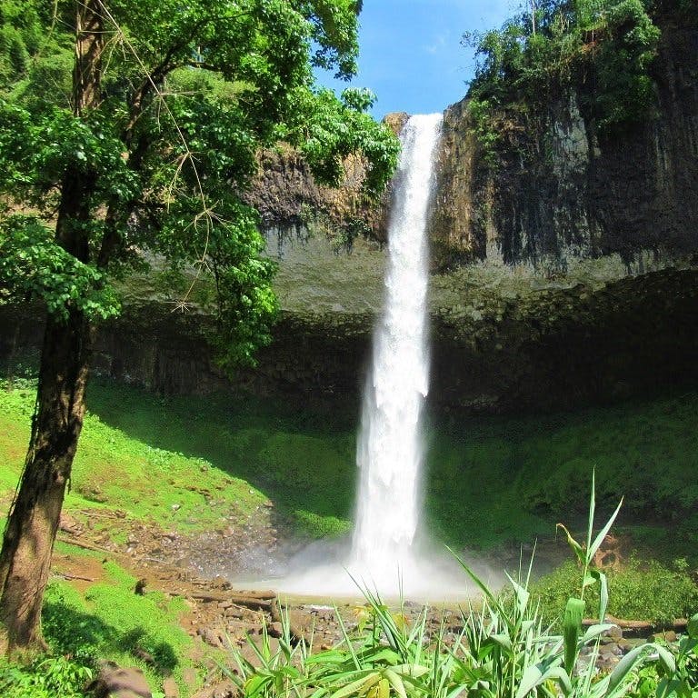
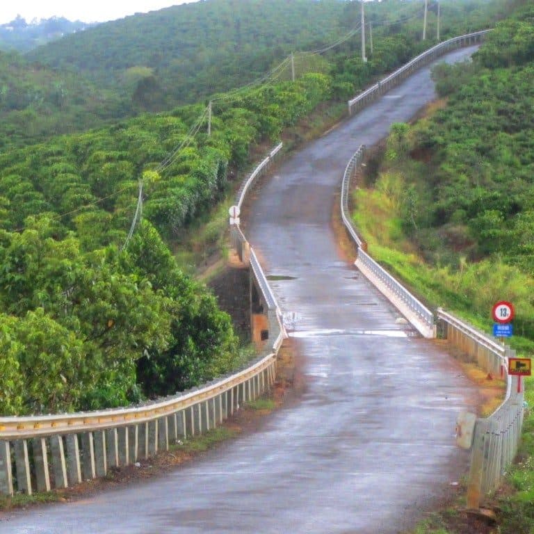
Description: Heading due east and then south of Dalat city centre, ‘The Tea Hill’ route passes through highland villages, farms, pagodas, waterfalls and tea plantations. On the way out of the city, the route passes by the old Dalat Train Station, which is appropriate because the rest of the route follows the old railway line for much of the way. In the busy little town of Trại Mát stop to look at the elaborate Linh Phước pagoda. Continuing east, take a brief detour to Tiger Waterfall (Thác Hang Cọp). From here the route goes south through farmland and pine trees, passing several selfie-parks, old railway tunnels and cafes perched on the sides of valleys, until entering the town of Cầu Đất. Famous for its coffee and tea hills, more recently Cầu Đất has become a centre for Vietnamese travellers to đi săn mây (‘go cloud hunting’). Indeed, there are several coffee shops (including the spectacular PhinDeli) and selfie-parks near the top of the cold, windswept tea hills (overlooked by towering wind turbines) that offer great views across the landscape, which waxes and wanes as the clouds and mist come and go. After exploring the tea hills, rejoin the main road for a scenic downhill stretch twisting through hairpins all the way to D’Ran village. Back in Dalat, stop by Cù Rú bar for a cocktail. (Check my map for sights and attractions along the route.)
*If you want to turn this route into a loop you can do so by taking QL27 due west of D’Ran and then north back to Dalat (see the red line on my map). However, this a rather boring, busy road, so I think it’s better to just return the way you came – on the blue line)
IMAGES | Route 3: The Tea Hill


Route 4: The Waterfall
[Get the complete Offline Guide & Map Package for $15]
DETAILS:
- Route: around Elephant Waterfall & beyond
- Distance: 120km round-trip (approx.)
- Duration: half-day/full-day
- Scenery: waterfalls, coffee farms, pine hills, valleys, villages
- Attractions: cafes, waterfalls, pagodas, selfie-parks,
- Road Conditions: good, smooth, paved roads, moderate traffic
ROUTE 4 MAP: The Waterfall
View in a LARGER MAP
Description: Spreading south and west of Dalat city, ‘The Waterfall’ route is a meandering ride on good roads through big landscapes, passing scenic valleys, waterfalls, selfie-parks, cafes and a couple of great detours. Head out of Dalat on DT725 due southwest down the Tà Nung Pass and into Nam Ban valley. Densely cultivated with fruits, flowers, vegetables and coffee, this valley is famous for the impressive cascade at Elephant Waterfall (Thác Voi) and several huge farms that have been turned into Instagram theme parks with creative props for posing in front of, such as Chuồn Chuồn, Dalaland and Mê Linh Coffee Garden. It’s pretty touristy, but just a bit of fun. In amongst the kitsch there are several more tasteful countryside cafes, such as Midori. Nam Ban and Tà Nung villages are quite busy and dusty, and traffic on the roads here is surprisingly heavy with farm trucks.
The second part of ‘The Waterfall’ route is due west of Dalat on a beautiful road through pine hills out to the seldom-visited villages of Đa Nghịt and Păng Tiêng. The road is wide, smooth and new, and the scenery very good. But just south of Păng Tiêng the road ends in dust and construction. At sometime in the not too distant future, this road will continue south all the way to Nam Ban, thus creating a big loop. But, at the time of research, the western half of the potential loop (the red line on my map) was still under construction and best avoided. Instead, take a couple short but very pretty one-way detours from Đa Nghịt on very steep paved lanes with excellent views (marked ‘Scenic detour 1 and 2’ on my map). Both detours currently dead-end but are worth the ride. Finally, don’t forget to stop for a whole roast chicken (gà nướng) and a bottle of local forest fruit rice wine (rượu sim) at the fantastic wooden shack restaurant of Thung Lũng Xanh. (See my route map for all places mentioned in this description and more.)
IMAGES | Route 4: The Waterfall


Route 5: The Pine Forest
[Get the complete Offline Guide & Map Package for $15]
DETAILS:
- Route: around Suối Vàng Lake & beyond
- Distance: 150km round-trip (approx.)
- Duration: full-day
- Scenery: lakes, pine forests, mountains, rivers
- Attractions: cafes, BBQs, river swimming, selfie-parks, the open road
- Road Conditions: good, smooth, paved roads, very light traffic
ROUTE 5 MAP: The Pine Forest
View in a LARGER MAP
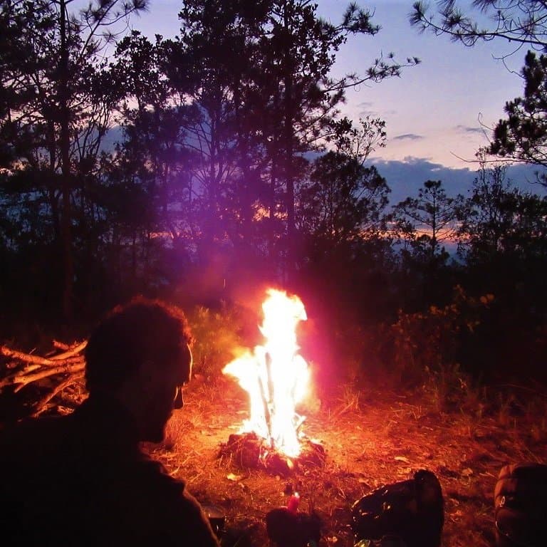
Description: Although the longest of the five routes, ‘The Pine Forest’ is also the easiest to navigate and ride. This is because most of the route is on one (fabulous) road leading north of Dalat deep into the pine forests, mountains and jungles. This route is light on traffic and big on scenery. Heading northwest of the city centre, the road rounds Suối Vàng Lake, along the shores of which several lakeside barbecue shacks sell grilled meats and cơm lam (sticky rice cooked in a length of bamboo). The vistas are pretty and the riding is easy. However, it’s north of the lake that this route really starts to shine. After passing the countryside theme park at Làng Cù Lần, the road ploughs through dense pine forests which cloak the purple ridges for as far as the eye can see. The air is cool and clear, the scent of pine is on the breeze and the whispering of their needles is the only sound to be heard in the vast landscape. In fact, this is part of the Trường Sơn Đông Road, which leads all the way north to central Vietnam. However, this particular section hasn’t been finished yet, and dead-ends after passing along a beautiful river some 70km north of Dalat. Even though this is a (long) one-way ride, it’s well worth it because the views are amazing, the river is swimmable, the riding easy and joyous, and there is no one else on the road. Just make sure you have enough gas, because the only petrol available is at the village of Đưng K’Nớ. (See my route map for places mentioned in this description and more.)
IMAGES | Route 5: The Pine Forest


*Disclosure: I never receive payment for anything I write: my content is always free and independent. I’ve written this guide because I want to: I like these routes and I want my readers to know about them. For more details, see my Disclosure & Disclaimer statements and my About Page


Hi Tom, we have just visited Dalat, the first time since 2018, and did parts of your suggested rides. A few updates/comments:
The Lakes Loop: 1) the road to Zen Lakeside Cafe is restricted access, and the gates were chained shut. Indeed, the villas there looked as if they have been empty for a while. 2) Google maps shows Wider-nest Cafe as being in the middle of the golf course, not accessible to non-golfers or people staying at the resort. We couldn’t see any signs or track off the main road. 3) the loud disco music put us off going into the Prenn Waterfall, which looks like a theme park with fake cliffs and golf buggies driving around.
Waterfalls Loop: the viewing platforms at Elephant Falls are closed ‘for maintenance’. However, it can
be seen from the temple next door: the steps to the left of the huge Quan Am (Guan Yin) statue lead you down to an attractive viewpoint (lots of multi-coloured bougainvillea).
We like the café at Midori farm and homestay, very pleasant, nice view
Hi Jonathan,
Thanks for your trip report. Glad you enjoyed some of the routes. Indeed, things change quickly in and around Đà Lạt. The routes and roads should still be good, even if the specific cafes, places to see, etc. come and go.
Best,
Tom
Yes, there has been, naturally, quite a few changes since we were last in Dalat, although mainly on the outskirts – the central part of town is pretty much the same.
One part to avoid staying is anywhere along Huỳnh Tấn Phát unless you like looking at valleys and hillsides totally covered in plastic greenhouses.
We stayed at Mimoza Homestay, about 13km from the town centre, close to the wind turbines on your Tea Hills route. Nice wooden cabins overlooking a quiet valley. Just a note that it is north facing, which means cool in winter, especially when a cold northerly is blowing a hoodie, as it was on our first day.
Not far away is Berry Farm, around 300m off the main road heading back towards Dalat, on a track through the pine forest. Well worth the detour for a drink, ice cream; a tranquil spot, with a lovely view.
Hi Jonathan,
Yes, lots of good accommodation options in and around Da Lat now. I know what you mean about the plastic green houses, but it’s also worth noting that the valleys full of green houses that are lit up by lightbulbs at night have become an attraction for many domestic travellers – cafes and hotels are actually set up to get a good view of the green houses.
Best,
Tom
Route 2
The road to Twin Beans Farm is sealed except for the last 250 metres
Hi Seamus,
Thanks for the update. Great to hear that route is now fully paved – it’s a fun little side route.
Best,
Tom
We hebben de route 4 gedaan de weg was nog in aanbouw en was zwaar maar ook indrukwekkend. Wij zouden dit achteraf niet nog eens gedaan hebben. Toch was dit een onvergetelijke ervaring en bedankt voor het delen van de route.
Hi Max,
Thank you for your trip report. I’m glad you enjoyed the route – I hope they will finish that road soon.
Best,
Tom
Hi Tom, we would like to ride one of your five routes. Here below we see Elie saying how easy it was to import the route to Google maps. Unfortunately we have no idea how, can you please explain? Thanks in advance, Karel
Hi Karel,
You should be able to open any of my google maps on your phone and then select the option to ‘Download KML’, then you should be able to open the map in the Google Maps app on your phone. The process is sometimes different depending on your device and OS. Please try googling something like ‘how to download KML google maps on [device/OS name]’.
I hope this helps,
Tom
Just wanted to say that I just spent a few days in Jan 2023 in Da Lat, and it ended up being the highlight of my Viet Nam trip thanks to this guide! Also, I REALLY appreciate how easy it is to import to Google Maps.
I did all five routes and found them to be very helpful and up-to-date. The roads were extremely fun to drive and i didn’t see many other foreign tourists so it definitely felt like an authentic experience. I also took my time and stopped at random coffee shops etc.
Thanks for putting this guide together, Tom!
Hi Elie,
Thank you for your kind words and it’s great to hear that you enjoyed riding around Dalat on these routes. We must have overlapped in Dalat for a day or two – I just returned from there a few days ago 🙂
Thanks again,
Tom