
Last updated December 2017 | Words and photos by Vietnam Coracle | 221 comments
This post was last updated 7 years ago. Please check the comments section for possible updates, or read more on my Updates & Accuracy page.
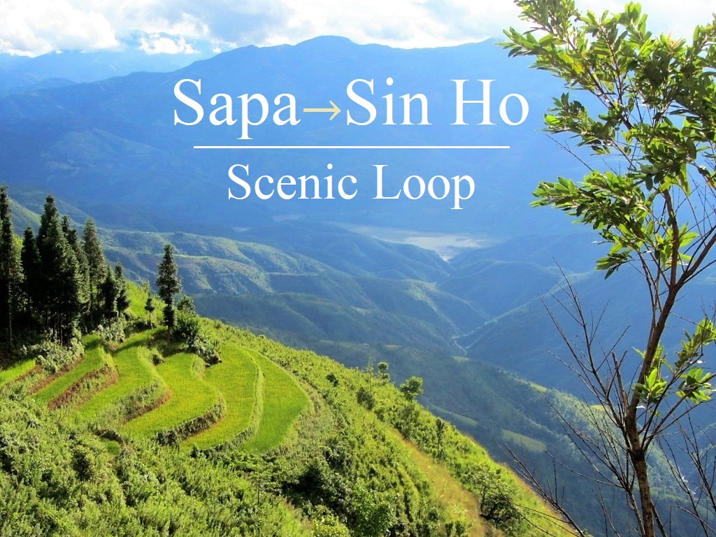
INTRODUCTION | GUIDE | MAP | RELATED POSTS
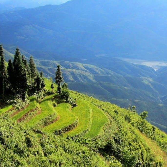
Sapa and Sin Ho are two towns high up on the slopes of the Hoàng Liên Sơn Mountain Range, known in French colonial times as the Tonkinese Alps. Sapa is a famous mountain retreat, enormously popular with Vietnamese and foreign tourists. Sin Ho, on the other hand, is hardly ever visited by travellers. These two highland towns are connected by lofty mountain passes, affording spectacular views over a landscape on a scale not found anywhere else in Vietnam. Rent a motorbike from Sapa and spend a couple of days on the Sapa-Sin Ho Scenic Loop; you’ll be rewarded with some of the grandest alpine scenery in Southeast Asia.
Majestic: the Sapa-Sin Ho Loop takes you through some of the grandest landscape in Southeast Asia
[Back Top]
GUIDE: SAPA-SIN HO SCENIC LOOP
ROAD TRIP DETAILS:
- Total Distance: 320km
- Duration: 2-4 days
- Route: a round-trip between Sapa & Sin Ho on mountain passes [MAP]
- Road Conditions: good mountain highways & back-roads, some rough patches
- Scenery: the Tonkinese Alps: valleys, mountains & rivers on the roof of Indochina
ROAD TRIP CONTENTS:
- SECTION 1: Sapa to Lai Chau (via road QL4D): 70km
- SECTION 2: Lai Chau to Sin Ho (via Phong Tho): 115km
- SECTION 3: Sin Ho to Sapa (via road 4D cũ): 135km
ABOUT THIS ROUTE:
I’ve written this guide in 3 sections, going anti-clockwise on the loop, but you can drive it in either direction. The total distance is 320km, but I’ve also included an optional side loop which would add another 80km to the total distance. Note that each section doesn’t necessarily correspond to one day on the road. You could ride the entire loop in 2 days. However, the roads are steep and windy so progress is slower than in the lowlands, and the scenery is superb so you’ll want to stop regularly to admire the views. 3-4 days is perfect. Weather and time of year are important considerations on this loop. Landslides are a common occurrence after wet weather and can block roads for hours or even days. Unfortunately, weather is very hard to predict in this area and conditions can change very suddenly all year round. The good news is that most of the roads on this loop are now either in excellent condition or in the process of being upgraded. April-May and September-October are the best months to go: the weather is warm(-er) and the terraced rice fields are a good colour. Below is my full guide to the Sapa-Sin Ho Loop, including a description of the route, suggestions of places to stay, eat and see, and my annotated map.

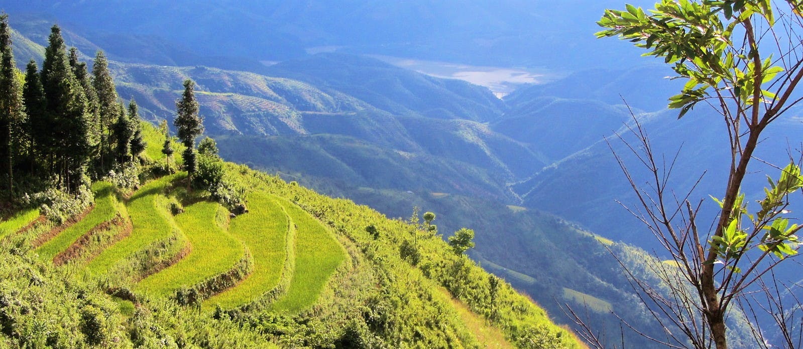
Threading through the mountains between Sapa & Sin Ho in Vietnam’s stunning northwest region
ROUTE MAP:
Sapa-Sin Ho Scenic Loop | 320km
View in a LARGER MAP
[Back Top]
SECTION 1:
Route: Sapa to Lai Chau (via road QL4D) | Distance: 70km [MAP]
Head west on Road QL4D from the mist-shrouded town of Sapa. The first few kilometres getting out of Sapa can be pretty grim these days, because of potholed, mud-streaked, traffic-clogged, and construction-choked roads. Eventually, however, the road clears and passes a couple of pretty waterfalls (Silver Falls [Thác Bạc] & Love Falls [Thác Tình Yêu]) before reaching the top of the Tram Ton Pass (also known as O Quy Ho or Heaven’s Gate), Vietnam’s highest mountain road at 1,900m (6,230ft). You’ll know when you get here because, if the weather is clear, you’ll see the pass snaking around the mountains below you. Even in misty conditions you’ll know you’ve arrived because it’s significantly warmer on the pass than in Sapa: the pass is both a climatic divide and a provincial one, marking the border of Lao Cai and Lai Chau provinces. There are a few makeshift, rickety-looking viewing platforms by the roadside offering stupendous vistas.

The spectacular Tram Ton Pass is the highest road in Vietnam: it’s a wonderful ride
The impressive, crenelated ridge to the south is Mount Fansipan, Indochina’s highest peak at 3,143m (10,312ft). Its looming presence bears down on the pass, casting a cold shadow over the road. Deep down in the valley indigo rivers forge paths over large boulders. Fansipan is so big that it dominates the scenery all the way to Lai Chau.

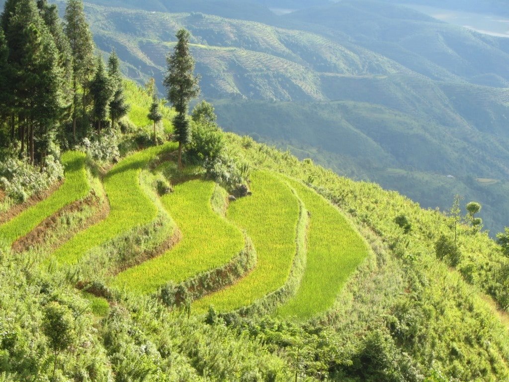
The Tram Ton Pass winds down through more pristine alpine scenery and past the Dong Tien Son caves to Tam Duong town. It’s not much of a town – although its new multi-lane high-street would suggest otherwise – but if you need a rest there are a couple of good accommodation options and food stalls along the main road. Putaleng Hotel has excellent rooms for about $20, or cheaper digs can be found at Tan Sinh Guest House. Continue northwest on Road QL4D for 40km to Lai Chau (perhaps detouring to take a quick look at the impressive Tac Tinh Falls, just behind Tam Duong town). If you’re visiting during September or October look out for some absurdly pretty valleys of terraced rice fields about 10km before descending into Lai Chau. This is the kind of scenery that brochures promise Sapa will offer, but in reality you have to travel a little further afield to find sights like this….

Scenes like this await you on the road to Lai Chau if you visit in late summer to early autumn
Lai Chau city is a brand new concrete creation in a remote valley surrounded by pyramidal peaks. It consists largely of grandiose government buildings, wide empty boulevards and depressingly vacant public spaces. On a wet, cold day Lai Chau is a painfully soulless place to be, but on a bright day it can be quite appealing. The scale of infrastructure and architecture are not in proportion to the population or significance of the city, but over the last couple of years local life has started to inject some character to this somber provincial capital. Thus, Lai Chau makes a convenient overnight stop. There are decent-value guest houses (‘nhà nghỉ‘ in Vietnamese) and hotels on the main road (30 Tháng 4 Street). Try Binh Long Hotel (2 Tháng 8 Street | tel: 0213 2488 488) or Hà Nhi Hotel (30 Tháng 4 Street | tel: 0213 6250 999) for cheap, clean rooms. Or you could ‘splash out’ ($30) on the Muong Thanh Lai Chau Hotel, which has balconies with views over the town and tea plantations as well as a (often dirty) pool. The area around the lake has some good bánh xèo (Vietnamese savoury pancakes) and ốc (snails and shells) joints in the late afternoon/evening. Or meat lovers should try the roast suckling pig (lợn quay) at Quán 25 (62, 30 Tháng 4 Street). For good coffee head to Gateway Cafe (305 Tran Hung Dao Street).
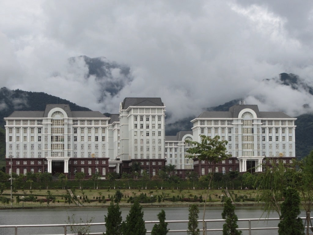
Lai Chau is a fairly soulless town, especially in bad weather, but it’ll do for a night
SECTION 2:
Route: Lai Chau to Sin Ho (via Phong Tho) | Distance: 115km [MAP]
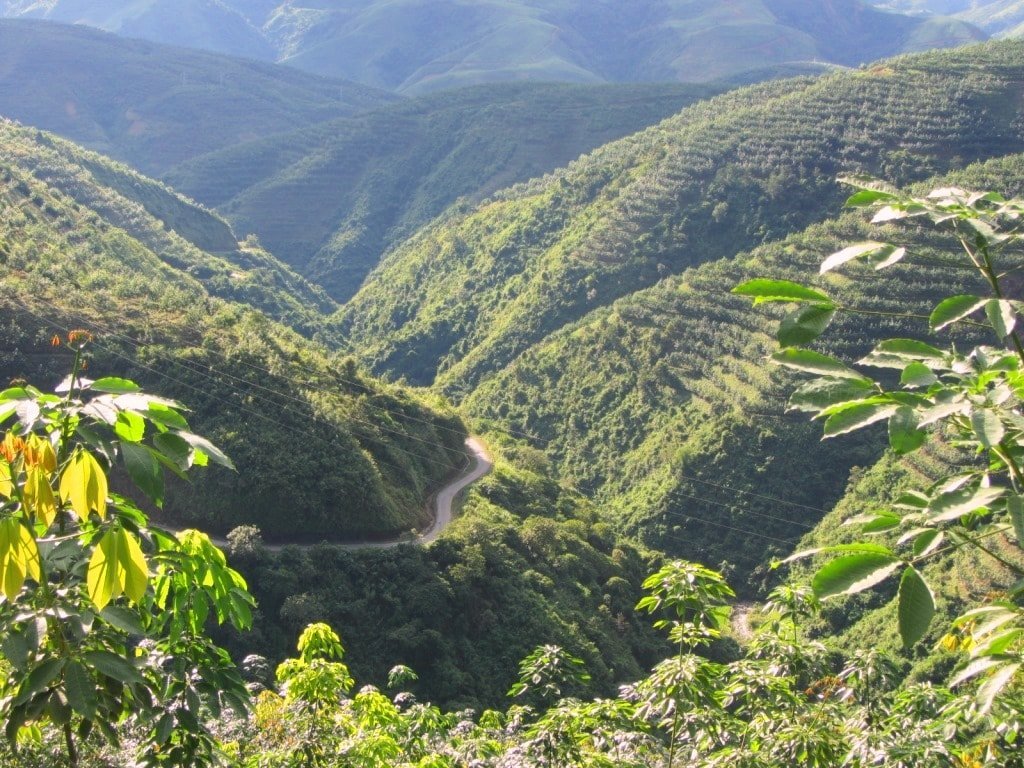
From Lai Chau continue northwest on Road QL4D toward the town of Phong Tho. This section of road is in very good condition and passes over high mountains before dropping down into a valley. Eight kilometres before reaching Phong Tho, there’s a turning due north for Muong So. This is the beginning of an optional and scenic side loop. The total distance of this detour is around 70-80km. The scenery is very mountainous, heavily farmed with terraces of rice and corn, and dotted with minority hamlets. There are a couple of local guest houses in Muong So, including the clean, simple and friendly Gia Bao (0976 677 999). Alternatively, continue on QL4D to Phong Tho, where there are more hotels and plenty of local rice eateries. By far the most atmospheric of the places to stay in Phong Tho is the Lan Anh Hotel (0989 673 888), a timber, tile and concrete structure built around a verdant courtyard. After Phong Tho the road turns back on itself, becoming QL12 and heading southwest along the Nam Na River valley. The road is in good condition, and it’s a quiet, easy stretch of riding through a pleasant valley all the way to the Nam Cay/Chan Nua junction.

Road QL12 from Phong Tho is a pleasant, riverside ride on a good, quiet highway
Nam Cay/Chan Nua is less of a town and more of a country junction. There’s a guest house (nhà nghỉ) here called Hưng Tâm (Tel: 0948 943 643) if you feel like staying the night, and some local food is also available. At the junction turn left (due east) on Road TL128 for the impossibly scenic and steep ride to Sin Ho. In good weather this route is exceptional. Cutting a path in the mountainside, the single-lane road zig-zags up for 40km to the isolated mountaintop town of Sin Ho. The views over ridges, farmland, ethnic minority villages and clear rivers are superb. Every time I ride up here I have a grin on my face the whole way, constantly stopping and gazing in disbelief at the landscape. The road conditions are pretty good for most of the climb, but landslides are a regular occurrence, so expect some extended patches of earth, mud and potholes. If it’s been raining a lot, it may become quite slippery.
Jaw-dropping: the scenery on the road to Sin Ho is simply staggering
Just when you think it can’t possibly get any better, the road snakes through a series of switchbacks until it bears northwards, thus opening up astonishing views down to the Nam Na river valley and far beyond to the distant mountain ranges straddling the border with China. It’s a breathtaking ride.

Tiny hamlets cling to mountainsides outside Sin Ho, blue ridges disappearing into the distance
Like Sapa, Sin Ho is often engulfed in mist and drizzling rain. The town is a bit scruffy and feels very remote. But, as with every town and city in Vietnam, upgrades to public spaces are beginning to make Sin Ho feel more welcoming with each year. Built on a small plateau, at an altitude of over 1,000m (3,300ft), Sin Ho is very cool, especially in the evenings. Ringed by limestone pinnacles and surrounded by minority villages scattered over the mountainside, this town has huge tourist potential, but as yet very few travellers make the trip.

Sin Ho is subject to very changeable weather, making the landscape mysterious and brooding
Try to time your visit to catch the Sunday market. Busiest between 8am-11am, Sin Ho market receives hundreds of minority women dressed in their various colourful clothing. They make the journey by foot (sometimes starting before dawn) in order to buy (not sell) supplies for the week ahead. Unlike Sapa market and the horrendously touristy Bac Ha Market, where minority people are more likely to be seen selling to foreign and Vietnamese tourists, Sin Ho market is the real deal. This means there’s no hassling to buy trinkets and garments: most of what’s for sale is fresh meat, vegetables, fruit and practical equipment for use in the villages. Sin Ho market is noticeably calm and unhurried compared to other, more famous, minority markets in the region.

A girl from one of Vietnam’s many ethnic minorities shops at Sin Ho’s Sunday market
Sin Ho has a smattering of local cơm phở (rice and noodles) joints, particularly around the main square, and there’s a new bakery opened, called Thanh Nam. The town has an increasing number of budget places to stay, mostly in the form of nhà nghỉ (guest houses). However, by far my favourite place to stay is the Phuc Tho Hotel (0213 3870 186). Just a 30 second walk from the market, this is a relatively large hotel run by a sweet older couple. Rooms have balconies looking over town and the main square. Rooms are basic but clean, including hot water showers: 200,000-600,000vnđ for 2-6 people sharing. If, for some reason, you don’t like the Phuc Tho Hotel, there are several other decent accommodation options, including the Hong Hoa Guest House (o1687 271 123) and the Thai Binh Hotel (02313 870 366). But perhaps the most interesting (and certainly the cheapest) option is Ba Sanh Homestay (01649 434 628). On the southern edge of town, Ba Sanh offers dirt-cheap digs (a couple of dollars) sleeping in a communal room, but the real attraction is the Dao minority-style hot herbal baths. Costing just a few dollars (for staying or outside guests) these medicinal baths might be just what you need after a long, wet, cold day riding the mountain passes.

Town in the clouds: Sin Ho sits on a plateau surrounded by high peaks
SECTION 3:
Route: Sin Ho to Sapa (via road 4D cũ) | Distance: 135km [MAP]
The 60km descent on Road TL128 from Sin Ho back down to Lai Chau is just as beautiful as the ride up. As the road emerges from the mist, which on most days engulfs the town of Sin Ho, a vast landscape opens up beneath you: endless mountains stretching into the distance and craterous valleys dotted with stilt-home villages clustered around clear streams. However, there are some short but treacherous sections for the first 10km out of Sin Ho, where maintenance work is ongoing and landslides cause the surface to be muddy and slick. Take your time and take care on this section, especially in wet or damp conditions.
About a third of the way down to Lai Chau, there’s a junction with a turn off to the right (due south) to Nam Tam. Although this looks like an appealing road to take, I was told that road conditions were bad. (If you want to go to Nam Tam, approach from the north via Lai Chau instead, as this road is good and scenic.). As road DT128 drops further, through very dense jungle, with the city of Lai Chau visible in the valley, take a short break from riding in order to visit the caves of Pu Sam Cap.

More wonderful and expansive views on the pass down from Sin Ho to Lai Chau
Back in Lai Chau take the alternative route (road 4D cũ) to Tam Duong. To get there turn right (due southeast) at the Ha Nhi Hotel on Dang Van Ngu Street. This is a pretty, quiet route through limestone karsts and extensive tea plantations. It’s almost exactly the same length as taking the main road (QL4D). From Tam Duong, rejoin QL4D and retrace your route back to Sapa via the Tram Ton Pass.

Road 4D cũ (the alternative route from Lai Chau to Tam Duong) is a lush, quiet route through farmland
RELATED POSTS:
[Back Top]
Did the loop from Sapa to Lai Chau and then the extra 80km and back cause we didnt have enought time. We were looking for an alternative to Ha Giang and It was just perfect. We only saw few locals on the road, no tourists at all and the views were amazing!!!! We even stopped in a random hamlet to rest a little and the locals invited us to drink and eat…amazing. The road was on perfect condition except the 3 last km that were bumpy due to landslides we suppose…. But totally recommended!!!! Just FYI we did the route with Honda Wave S so any 100cc bike would work.
Hi Diego,
Thank you for your trip report and road updates – it’s very useful to me and other riders. I’m really happy to hear you enjoy this route and got to experience a beautiful part of Vietnam away from the crowds. And yes, I agree, any motorbike can do this loop if it’s in good condition and the roads are clear.
Best,
Tom
Great loop, thanks for sharing it!
As of writing this comment there are a lot of road works on the DT128 toad the southern part of it.
Hi Val,
Thanks for the update on road conditions. Hopefully, the roadworks will only last a few months.
Best,
Tom
A highly recommended hotel in Sin Ho is the Khach San Hong Ho. 300,000 VND for a spacious room with a new bathroom.
Hi Frank,
Thanks for the recommendation.
Best,
Tom
Hello,
We are currently in Sapa and reconsidering whether to do this loop or not. We came from Dien Bien Phu and we saw a lot of smoke due to burning season which seriously impedes visibility. Did any of the previous posters do this loop in March? How was the experience for you?
Cheers,
Flo
Hi Flo,
Personally, I would do this route if the weather is good – it’s worth it.
Best,
Tom
Hello Tom,
Thanks for the advice. We went for it and were not disappointed. We spent 4 days on the loop. First night, we stayed in Lai Châu, Pa Tan (Thao Trang hotel, cool little hotel overlooking the river) and Sin Hô in Bùi Sang Homestay where they offer herbal baths and dinner. We felt very welcome there.
We didn’t feel the smoke was too much of an issue although it definitely limited the visibility. We had wonderful weather for 3 days so we really can’t complain.
Roads are in very good state generally.
Two sections are bad at the moment, where you need to be careful.
– the road between Dao San and Nam Cay in the optional loop. Lots of potholes, some small sections with pointy rocks, reduced visibility due to vegetation and sharp turns.
– the second half of the way up to Sin Hô. Lots of construction works at the moment, so expect sand, gravel and potholes.
My favorite parts were the optional loop, the way up to Sin Ho and the part between Lai Châu and the intersection (great road, great views).
So glad we went for it instead of the Hà Giang loop! We were the only tourists the whole way through.
Thanks!
Hi Flo,
Thank you for your trip report and updates on road conditions – it’s great that you enjoyed this route and your updates are very helpful to me and to other travellers.
Best,
Tom
Hi all,
On the loop now, had to find accommodation (Nhà nghỉ Quân Chớn -250k per night) after sin ho to the south as a thunderstorm rolled through.
Road DT128 out of sin ho (traveling clockwise) to QL12 is in a bad state for the most part but the views are still amazing. Timing this ride for an evening created heavenly scenes of god rays glistening through the brooding clouds into the valleys below. This along with the bridge over nam nah river looked like something out of Harry Potter.
If driving with a partner I suggest allowing extra time for photos and bum rests! As for Sin ho my partner and I felt like we had gone to the wrong town in relation to the descriptions above. After crusing around the town we stopped for maybe half an hour at the stagnant “lake” to have a beer and snacks. Found that the stay in Lai chau (Khách Sạn Minh Sơn Lai Châu-250k one night) with a view over the many mountain peaks to be more pleasant.
Thinking of extending our trip to a 4 day by either heading south and going along dt127 which follows the river and loops back north. Or head north and fit the loop on the border to China (if we don’t get turned back).
After ending in Sapa we plan to head east to ha giang to do the loop, but concerned as to how busy it might be.
PS the beds at both the nha nghi’s listed have felt like sleeping on floors.
Hi Ross,
Thank you for the road updates. Glad you’re enjoying the ride. Good to know the scenery is still good, even though parts of the road aren’t in good condition at the moment.
Sorry you didn’t like Sin Ho, most people find it quite interesting and in a great location high up in the mountains.
Haha! I love hard beds – they’re great for sleep and much better for your body 🙂
Best,
Tom
Hello Tom,
Just back in Sapa after 4 days of amazing Loop. Thanks for your post!
To update the roads status, all roads are perfect!
We modified a bit the loop with your intel and I would like to share it with all the people here if someone is thinking to do something similar.
In the second section, we wanted to drive as close to China as posible, so we went from Lai Chau to Dao San making the detour you suggest in the post. The roads here were pefect, clean asphalt all the way to Dao San.
Here, instead of going direction Ta Phin, we keept driving north (with perfect clean asphalt) following the road DT132 (trough Den thang A, Ho meo, Pa Vay Su, Si Choang) until Si Choang.
In Si Choang, in the petrol station, instead of following the DT132 that seems to enter China at some point, we turn left in a road called “Tuan Bien” that leads you until the border with China in “JinshuiHezen”. The road is semi asphalt semi offroad road. It’s not complicated if you drive slowly. We have no offroad experience and we did it with no problems. It’s a 33km road that follows the river that separates Vietnam and China. You drive parallel to a wall China has built to block vietnamese people to enter China. For us, a really cool experience.
In the section three, although you mentioned that someone told you the road was not good when you did it, we decided to drive from Sin Ho to Lai Chau via Nam Trang. Nowadays, the road is perfect, clean asphalt and the landscape is amazing! Rice fields, small villages, pagodas,… really amazing.
That’s all 😊
Thanks!
Hi,
Thanks for the trip report. The ‘tuan bien’ road is a border zone, so technically foreign travellers aren’t allowed to ride without a permit. Hopefully, the rules will be relaxed a bit in the future.
Best,
Tom
Hello!
I just finish to ride the loop clockwise. The road south of Sin Ho (the road DT128 until the junction with the QL12) is in bad condition at the moment. There were many landslides, but it was still possible to pass. All this area is full of holes, dirty patch, and rocks. I doubt that there was a full km that was fully pave, it has been in the past, but it’s not anymore… The driving was fine as it was a sunny day, I had to drive very slowly, but I would not recommend if it’s wet or foggy, especially if you drive it in that direction as you will go down from the mountain.
I stayed at Nhà Nghi Duyên Hai in Sin Ho, I paid 150k, and it was clean and alright for a night.
The Coffee Hoàng Gia and the restaurant Jumong Quàn are really good options for coffee and food!
Enjoy the loop, the sceneries are stunning!
Hi Marie-France,
Thank you for the trip report and useful road updates. And I’m glad you enjoyed the scenery on this loop.
Best,
Tom
Thank you for the information. I plan to ride from Muong Lay to Sin Ho via the DT128, and then from Sin Ho on to Sapa. I am on a Honda 110 Wave. I am wondering what kind of bike you were on and how you think a semi automatic would handle the conditions you describe? Thank you for any feedback you or Tom may have.
Hi Mark,
In dry conditions, you should be fine riding on a Honda 110 on that route (I’ve ridden all the routes on my website on a Yamaha automatic). If it is very wet, then landslides are possible and parts of the road may be muddy and difficult. Just go by the weather conditions when you are there: worst case scenario is that you ride up as far as you can and then either have to way for the road to be cleared or go back down to the main road.
Best,
Tom
Hi Tom,
We’d like to thank you very much for this awesome tour you created.
We completed it in three days and it made us experience the “real” Vietnam. 🇻🇳
✨Best highlight: we felt like the only travellers on those roads with locals waving hello to us while we were riding!
🏍️ We rented a 135cc automatic Yamaha at Thuê xe máy uy tín giá rẻ Sapa, very fair price compared to others. The motorbike did the job well, up and down mountains and hills. If you know how to drive a motorbike, you will be fine.
🛣️ Roads were mostly in good condition apart from the way up to Sin Ho which was a bit bumpy – nothing to worry about, you just need to be a bit more careful.
🏩 Accommodations were easy to find, you can also book them on the spot or find a homestay. Villa De La Roseraie in Sin Ho told us one night would be 800K, so we decided instead to stay at the the Nhà nghỉ Duyên Hải, not fancy at all but way cheaper (around 150k dong).
🍽️ Must try in Lai Chau is the bahn xeo from Bánh Xèo Kim Ngân, highly recommended!
As for Sin Ho, try the fried tofu and the veggie noodles at Jumong Quán – Ẩm Thực Tây Bắc: big portions and tasty food.
Enjoy the ride and thank you again Tom! 😊
Albi & Bea
Hi Alberto & Beatrice,
Thanks for your trip report and updates. I’m very happy to hear you enjoyed your road trip.
Best,
Tom
The name of the bakery I mentioned is Hoang Gia Bakery. They are not listed on Google Maps.
Update:
Wanted to try the hot herbal bath based on your recommendation. Ba Sanh Homestay seems to be closed as the garden gate was locked. Pity though as I’ve never tried the herbal bath.
Thanh Nam bakery did not have any cake or buns. But there was another bakery which I forgot the name about 15 meters away. If you are coming from Phuc To Hotel, Thanh Nam will be on your right hand side. This bakery will be on the left hand side and is before Thanh Nam.
Last night I tried the roast pork you mentioned and it was nice but pricey in my opinion. A small plate of roast pork with rice and a coke cost 130k. Luckily I did not order anything else as it was very filling. The roast pork made up for the lousy lunch I had. LOL.
This morning 5/6 left Lai Chau at 0630 for Phong Tho via QL4D/QL100/DT132/QL12.
Decided to press on to Sin Ho taking the longer route QL12/DT128.
Staying at Khach San Phuc Tho for 200k per night. A bit haggard and old but it will do. The elderly couple were very happy to get a guest and I did not bother to go elsewhere to check out the room.
Road conditions are all right but I got caught in the rain for an hour.
Left Lao Cai this morning 4/6 to Lai Chau. I took part of the Y Ty road and it was quite scenic. Originally planned to stay overnight at Y Ty and do the whole loop but due to the issues of foreigners not allowed to stay without a permit I decided to do part of the loop.
It was a pleasant ride and am now at Lai Chau for the night.
Lai Chau is exactly like you described big buildings but seems soulless. Lol.
Staying at the Binh Long Hotel 2 for 300k. The hotel looks fancy.
When riding around the area looking for food o saw the Binh Long Hotel 1 nearby which doesn’t look as new as V2.
Due to the intense humidity I try to leave the hotel by 0630 and arrive my next destination before 1200.
Hi Brendon,
Good to hear you’re enjoying the ride. Yes, it’s a pity foreigners can’t just turn up and stay overnight in Y Ty, but at least there are other options for an overnight stay in the region. Lai Chau makes a lot of sense.
Best,
Tom
Hi Tom!
Amazing post! We used you Ha Ging Loop post a couple of years ago and it was also amazing!
I would like to ask if you know any detour or sport to see the border with China as in the “North pole” in Ha Giang. I loved it that time and I would like to feel close to China also this time.
There are a couple of detours from Nam Cay (using QL12) or An Tan using sideroads. Any suggestion?
Thanks!!
Hi,
Yes, you could follow those routes to the Chinese border. However, ever since the pandemic, border areas have become much more ‘sensitive’ and patrolled by border police: it’s quite common for foreign riders to be stopped and turned back, especially near remote borders. So bear that in mind if you do decide to take a detour to a border.
Best,
Tom
Good point! Thanks!
We may try to do it from Khoa San to Nam Cay. I will post and update in October!
Thanks
I will be doing this loop soon. Sin Sui Ho would be an easy side trip. Do you recommend it?
tia
Hi Mark,
Yes, that’s a good idea.
Best,
Tom
We have just finished this scenic trip with a 3 days tour. We have done the small extra loop taking the road QL100 between Muong so and Nam Cay.
Thank you for the suggestion ! The road was very scenic and varied, passing through rice fields, tea plantations and small villages !
We absolutely loved it !
All the road where in good conditions except the Road 4D cũ from Lai Chau. This valley is very pretty and worth a trip, however there is currently massive road works with big engines and slippery roads.
The road to sin ho is absolutely sublime !
Hi Marion,
Thanks for your trip report. I’m glad you enjoyed it. And it’s great to know that most of the roads are in good condition – I hope the works on 4D cũ will be finished soon.
Best,
Tom
Hi!
We did this loop at the beginning of May 2023 and it was amazing! Beautiful scenery, interesting villages and perfect roads almost all the way through.
I will go through some practical information and personal experience.
We rented a motorbike (automatic, not sure how many cc’s) from our hotel in Sapa for 140k/day. This was on the higher side but we didn’t want to risk renting it at some random place. Not sure if this is normal, but they wanted a passport as a deposit. We agreed, but after we left we found it a bit stupid of ourselves. For most hotels around the loop you need to show your passport and visa stamp at check-in and we were warned that you can get fined by the police if they find out that you don’t have it (next to that, its just not very nice to travel without a passport). We had no problems and the copy of my passport and evisa were enough for the hotels, but I still do not recommend it. We had only one encounter with the police which was in Sapa (I think they were doing alcohol checks), but as soon as they saw we were tourists, they let us through.
On our last day in Sapa we stayed at Cloud House Sapa at the north-east side of Sapa (highly recommend, super nice hostess, breakfast and room) where they had good looking motorcycles for only 110k/day.
My partner drove the whole thing and his only experience was a few days in the mountains of Myanmar. If you drive carefully and not too fast it should be fine. There wasn’t a lot of traffic except for Sapa. Some locals can drive like crazy everywhere though, so you still have to be very attentive while driving. But in general the locals were pretty carefull as well. The roads were perfect except for the DT128, south of Sin Ho. It was doable, but quite bumpy and a lot of holes. I have to note that during our trip it was completely sunny, no rain or fog. Only for the last 30 km we had fog, which made it more difficult, a bit slippery and slower.
We did the trip in 3 days, with a detour which made it a little under 4 days. We only encountered other tourists on the first 30 km to Lai Chau. On day one we went from Sapa to Lai Chau with a stop at the Tac Tinh Waterfall. This was a beautiful waterfall with natural swimming pool where we took a much needed dip as we did the trip during a heatwave (and you also have to walk to the waterfall which is a ~600m uphill walk). It took us around 6 hours (incl. ~2 hours at the waterfall). Lai Chau itself was a funny village/city, and we actually enjoyed it because of its weirdness. The owner of the hotel (Minh Son Hotel) was super nice and in the evening there was a talent show and lots of people chilling at the main square. On day two we went from Lai Chau to Sin Ho, this was the longest ride for us and was quite intense, probably also because it was 40 degrees celsius. We didn’t really stop anywhere except for food and the occasional stop to admire the views (which were amazing). It took us around 5 hours. Sin Ho and especially our homestay (Bui Sanh Homestay) was quite an experience, but you will have to see that for yourself. The only thing I will spoil is that we were woken up by the town radio at 6 am, so make sure you go to bed early ;). On day 3 we went from Sin Ho to Tan Uyen (not part of the loop). We did a short stop at the Dong Tien Son cave which was quite nice, you can explore it on your own for 20k per person, it was pretty much deserted. After the cave, instead of going left, back to Sapa, we went right to Tan Uyen. This was a super relaxed town and the people were really nice there and we had a great cheap hotel (Hoang Lien Plaza) with swimming pool, which made it a nice end of our little trip. On day 4 we went back to Sapa from Tan Uyen, which was only a 2 hour drive.
If you like going of the beaten track, this trip is definitely for you. Thanks a lot Tom for your guide! Otherwise we wouldn’t have had this amazing experience.
Cheers!
Hi Marieke,
Thank you for your trip report on this route, particularly road conditions. I’m very happy to hear that you had a good time. It’s a wonderful loop with some fabulous scenery.
Best,
Tom
Hey there! I hope this doesn’t come off as a silly question… but do you think I’d be able to do this on a motorbike if I don’t have prior experience? I’m a fairly seasoned traveler and a savvy one, pretty adventurous and quite resourceful. This looks like an absolute dream and I really want to try it. Would it be reckless? Thanks for your opinion!
Hi Erin,
The main loop is almost all paved, but you should check the comments for other people’s recent experience of road conditions on this route.
In good conditions you could ride the main loop without much experience, but, of course, you would need to be extremely careful: the roads are very mountainous, steep and windy, and traffic culture in Vietnam is likely to be very different from your home country. There is always a risk in motorbike road trips, especially in a country you’re not familiar with, and without previous riding experience. You can also see this article for a bit more information about safety etc.
Best,
Tom
As a fellow seasoned traveller, and motorcyclist, and both of those combined : i wouldnt do it without some proper training: cornering, mountainriding, ( especially downhill ) , unpredictable traffic. Vietnam is a beautiful country for motorcycling, your urge is fully understandable. But just one corner swung too wide could land you in a local hospital and worse. First get some experience so you can control a motorbike in most situations, and then come back?
We did the route the 9th and 10th of January 2023. The southern route between Lai Chau and Tam Duong had quite heavy roadwork at many parts of it at the time of travel. Unsure if I would recommend it at the moment, a lot of dust and bumps. The eastern route up to sin ho was in excellent condition just a tiny bit of roadwork one place. The Eastern road from sin ho was in decent condition. Asphalt all the way, but the first 30 or so km had a lot of potholes and was petty bumpy to be asphalt. Not difficult to ride, but slow going, especially with all the nice views to stop an look at. Due to the weather we did it in two days. Managable, but 3 is probably better paced. The second day (on which we took the west road from sin ho) was pretty long. All in all a magnificent ride. My expections where high and still it was even better than imagined. Even the traffic in Sa Pa is a bit more relaxed and less intense then the other places in Vietnam we rode.
Hi Anders,
Thank you for your trip report and valuable road updates – I really appreciate it and I’m sure it’s also helpful to other readers.
Great to hear you enjoyed this route. I can’t wait to get back up there, too.
Best,
Tom
Hello. We are in Vietnam now and are planning to take this route. We were planning to use 3 days, but weather looks incredible the first 2 days and a bit so-so the third. I was wondering if the Google travel times are more or less realistic up in the mountains? (pure travel time). It suggestes about 3 hours from sa pa taking the southern route.
Furthermore I wondered if there is a good place to get traffic information for Vietnam, Google seems to indicate the road between Lao Cai and Sapa is closed, but so far on our trip Google maps hasn’t been 100% reliable.
Hi Anders,
I wouldn’t rely too heavily on Google for things like routes, roads, traffic and travel times – it’s got much better over the last few years (and will continue to get better the more data it acquires), but there are so many variables in Vietnam that Google is nowhere near as accurate here as it is in Europe and America.
In reality, travel times for this route depend entirely on your riding experience, how comfortable you are on a motorbike, how familiar you are with Vietnam’s road rules and traffic, weather conditions, and unforeseen circumstances such as road blocks due to landslides.
An experienced rider in good conditions can easily ride between Sapa and Sin Ho within half a day, but really you should allow a full day because the ride is beautiful and there are places to stop and see along the way. 2 days for this loop would be a bit too rushed in my opinion. 3-4 days is perfect.
Best,
Tom
Hello, I am going to Vietnam this January, and I want to take this trip. I am a quite experienced motorcyclist, however mainly on paved roads, not much on gravel. I have done some research on rental, and a lot of it is scooters, maybe 125cc or similar. For flat road I think that is fine, if not the most exciting, you can drive over 100 kmh usually, but how hilly is this route? Will a scooter be a bit weak for something like this? My wife will be riding as a passenger.
Hi Anders,
Almost all of the main route on this loop is now fully paved.
Most people ride this route on semi-auto or fully auto scooters, so you should be fine as long as the bike is in good condition.
However, you can rent a variety of bikes – from scooters to motorcycles. Try contacting some of the rental companies I recommend on this page.
Best,
Tom
WOW. Simply incredible.
I think Brice covered the roads before and after Sin Ho, and I got caught at a landslide for a hour north of Sin Ho.
But boy what a ride Sin Ho – Lai Chau is! Spectacular. And the O Quy Ho pass and climb towards SaPa to cap it off. A simply MUST DO if in the North.
Thanks for your work Tom
Hi Pat,
Great that you enjoyed this route. Yes, it is stunning – more so than ever now that the roads are in good condition. (Landslides are always an issues in these mountains.)
Best,
Tom
Thanks so much Tom for this guide. This is one of the best roadtrips I’ve ever done and the scenery is probably some of the best I’ve ever seen, in Vietnam or otherwise!
Me and 2 friends went over the Independence Day holiday in early September 2022 and didn’t see a single other tourist the entire time. This route feels like Ha Giang about 5 years ago, so I loved it.
Here’s a few comments from me:
1. Like Brice said below, the vast majority of the roads are in pretty much perfect condition. The only exceptions are parts of the mountain road up to Sin Ho and parts of the road down from the optional side loop, where you might have to take it easy.
2. Also like Brice, we had insane fog and rain when leaving Sin Ho even though we had excellent weather otherwise. Seems to be a feature of that stretch of road, so you might have to take this part quite slowly.
3. The optional side loop is 100% worth it. It’s absolutely stunning and probably had the best scenery of the route. For anyone doing it, I’d encourage you to be SUPER careful when it comes to the top of that part of that route; you have to turn left down what seems like a side road, but that’s actually the main road back down to the main part of the route. We continued down the road we were on and ended up driving 30 minutes on the way to China by accident.
4. I have to disagree with you here Tom about the town of Lai Chau! We decided to stay there because it has some genuinely nice parks and lakes, incredible surrounding scenery and a decent selection of bia hoi. We got lucky with the weather and finding a nice nha nghi, so that definitely helped.
Thanks again Tom. I’m now on a mission to try all of your northern Vietnam routes!
Hi Lawrence,
Thanks for your updates and trip reports. I’m glad you enjoyed the ride and found the scenery good.
Great to hear the roads are in good condition and that the optional side route was worth your while.
Yes, I agree that Lai Chau is much better now than in the past: food, cafes, accommodation. Vietnamese dining and street life have a way of making even the most modern and soulless town planning attractive, human, and livable.
Again, your updates are much appreciated.
Best,
Tom
Just did the loop 3 days ago (August 2022, 2 beautiful days & 1 rainy day), a few comments:
1. All the main roads mentioned for the loop in this article are in perfect conditions. A few landslides on DT128 from Muong Lay to Sin Ho but nothing really complex (it’s like 20 to 30 meters maximum, limited mut despite heavy rains)
2. The DT128 Sin Ho to Lai Chau is perfect too, there is litteraly 20 meters of bad road due to a landslide, else it’s perfect.
3. No issues at all with authorities or locals including at Sin Ho market on Sunday
4. Extremely foggy and rainy while leaving Sin Ho for probably a good 30′, don’t underestimate if you go there during the rainy season, it can be quite overwhelming if you have rarely used a bike in Vietnam
5. As mentioned in the comment below the most dangerous part is by far the pass from Sapa, a lot of minivans, trucks and cars makes it more difficult than others.
Hi Brice,
Thank you for the road updates. It is really great to hear that road conditions are all good on the loop now. Such as spectacular area!
Best,
Tom