


First published July 2024 | Words and photos by Vietnam Coracle | 14 comments

Tom Divers is the founder and creator of Vietnam Coracle. He’s lived, travelled and worked in Vietnam since 2005. Born in London, he travelled from an early age, visiting over 40 countries (he first visited Vietnam in 1999). Now, whenever he has the opportunity to make a trip, he rarely looks beyond Vietnam’s borders and his trusty motorbike, Stavros. Read more about Tom on the About Page, Vietnam Times and ASE Podcast.
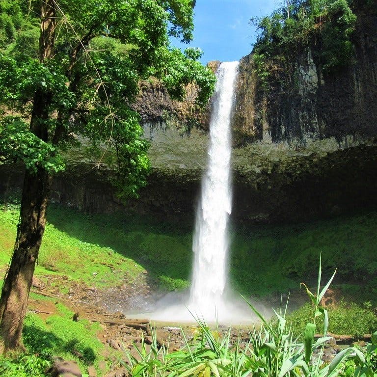
At the ‘hip’ of Vietnam, just as the country swings eastward out to sea below its central axis, Quảng Ngãi is a province with a rich and diverse landscape connected by good, seldom used roads. And yet, travellers tend to skip Quảng Ngãi. With the possible exceptions of Lý Sơn Island and Sơn Mỹ memorial (commemorating the victims of the Mỹ Lai massacre committed by US troops in March, 1968), Quảng Ngãi doesn’t make it onto many foreign visitors’ itineraries. But this is a mistake, because Quảng Ngãi in one of those central provinces that feature a dramatic transition from tropical coastal plains to temperate highlands within a very short distance; the two contrasting zones linked by spectacular mountain passes. Thus, in a relatively small area, there’s an astonishing variety of scenery: from sapphire-coloured fresh water streams flowing through alpine forests, to long stretches of sandy beach punctuated by volcanic bluffs, to lofty, jungle-fleeced mountains breaking the cloudline and agricultural valleys shimmering green in the sun. Very few road-trippers bother to spend more than a day riding through this province, but the Quảng Ngãi Loop is worth 2-4 days of exploration. The roads are good, the scenery is excellent and there’s no one else around.

[Back Top]
QUANG NGAI LOOP
Tropical Plains to Temperate Highlands at the ‘Hip’ of Vietnam
This loop starts and ends at the riverside city of Quảng Ngãi, the provincial capital, which has a train station, bus station, and domestic flights to/from Chu Lai Airport. Instead of writing this motorbike guide in specific sections, I have created a route map, written a brief overview and useful information, followed by a gallery of photos with annotations and links to the map, so that riders can decide for themselves how to organize their itinerary on this 455km loop. The Quảng Ngãi Loop can be ridden in 2-4 days as a standalone loop or as a detour from longer routes, such as the Trường Sơn Đông Road or Beach Bum Coast Road. In addition, Sa Kỳ Port is at the eastern edge of the loop, which means riders can easily add Lý Sơn Island to their Quảng Ngãi itinerary. There’s accommodation in most settlements marked on my map, some of it modest, some very good. The best time is March-August.
CONTENTS:
ROUTE MAP:
Quảng Ngãi Loop | 455km
Blue Line: Main Loop | Red Lines: Alternative Routes
*Road Safety & Disclaimer: Riding a motorbike in Vietnam – or anywhere in the world – has its dangers. I would hope & expect anyone who chooses to pursue a self-drive road trip based on the information on this website does so with care, respect & due diligence. I encourage careful riding & adherence to road rules, but I am not responsible for the legality or manner in which you ride, nor any negative consequences which may result from your decision to ride a motorbike in Vietnam: you do so at your own risk. Read more >

Overview & Details:
Below is a brief at-a-glance overview of the Quảng Ngãi Loop, followed by more specific details about important considerations, such as accommodation, traffic, food and drink, weather conditions, duration and more:
QUICK DETAILS:
- Route: a loop from coast to mountains showcasing the variety of landscape & excellent roads of Quảng Ngãi Province
- Distance: 455km (complete loop)
- Duration: 2-4 days
- Scenery: valleys, rivers, mountain passes, jungles, pine forest, lakes, beaches, agricultural plains
- Attractions: spectacular roads, river & sea swimming, waterfalls, mountain lodges, tropical beaches, remote villages
- Road Conditions: good paved roads & narrow back-roads, light traffic, some rough patches
- Best Time: March-October

About the Loop:
Start & End: I’ve chosen the Trà Khúc roundabout on the banks of the Trà Khúc River in central Quảng Ngãi city as the start and end point of this loop, but you can of course join the loop at any point.
Itineraries & Sections: The loop can be ridden in either direction: clockwise or anticlockwise. You can take as much or as little time as you like on the loop, but a good way to plan it is to spend one day/night in the mountains and one day/night on the coast. For example, on day 1 you could ride from Quảng Ngãi city into the mountains going clockwise on the loop and stay at Dak Drinh Lodge. Then, on day 2 you could continue on the loop through the mountains and back down to the coast and stay at CocoLand River Beach Resort, before returning to Quảng Ngãi city the next day and completing the loop.

Connecting Routes: The Quảng Ngãi Loop can be ridden as a standalone route or as a connection or extension of a number of other routes. For example, this loop could be treated as a detour from the Beach Bum route or the Trường Sơn Đông Road. Another natural extension of this loop is to continue due west on QL24 deeper into the highlands to the pine-studded retreat of Măng Đen and the pleasant mountain town of Kon Tum.
Duration: I’d recommend between 2-4 days to fully explore and appreciate this loop. This would give you enough time to stop overnight once or twice in the mountains and on the coast, thus making the most of the two very different regions that this loop connects. 2-4 days also gives you time to soak up the views, stop for swims, and explore potential side routes.
Traffic & Road Conditions: Outside of Quảng Ngãi city there is very little traffic on any of the roads on this loop. In the mountains especially, you will have the roads essentially to yourself. On the coast and plains there are more vehicles on the roads, but traffic is still very light. Road conditions are mostly very good, but there are some short sections of bad surfaces and mud.
Gas Stations: All towns and villages on the loop have at least one gas station. But don’t let your tank get too low before filling up, because there are some stretches of mountain road, particularly the stretch on the western flank of the loop between the Vi Ô Lắc Pass and Bắc Trà My, that have very few opportunities to fill-up.

Weather & Time of Year: The best months to ride this loop are spring and summer (March-August) when the landscape is green, the colours vivid, the rivers blue, the ocean calm, and the heat is, well, hot. During these months there’s still a high chance of heavy showers, especially in the mountains from the west. October to February can be surprisingly cold in the highlands and surprisingly bleak on the coastal plains. However, these conditions do add a sense of theatre and mystery to the mountains, which are often shrouded in mist and extremely dense fog.
Accommodation: Quảng Ngãi City has lots of different accommodation to choose from: you can browse many of them on this page. Out on the loop, every settlement marked on my map has at least a couple of local guest houses (nhà nghỉ) and there are also a couple of great places to stay: Dak Drinh Lodge on a remote lakeshore in the mountains, and CocoLand River & Beach Resort on the coast. I’ve marked these are several other accommodations on my map, but there are many more available.
Food & Drink: Regional specialities include cơm gà (chicken rice) and many famous Central Vietnamese dishes, such as mì quảng noodles, that are available in most settlements on the loop. Seafood (hải sản) is plentiful along the coastal stretch, but in most of the small towns in the highlands you’ll find cơm-phở (rice and noodle) eateries to fill you up at mealtimes.
Photos of the Loop:


*Disclosure: I never receive payment for anything I write: my content is always free and independent. I’ve written this guide because I want to: I like this route and I want my readers to know about it. For more details, see my Disclosure & Disclaimer statements and my About Page


Great route very interesting
Thanks, Paul!
Best,
Tom
Part of my upcoming summer route from Saigon to Hanoi (by way of Vung Tao, the coast, Dalat, etc) is a detour from Kon Tum to Hoi An. What route would you recommend?
Hi Chris,
For Saigon to Hanoi routes, please see this guide.
From Kon Tun to Hoi An, I’d either take the Ho Chi Minh Road up to Dak To and then turn onto QL40B down to Tam Ky and along the coast to Hoi An, or you could also join the Truong Son Dong Road and take that.
Best,
Tom
I was an Army combat engineer in 1970 out of Chu Lai. I spent quite a bit of time on the road around Quang Ngai, particularly on roads going East of of A1, towards the My Lai area. Thinking about visiting the area with my wife soon but we might be a bit too old for motor bikes. Any other suggestions. Please contact me directly.
Hi Ron,
You can usually arrange to hire a private car and driver (foreign visitors are not allowed to self-drive in Vietnam) through your accommodation when you are here. The cost is usually around $100 per day.
Best,
Tom
Thanks. Do you live in Vietnam now?
Yes, I do. There’s more about all of that on my About Page.
Tom
Hi Tom,
Love your website – use it often. I am going to do this loop this weekend (with some modifications). Question: is the waypoint you have pinned for Song Tranh lake the exact spot where you got that epic sunset photo? Would love to visit there (though I understand if you wanted to keep it “secret” 😉 Please let me know, thanks!
Rich
Hi Rich,
It’s not the exact spot where I took the photograph, but it doesn’t matter – there are lots of good views of the lake from that road. I hope the weather’s good.
Best,
Tom
Hi Tom, received a link to your emailgroup from a friend here in Da Nang. Living here now and as being a huge motorbike freak I am mighty impressed of your knowledge. Need to be part of this.
Hi Bo,
Thank you! I hope you enjoy exploring some of the routes here.
Best,
Tom
Great article, Tom. I hope to be back in Vietnam this year, doing some beta testing for a software education system for folks without internet (but who have cellphones) in rural areas such as Quang Ngai. Your article (and others about rural northern Vietnam) comes in very handy. Much obliged.
Having ridden over a brick on a scooter in Da Nang a few years ago, I will probably try to hire some sort of car rather than motorbike to get around with.
Hi John,
Glad to hear that. Good luck with the project!
Best,
Tom