

Last updated October 2020 | Words and photos by Vietnam Coracle | Read time 25 minutes | 40 comments
This post was last updated 5 years ago. Please check the comments section for possible updates, or read more on my Updates & Accuracy page.

Tom Divers is the founder and creator of Vietnam Coracle. In 2005 he moved from his native London to Vietnam, where he has been living, working and travelling ever since. He pays rent in Ho Chi Minh City but is more often on the road, riding his motorbike a quarter of a million kilometres across Vietnam to research guides to the farthest-flung corners of the nation. When he’s not in the saddle, you’ll find him on a beach with a margarita, in a tent on a mountainside or at a streetside noodle house: in other words, at the ‘office’. Read more about Tom: Q&A, About Page, Vietnam Tourism website.
Sublime Scenery & Joyful Riding in & around a National Park
[Get the complete Offline Guide & Map Package for $15]
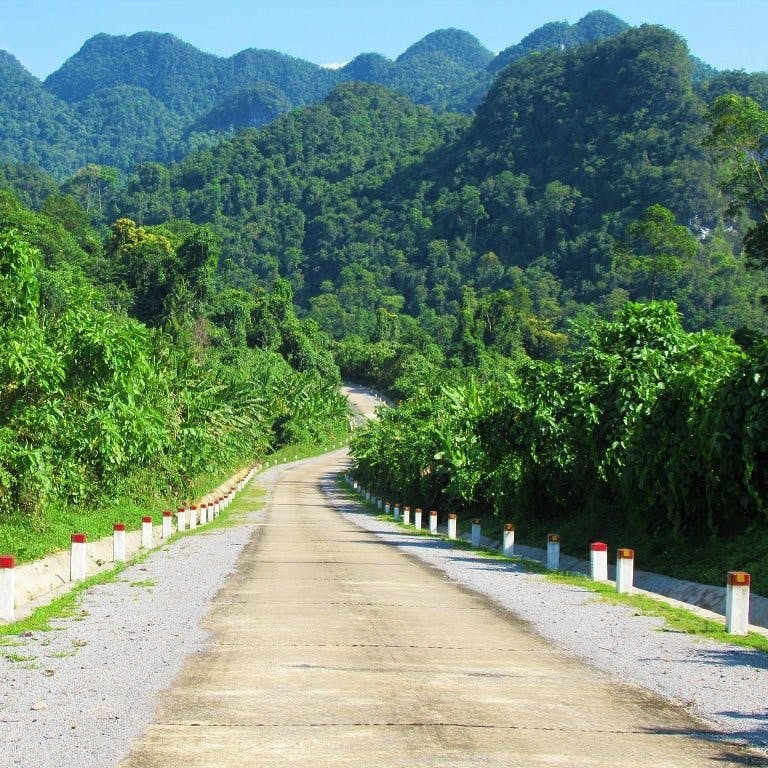
The landscape around Phong Nha, in Central Vietnam’s Quang Binh Province, is some of the most sublime in the country. The limestone karsts of Phong Nha-Ke Bang National Park, whose jagged, jungled peaks extend all the way to the Lao border, provide a quintessentially exotic backdrop to oceans of rice paddies that spread between languid, blue rivers around the village of Phong Nha, on the plains. Over the last few years, the road network through this incredible landscape has improved markedly. Dirt roads have been paved, back-roads widened, old roads upgraded, highways extended, and new roads constructed. It’s ideal for a motorbike road trip. And yet, outside of public holidays and peak times, traffic is still very light, and, although visitor numbers to the area are increasing, most people tend to stick to an established route, leaving the greater Phong Nha area practically deserted and ripe for independent exploration. In this guide, I’ve mapped and described five different routes and loops in the Phong Nha region. Each loop can be ridden separately or stitched together to form a ‘Great Phong Nha Loop’. Providing you have good weather, I don’t see how it’s possible not to fall in love with Phong Nha if you spend a few days riding around on two wheels. I’ve been coming here for 10 years: every time it leaves me breathless.

[Back Top]
PHONG NHA: 5 ROUTES & LOOPS
In this guide, I’ve mapped, described and illustrated five motorbike routes and loops in the Phong Nha area. On the main map, I’ve plotted all five routes in different colours. However, each of the five routes also has its own separate map, which has much more detail, including road conditions, places to see, eat, and drink. Any of these five routes can be mixed and matched and stitched together as and how you like, in order to create longer or shorter loops. Find suitable accommodation in Phong Nha and make it your base for at least a few days while exploring the wider region by motorbike (or bicycle). Ideally, I’d recommend riding all the routes and loops in this guide. What’s more, I’d suggest riding them in the order in which they’re written: starting with Routes 1, 2, and 3, which are gentler rides covering many of the main attractions in Phong Nha, and finishing with Routes 4 and 5, which are longer, wider loops, taking you more off the beaten path. The best time to visit Phong Nha is March to September, when the weather is generally good. October to February can be quite bleak.

- ROUTE 1: Caves & Country Loop (50/90km)
- ROUTE 2: Bridges & Back-Roads Loop (40km)
- ROUTE 3: Bong Lai Valley Loop (15km)
- ROUTE 4: Ho Chi Minh West is Best Loop (290km)
- ROUTE 5: King Kong Loop (190/220km)

Support My Work
Free | Independent | No Sponsored Content
“Hello, if you enjoy my website, please support it.
Thank you, Tom.”
MAP:
Phong Nha by Motorbike: 5 Routes & Loops
Route 1: 50/90km | Route 2: 40km | Route 3: 15km| Route 4: 290km | Route 5: 190/220km
[Get the complete Offline Guide & Map Package for $15]
View in a LARGER MAP
ROUTE 1: Caves & Country Loop
[Get the complete Offline Guide & Map Package for $15]
DETAILS:
- Route: a classic loop of the national park’s main attractions, plus an optional side route
- Distance: 50/90km
- Time: half-day or full-day
- Scenery: blue rivers, spectacular caves, forest walks, waterfalls, jungle, limestone karsts
- Road Conditions: good, smooth-surface roads, light traffic
ROUTE MAP: Caves & Country Loop (50/90km: blue/red route)
View in a LARGER MAP
DESCRIPTION: This is the classic Phong Nha-Ke Bang National Park loop: an easy-to-ride, easy-to-navigate, and highly scenic route on good quality roads around many of the main sights, caves, and activities on offer in the area. One day is enough to complete the loop, although if you want to visit and explore all the sights, you might need two days. You can ride the Caves & Country Loop in either direction, but I prefer going clockwise: starting from Phong Nha village and heading due south on Road DT20. The main loop (the blue line) is only 50km, and it’s easy to follow, fun to ride, and packed with things to see and do. I’ve marked many of the sights and activities on my route map. These include: hiking around Nui Doi semi-wild enclosure; scrambling through the jungles and waterfalls of the Botanic Gardens; kayaking and walking the treetops at Ozo Park; exploring the gigantic, cathedral-like subterranean world of Dong Thien Duong (Paradise) Cave; taking the zip-line and swimming in the astonishingly blue water at Nuoc Mooc springs; getting muddy at Hang Toi (Dark) Cave; and settling down to a delicious, local, barbecue dinner at Quan Binh Hoa, before returning to Phong Nha village for rooftop cocktails at Momma D’s.
In addition to the classic loop around the park, I’ve included an optional side route on Road DT562 (the red line), heading due south, deep into the national park, towards a remote Lao border. On this fully paved side route, which ploughs through extraordinarily dense jungle and wonderful scenery, there are a couple of stops, including the Eight Lady Cave (Hang Tam Co) war memorial, Tra Ang Cave, and the isolated minority village of Arem. Even if you don’t stop at any of the possible attractions on the Caves & Country Loop, the riding and the scenery are sublime. *[Check out my guide to Where to Stay in Phong Nha]
IMAGES: Caves & Country Loop

Caves & Country Loop: enjoying the views of jungle & limestone karsts on Road DT20

Caves & Country Loop: stopping for a refreshing dip in a waterfall in the Botanic Gardens

Caves & Country Loop: excellent riding & fabulous scenery on the Western Ho Chi Minh Road (QL15)

Caves & Country Loop: the breathtaking, otherworldly shapes & formations in Paradise Cave

Caves & Country Loop: the lonely road to remote Arem minority village, near the Lao border

Caves & Country Loop: a sign outside Arem village warns of unexploded ordnance

Caves & Country Loop: looking across to Phong Nha village at dusk, from the bridge on Road QL16

Caves & Country Loop: stopping at Quan Binh Hoa for a delicious BBQ dinner on the way home

Caves & Country Loop: the sun sets behind the limestone karsts of Phong Nha
ROUTE 2: Bridges & Back–Roads Loop
[Get the complete Offline Guide & Map Package for $15]
DETAILS:
- Route: an inner Phong Nha loop on back-roads along the river, local villages & farms
- Distance: 40km
- Time: 2-4 hours
- Scenery: bucolic agricultural river valleys, limestone karsts & local villages
- Road Conditions: decent paved back-roads, some rough patches, light traffic
ROUTE MAP: Bridges & Back-Roads Loop (40km: blue & red route)

View in a LARGER MAP
DESCRIPTION: A quiet, delightfully scenic circuit on mostly paved back-roads and small lanes with a few rough patches, this loop is a rural, local, and laid-back figure of ‘8’ that can easily be completed in just a couple of hours. However, because there are several good swimming spots, food and drink options, chances to meet local people, and lots of lovely vistas across classic Vietnamese agricultural plains, you could easily fill half a day. The Bridges & Back-Roads route features two connecting loops: one around the river east of Phong Nha village; the other around the river west of Phong Nha village. The figure of ‘8’ can be ridden in either direction: clockwise or anticlockwise, it really doesn’t matter. The distances are short, but the loop focuses mostly on small roads, so riding can be quite slow. Also, navigation can sometimes be tricky, so keep checking the route map. This loop is all about farmland, local hamlets, communities, and local life. It’s the most intimate and personal of all the Phong Nha routes in this guide. The scenery is very pretty, but it’s not on a grand scale. Rather, this route is about slowing down, getting off the beaten path, meeting local people, and seeing behind the scenes.
The Bridges & Back-Roads Loop focuses on the agricultural land on the plains surrounding the river, which is crossed on six separate occasions, including a pontoon bridge, a wooden canoe ferry, and three suspension bridges. The character and road conditions change quite dramatically from one side of the river to the other. South of the river, roads are smooth, wide and paved, and the agricultural landscape is dotted with homestays, bars, cafes, and casual dining. In short, this is part of the travellers’ circuit around Phong Nha. By contrast, north of the river, the roads are sprinkled with potholes, dirt sections, and earthen dykes between rice paddies. It’s a very local area without any tourist infrastructure – no hotels, no boutique cafes, no noodle joints with English menus. This, of course, is the whole point, and the slightly rougher edge north of the river can be a relief if you’ve spent too much time on the touristy main drag in Phong Nha village. Local people (many of whom are Catholic, hence the presence of several large and ostentatious churches) are exceptionally friendly: children, men and women all smile and wave you by. In the villages, some of the homes are beautiful wood-and-brick structures. Cattle linger by the road or tethered to bamboo posts in the fields, and it’s fascinating to observe the agricultural work on the land and in the homes. The river, a beautiful seam of clear, vivid-blue water that bisects this loop, is a constant presence. The idea is to linger on this loop, stopping regularly to soak it up. I’ve marked several places – such as, swimming spots, food and drink options, scenic areas, churches – where you might want to stop. Ideally, aim to end this loop at dusk on the river at Bomb Crater Bar, with a cocktail and some tubing on the water as the sun goes down, making silhouettes of the wooden fishing sampans and the karst mountains behind.
Notes: if you take the very short, boggy, off-road section (the red line), then you don’t have to join QL15 at the west of this loop. But if you don’t have an appropriate motorbike or experience, stick to the main route (the blue line) instead. Also note that the ferry and pontoon crossings on this loop require a small fee. *[Check out my guide to Where to Stay in Phong Nha]
IMAGES: Bridges & Back-Roads Loop

Bridges & Back-Roads Loop: this loop features several of these fun, narrow suspension bridges

Bridges & Back-Roads Loop: picturesque scenes of wooden sampans harvesting reeds on the river

Bridges & Back-Roads Loop: this optional ferry crossing is a lot of fun

Bridges & Back-Roads Loop: vivid blue rivers are perfect for swimming

Bridges & Back-Roads Loop: the pontoon toll bridge across the river

Bridges & Back-Roads Loop: riding along the south bank of the river is easy, scenic & quiet

Bridges & Back-Roads Loop: a short optional dirt-road section is fine in dry weather, but muddy if wet

Bridges & Back-Roads Loop: one of the many wooden suspension bridges on a scenic back-road

Bridges & Back-Roads Loop: corn laid out on a farm porch to dry in the sun

Bridges & Back-Roads Loop: cattle tethered to a wooden stake by the roadside at dusk
ROUTE 3: Bong Lai Valley Loop
[Get the complete Offline Guide & Map Package for $15]
DETAILS:
- Route: a short but activity-filled loop of the scenic Bong Lai river valley
- Distance: 15km
- Time: 2 hours to half a day
- Scenery: mountains, rivers, local cafes, farms, food, walks & community based activities
- Road Conditions: decent paved lanes & dirt roads, some muddy patches, no traffic
ROUTE MAP: Bong Lai Valley Loop (15km: blue route)
View in a LARGER MAP
DESCRIPTION: A scenic and short route leading up and down a lush river valley just east of Phong Nha village, this ride is perfect for a relaxing half-day excursion on two wheels. The Bong Lai Valley lies about 7km east of Phong Nha village. Accessed to the south of the Ho Chi Minh Highway, small roads run along both sides of the valley, connected by the Bong Lai suspension bridge, about 2.5km upstream. This creates a lovely, short loop peppered with great stops for food, drink, sightseeing, swimming, tubing, hiking and even farming, among other community based activities. The distances are short, but the things to see, do and eat are many: take your time, soak it up, and fall head over heels for Vietnam’s agricultural, rural charms. You can ride the loop in either direction, but I prefer going anticlockwise, starting on the west bank of the river, on a dirt lane going upstream, and returning on the east bank along a paved lane going back downstream to the main road. This is because it’s best to do the dirt road in the morning, before the afternoon showers, which, if and when they come, can make road conditions slippery.
The scenery is gentle, green, and gorgeous. Unlike the jagged limestone karsts of Phong Nha-Ke Bang National Park, here in the Bong Lai Valley there are rolling hills, fruit trees, crop fields, plantations, and long mountain ridges receding into the distance. The river is clear and good for swimming: join the buffaloes wallowing in the cool water, or rent a tube from the Pub With Cold Beer or Rattan House and float downstream. Take the ride slowly and stop regularly along the way at places like: the Duck Stop, where you can be a farmer for a couple of hours as well as enjoying their bánh xèo (savoury, sizzling pancakes); or the Rattan House, with fine views and a breezy wooden gazebo; or test your nerve (and snap your Instagram photos) on the swings at Nature Farm, which hurl you out over the river valley; or swim in the cool water at O O Lake Silence, among many other potential stopping points. All this should work up a good appetite, which is gloriously satisfied at Moi Moi with a flame-grilled whole chicken, lemongrass pork cooked in a length of bamboo, and bánh lọc – little tapioca dumplings with peanuts steamed in banana leaf. There are also plenty of opportunities for coffee, beer, cocktails, and smoothies: check out the views at East Hill Coffee, or drop into Pepper House Homestay or Lake House Resort for a sundowner. It’s all a lot of fun and the scenery is beautiful. But don’t expect to have it all to yourself: the Bong Lai Valley Loop is a fairly popular and established day-trip for Phong Nha backpackers these days. *[Check out my guide to Where to Stay in Phong Nha]
IMAGES: Bong Lai Valley Loop

Bong Lai Valley Loop: gazing out over the river from the hills behind the Duck Stop

Bong Lai Valley Loop: looking upriver towards the Bong Lai bridge & church

Bong Lai Valley Loop: crossing the metal suspension bridge from west bank to east bank

Bong Lai Valley Loop: a hammock with a view looking downriver to forests & mountains

Bong Lai Valley Loop: entering the Pub with Cold Beer, where there’s great food, drink, views & tubing

Bong Lai Valley Loop: farmland, including cassava, bananas, jackfruit, elephant grass & lemongrass

Bong Lai Valley Loop: a swing with a view at Swing Nature Farm, the southern end of the loop

Bong Lai Valley Loop: preparing the fire for cooking a delicious grilled chicken at Moi Moi
ROUTE 4: Ho Chi Minh West is Best Loop
[Get the complete Offline Guide & Map Package for $15]
DETAILS:
- Route: a dramatic loop south of Phong Nha on the Western & Eastern Ho Chi Minh Road
- Distance: 290km
- Time: 1-2 days
- Scenery: jungles, mountains, amazing limestone karsts, minority hamlets, blue rivers
- Road Conditions: good, very mountainous, paved roads, light traffic
ROUTE MAP: Ho Chi Minh West is Best Loop (290km: blue, purple & red routes)
View in a LARGER MAP
DESCRIPTION: The Western Ho Chi Minh Road, undoubtedly one of the most spectacular roads in the country, leads south of Phong Nha village through sublime scenery near the Lao border. Of all the sections along the 2,000km length of the Ho Chi Minh Road, the west is best. Soaring over limestone peaks, darting in and out of thick jungle, skirting the edges of blue rivers, and with enough hairpin bends to make you dizzy, the Western Ho Chi Minh Road is a real stunner. And yet, there’s hardly anyone on it.
This loop covers roughly 130km of the Western Ho Chi Minh Road, heading south from Phong Nha all the way to Tang Ky junction. The ride along the Western Ho Chi Minh Road is so good that, if you had no choice but to ride back to Phong Nha on exactly the same route, you’d have no complaints at all. However, in the last few years, the three east-west roads (DT563, DT10, and DT16 – the purple lines) linking the Western (the blue line) and Eastern (the red line) branches of the Ho Chi Minh Road, have been upgraded and fully sealed. This means you can now create a loop (or figure of ‘6’, or figure of ‘8’ – whatever takes your fancy) by utilizing any of these scenic, smooth-surfaced east-west roads and connecting them with the Western and Eastern branches of the Ho Chi Minh Road. I’ve marked all of these roads on my route map, but you can mix and match them however you like, in order to create whichever loop you want from Phong Nha and back. But remember: west is best – it’s all about trying to spend as much time as possible on the Western Ho Chi Minh Road between Phong Nha and Tang Ky.
Although the distances on this loop are quite large, if you start early it is still possible to ride a loop from Phong Nha and back in one (very long) day. However, it’s much more rewarding to spend two days riding this loop, by breaking the journey at the only hotel on the Western Ho Chi Minh Road, Duc Tuan Guest House (read more about that here). Also, bear in mind that gas stations are irregular: there’s only really one on the Western Ho Chi Minh Road, located in Long Son village. For other gas stations and other guest houses, you’ll need to head down to the Eastern Ho Chi Minh Road. Make sure you start the day with a full tank; bring your camera, bring your swim stuff, and prepare to be well and truly awed by the Western Ho Chi Minh Road. On my route map, I’ve marked several of my favourite swimming spots, and some of the most scenic areas. [*Check out my full Ho Chi Minh Road Guide]
IMAGES: Ho Chi Minh West is Best Loop

Ho Chi Minh West is Best Loop: the long, weaving, paved route into the jungles south of Phong Nha

Ho Chi Minh West is Best Loop: a high suspension bridge over a river near Long Son

Ho Chi Minh West is Best Loop: threading between two limestone pinnacles

Ho Chi Minh West is Best Loop: staring out over the vast jungles & mountains

Ho Chi Minh West is Best Loop: tropical foliage grows profusely around the road

Ho Chi Minh West is Best Loop: the brilliant-blue Long Dai River snaking through the mountains

Ho Chi Minh West is Best Loop: looking down the valley to Long Son village & the Duc Tuan Hotel

Ho Chi Minh West is Best Loop: through the majestic landscape of Phong Nha Ke Bang National Park

Ho Chi Minh West is Best Loop: excellent riding, extraordinary scenery & hardly any people or traffic
ROUTE 5: King Kong Loop
[Get the complete Offline Guide & Map Package for $15]
DETAILS:
- Route: a big loop north of Phong Nha on roads less travelled, with dirt-road options
- Distance: 190km/220km
- Time: 1-2 days
- Scenery: rivers, jungle, limestone karsts, King Kong filming locations, beach option
- Road Conditions: paved back-roads & highways, optional dirt-road sections, light traffic
ROUTE MAP: King Kong Loop (220/190km: blue/red routes) *[red=dirt-roads]
View in a LARGER MAP
DESCRIPTION: A large circuit north of Phong Nha, the King Kong Loop utilizes some small and spectacular back-roads through jaw-dropping karst scenery, as well as some good highways, with several potential detours and optional dirt-road sections. Certain scenes from the Hollywood blockbuster, Kong: Skull Island, were shot in the landscape to the west of this loop. Although the loop can be ridden in either direction, I’d recommend going anti-clockwise, because this leaves the long, smooth section of the Ho Chi Minh Road (QL15) back to Phong Nha for last: an easy homecoming after a long day’s ride. The King Kong Loop covers a lot of ground with a great variety of landscapes – lush river valleys, desolate beaches, isolated local villages, dense jungle, and limestone pinnacles – but the distances are nonetheless doable in one day, as long as you start at a decent time in the morning. There are two optional dirt-road sections on this loop (the red lines), both of which should be perfectly manageable in dry conditions. But, if the weather has been wet (and especially if you’re not used to riding on unpaved surfaces), these dirt-roads should probably be avoided in favour of the on-road route (the blue lines). The dirt-road loop is marginally shorter in distance (190km) than the on-road route (220km). But, in terms of duration, they’re about the same. A potential side-route is to continue north up Highway QL1A along the coast to Canh Duong (the green line), where there’s an interesting mural village and a decent, local beach. This extension is good if you’re in need of some surf, but not an essential part of the loop.
I’ve annotated the King Kong route map with scenic areas, swimming spots, good riding sections, and some other sights and activities. Highlights of the loop are: the lovely river valley just northeast of Phong Nha, including Thanh Thuy Catholic Church, where the old bell (in the gardens on the north side of the church) is fashioned from a salvaged bomb shell; the excellent scenery along both DT559B and QL12A, including some good swimming spots; and the last 50km on the Ho Chi Minh Road (QL15) back to Phong Nha, which is a glorious ride through terrific scenery, including the steep and spectacular Da Deo Pass. But, best of all, is the ‘mini loop within a loop‘, close to the Tu Lan cave system and the Oxalis Tours drop-off site. Reached via paved roads from the west or dirt roads from the east, this mini-loop winds through an otherworldly landscapes of limestone karsts rising from the floodplains of a river valley. This is where a couple of scenes from 2017 movie, Kong: Skull Island, were shot on-location. In particular, an interrogation scene between the characters played by Samuel L. Jackson and John Goodman, sitting on a wall that is located opposite the Oxalis building. There are a couple of decent cơm-phở (rice and noodle) refreshment shacks nearby this spot. However, bear in mind that, during the wettest months of the year (usually September to November), the entire area can be inaccessible due to flooding. Indeed, households in this valley have two homes: one structure with foundations rooted to the ground; the other lashed to barrels in order to float during the floods. You’ll see the latter waiting patiently in the gardens for the rains to come; at which time the family will move from their home on land to their home on water. *[Check out my guide to Where to Stay in Phong Nha]
IMAGES: King Kong Loop

King Kong Loop: stunning scenery seen from a bridge on Road QL12A

King Kong Loop: a paved country lane – part of the ‘mini-loop within a loop‘

King Kong Loop: riding through the river at the point where the road ends & the dirt begins

King Kong Loop: the back-roads on the ‘loop within a loop‘ are remarkably scenic, empty & quiet

King Kong Loop: this wooden pontoon bridge is rickety & fun to ride across

King Kong Loop: the optional dirt-road section is isolated & fun to ride if you’ve got an appropriate bike

King Kong Loop: roads is this region are getting better & pass through superb landscapes (QL12A)

King Kong Loop: passing along the picturesque river valley, just north of Phong Nha

King Kong Loop: a house for the dry season (left), a house for the wet season (right)

King Kong Loop: gorgeous blue rivers & perfect natural swimming pools along the Ho Chi Minh Road
Disclosure: I never receive payment for anything I write: my content is always free and independent. I’ve written this guide because I want to: I like these routes and I want my readers to know about them. For more details, see my Disclosure & Disclaimer statements here
[Back Top]


Hi, could anyone recommend a place to rent a good-condition scooter (e.g., Airblade)?
Hi Robert,
It should be fairly easy to find a decent place to rent a good scooter in and around Phong Nha. Try by starting with asking at your accommodation and other travellers or take a look at the Phong Nha Visitors Facebook group.
Best,
Tom
I just wanted to let anyone checking these comments know that the road to Laos isn’t in great condition at the moment. There are roadworks all along and lots of loose gravel patches. Some of them have bigger stones mixed in that are pretty hard to see.
Best,
A guy with a little less skin than last week.
Hi Ben,
Thanks for the update. Sorry to hear about the roadworks – it must a been a tough ride. But at least that means conditions will be much better once they’ve finished.
Best,
Tom
I did all 5 of these loops late july / early august ‘25. It looks like the comments here provide much of the updates.
Loop 1: Very nice, enjoyed the road to Laos was some fun riding. Did it over two days to see more attractions. Would not recommend Ozo.
Loop 2: very nice to see kind local people and very relaxing riding. Ferry was not operational when i went on the loop.
Loop 3: i did this one last and with a bicycle. Some of the restaurants are closed now. Enjoyed duck stop and pub with cold beer.
Loop 4: Really enjoyed, if i were to do it again i would probably stay on HCM west the entire time. HCM east is not a very enjoyable ride imo – i got on at the southernmost connector and got back on at the next connector – the riding on this connector is pretty good. I also found the homestay to be very hospitable although the bed was indeed very firm.
King Kong: enjoyed the second half of this loop (counterclockwise) a lot. The riding is beautiful and mini loop is awesome. I would probably try to cut out a lot of the first half if possible (maybe not) because the church is closed and there isn’t too much to see – also a decent amount of crowded roads.
Thank you Vietnam oracle!
Hi Spencer,
Thanks for your trip report and I’m glad to hear you enjoyed the loops!
Best,
Tom
This was a great page to find before getting into Phong Nha.
We ended up spending a day doing route 1 + some exploring surrounds of Phong Nha in general (two bikes with teenagers back seat driving behind mum and dad was interesting!). Stopping regularly and enjoying the sites as well as the view is a must, dont rush. Paradise cave was manic but still nice to see. We intended to do route 2 but ended up doing a trekking tour into e cave through Móc Nam adventure which was great (if you are lucky to get An as your guide her beautiful voice singing in the cave is mind blowing)
The riding was pretty easy on route 1 and you can go at what ever your pace/skill level is. My wife had not been on bike in a fair while but by the end of the day was handling the horn tooting and giving way like a local (except when a bus stuck up behind and blasted it horn from 10m away!)
Thanks for taking the time to write this all Tom, we are already trying to figure out when we will be back to complete the other routes.
Hi Michael,
Thanks for the trip report. I hope you will be back again soon to explore some more!
Best,
Tom
We stayed 5 nights in Phong Nha at the beginning of April and rode all 5 loops. We stayed at Little Rock Homestay which I highly recommend. We rented Honda Waves from Motorvina in town because the Homestay motorbikes were pretty old. All of the routes were incredibly beautiful and the red portions of the King Kong Loop are all paved now. We stopped at the Tú Làn Lodge for lunch which I highly recommend, that valley is mind blowing!!! The road to the Arem Minority village has a lot of ongoing construction. We bought gas in the village from a small shop.
Hi Rakhal,
Thank you for the updates, I’m glad to hear you enjoyed these routes.
Best,
Tom
Excellent guides, as always. Did Route 2 today (May 2025) after some very heavy rain in the AM. The red route is now fully concreted, no dirt. And the bridge on the eastern section was upgraded and opened last week as toll-free (apparently thanks to the local church).
Hi Brad,
Thank you for these updates and I’m glad to hear you enjoyed the route.
Best,
Tom
A couple of things to note on the “bridges and back-roads” ride: the “boggy, off-road” red road on the west side of the map is fully paved and delightful (much like the red sections on the “king kong” route). Also, when one looks at Google Maps, it may say that the ferry is inactive or out of service. It’s still going. Great fun.
Hi Chris,
Thank you for these important and useful updates, I appreciate it.
Best,
Tom
I did the King Kong Loop in December 2024.
I rode counter clockwise and did an abbreviated version. At the junction at Mui Dong, went north rather than going east towards the coast. Then, at the Tien Mai junction, I continued straight west towards the “loop within a loop” rather than going north. at the next junction when I reached the mini loop, I went north in order to reach the Oxalis area, then continued onwards back towards Phong Nha.
This entire route is now fully paved (one small section was ripped up because they were doing some fixes).
Sadly, the pontoon bridges are gone… replaced with modern paved bridges.
Still a really magical ride.
Hi Parry,
Thank you for these important and useful updates. It’s good to know the route is still fun to ride. I hope to ride there in April this year too.
Best,
Tom
Today we drove your Bridges and Back Roads. What a wonderful trip that was.
2 minor updates; the red route is now paved too. On your picture of the ferry it looked like a motor boat, but its hand driven my an elderly couple.
Hi Ton,
Thank you for the updates and I’m glad you enjoyed this route.
Best,
Tom
Hi, these tours look great! It’s a bit short notice, but do you have these available in gpx file as well? Would allow me to upload to my watch for easier navigation:)
Hi Ruud,
Sorry, GPX file is not available. But you can get the KML of the map and use it offline: just google something like ‘how to download the KML/KMZ file for a google map’
Best,
Tom
Hey Tom,
This website is so detailed and amazing. I feel so much better and more prepared (and more excited) because of it.
Quick Question: Is there anyway I can view your maps of Google Maps and follow the route?
Thanks.
Hi Aditi,
To use my routes on Google Maps you will need to export the KML onto your device and then open it in the Google Maps app. The process is different depending on your device and OS. So I suggest googling something like: how to export google maps KML file using (device name).
Best,
Tom
Hi Tom,
It is great to read your articles, they are all informative and useful. I am a local in Phong Nha and I would like to suggest some changes because there have been so many changes since the Covid.
1. There is no more Momma D’s rooftop bar as the owner already left. Bomb crater bar is no longer here, either.
2. There are options for the bars in Phong Nha, which are: King Kong Bar, Jungleboss bar, Phong Nha Funky beach (4km away from the center) – an outdoor bar with the largest swimming pool in Phong Nha.
Hope this helps. Thank you and look forwards to your next amazing writing.
Hi Hoang,
Thank you for these helpful updates and suggestions – it’s a great help to me and to other travellers.
It’s very sad that Momma D’s and Bomb Crater bar are no longer in operation. But it’s also good to hear that other interesting places are available. I look forward to coming back to Phong Nha and trying them.
Best,
Tom
It seems that Momma D’s Rooftop Lounge has closed permanently (or at least that’s what Google Maps is telling me). Any alternatives? That place sounded great
Hi Ben,
Yes, that’s probably correct: the owner of Momma D’s left Vietnam not long ago. But I’m sure there are other good places for cocktails in Phong Nha – just ask around when you’re in town.
Best,
Tom
These are great loops. I did the first and parts of the second loop. For the second loop (bridges/back roads), the mandatory ferry crossing on the north side of the river has a steep ramp that is a bit tricky to get up for beginner riders. If you’re not very comfortable on a motorbike, you can make it easier by going from north to south (so you’re not going up the steep part without any room accelerate beforehand — the other side has a much more reasonable ramp). Enjoy the scenery. The loops are fantastic and these are great guides!
Hi Eran,
Thanks. It’s great to hear your enjoyed some of these loops. And thank you for the ferry crossing tip – good advice for riders.
Best,
Tom
update april 2021:
This is a general update and also a specific reply to the question about cycling the King Kong loop.
The whole loop is now quite rideable by bicycle….even on skinny 25mm tires!
The first of the dirt sections (going acw) is mostly smooth dirt (if dry) though the very last part was a bit rough and avoidable if you choose…just head up to the metalled road a bit earlier than the route shows.
The second ‘dirt’ section is now completely paved and with a new bridge! So you can now join all the way to the village where the Oxalis building is on brand new concrete roads.
The distance is however way out….the full loop was 135kms, not 190 as measured on my (accurate) Garmin cycling computer. You can see my ride here:
https://www.strava.com/activities/5181097817/
Ok, thanks for all the info and hope the updates are useful.
Hi Kieran,
Thanks for the useful updates. It’s great to know that the route is paved now.
The distances in my guide take into account the (longer) optional variations on this loop – that’s probably why they don’t match your Garmin.
Best,
Tom
Tom these are amazing routes.
I’m using them as the basis to create cycling routes all over.. things I can drive/bring my bicycle and do single day or multiple day tours. I know you are mainly focused on motorbikes but do you have opinions on the paved surface for cycles at all? Terrible tarmac can ruin a good ride for skinny tires.
Thanks
Hi BC,
On most of the roads for most of the routes the surfaces should be OK for cycling. However, there are some notable exceptions (many of which are marked on my maps for each individual route with roadworks icons).
In particular, parts of the King Kong Loop would be pretty tough on a bike, at least one with skinny tires. And also a couple of short sections on the Bridges & Back-Roads and Bong Lai Valley loops. The Ho Chi Minh West is Best and Caves & Country loops should be excellent for cycling, although the former is very challenging because of many steep climbs, and you need to watch out for slippery sections in the corners if it’s damp or has been raining.
Also, as a disclaimer, the conditions of Vietnam’s roads are notoriously difficult to predict: they seem to be in a constant state of flux: nothing is guaranteed.
I hope this helps,
Tom
we’ve cruised the phong nha region a month ago, exceptionally beautiful region indeed!
The QL15 down south is one of my most memorable drives of the trip, riding through the lush jungle for hours on end without seeing anyone around. magical!
Tom, you’re a rockstar in maintaining this website, i’ve said it before and i’ll say it again, the website has been of great value for planning our trip, endless information. Thank you!
Thanks, Erik.
It’s great to hear you’ve enjoyed this region on two wheels – it really is a superb area to explore.
Tom
Tom
Your insight and information have been so valuable…just completed a 1500km loop…..Hoi an upto phong Nha….managed to do A Luoi to Phong Nha in a day…..was intending to stop in Long son at the Duc tuan hotel but it was shut due to the corovid19……the bum numbing 8 hours or so ride was nothing short of spectacular…I spent a few days in phong Nha following your bridges n back roads and Bong Lai valley route….brilliant river crossings indeed!
The rain came but was part of the adventure although I was happy to be heading back to Hoi an along the coast road via Dong hoi,Dong ha and Hue..
Your guide was with we all the way and I enjoyed reading some of your own personal journeys….you should consider a motorcycle trip to Leh/Ladakh from Manali if you ever get time….very affordable himalaya adventure.
Lastly I read somewhere you were keen on the yamaha nvx155…..you probably have one by now(love yamahas)but you really must consider a honda pcx next time….this was my mode of transport for this trip(i have hired a nvx before)
Once again thx so much for such a comprehensive guide to Vietnam especially for two wheel adventures..
Regards
murdoch
Hi Murdoch,
Great to hear you enjoyed these routes. It’s a shame about the rain, but the climate in that central region is so unpredictable.
Yes, I’d love to ride up in Leh/Ladakh some day – I’ve heard only good things about it.
Thanks for the bike tips – my old Yamaha Nouvo is closing in on 200,000km, but after that I’ll probably be looking for a new bike.
Best,
Tom
Hi Tom,
Route 5: King Kong Loop.
The dirt road on the western side of your map is in the early process of being upgraded to a concrete road. Today I rode it on my Honda Blade without too much problems (but it was dry. Would have been more tricky on a wet day).
Construction on a bridge next to the pontoon bridge just started. The road now under construction with short concrete parts, some construction-rock parts but most still (widened and flattened) dirt road. Nobody could tell me when the road should be finished but by my estimation: late 2020.
The views in the karst-valley where indeed incredible, stunning, out of this world and should not be missed by anyone.
Hi Bob,
Thank you very much for these updates – very useful and good to know.
I’m glad you enjoyed the loop.
Best,
Tom
Brilliant information and links. I love the roads and the great destinations. I have done 4 rides there now and each one just got better each time, let alone each day.
You’re a lucky fella Tom
Thanks, Rory. Great to hear you’ve ridden Phong Nha and loved it too.
Tom