
First published June 2019 | Words and photos by Vietnam Coracle | 28 comments
This post was last updated 6 years ago. Please check the comments section for possible updates, or read more on my Updates & Accuracy page.
INTRODUCTION | GUIDE | MAP | RELATED POSTS
Thanks to several big engineering projects over the years, and the economic and tourism boom of Hoi An, Danang and Hue, there are now four different, highly scenic routes to take between these three great cities in Central Vietnam. Because it’s nearly impossible to choose between each route, I’d recommend taking at least two of them, thus creating a loop (or, even better, take all four of them and turn it into a figure of ‘8’). Whether it’s a one-day, one-way road trip, or a week-long, full-on exploration of all the routes in this guide, riding between Hoi An, Danang and Hue is hugely rewarding, relatively easy to navigate, and a joy to ride. The topography between Danang and Hue is characterized by an east-west spur of the Truong Son Mountain Range. Branching off from its north-south course along almost the entire length of the country, this mountainous spur drives a wedge between Danang and Hue, creating a dramatic barrier, both physical and climatic. As the spur ploughs eastward, it looms over the gentle farmland and river valleys of the coastal plains, before plunging to the sea. Within a relatively small area, the landscapes are incredibly diverse and very beautiful: from towering, mist-shrouded peaks cloaked in thick jungle, to serene, pretty fishing villages sprawled along sandbars spreading into the East Sea.

There are 4 routes between Hoi An, Danang & Hue: the Coast, the River, the Mountains & the Tunnel
[Back Top]
GUIDE: HOI AN→DANANG→HUE BY MOTORBIKE
This guide is a short introduction to four different routes between Hoi An, Danang and Hue. All four routes can be ridden in either direction, and any of them can easily be stitched together to form a loop or a figure of ‘8’. Thus, you can create a round-trip between Hoi An, Danang and Hue without having to backtrack on the same roads. I’ve named each of the four routes, written a brief description of each one, and plotted them all on my colour-coded map. Weather conditions during the months November through February can be quite bleak. Therefore, try to ride these routes between March and October. As mentioned, you could spend as little as one day or as long as one week riding these routes. On my map, I’ve marked some places of interest along the way, and all of the places marked with a red pin have at least some form of accommodation. (For more ideas about how to extend any of these four routes, take a look at the Related Posts.)

Click an item below for more details:
CONTENTS:
MAP:
Hoi An→Danang→Hue:
Coast 135km | River 125km | Mountains 270km | Tunnel 95km
View in a LARGER MAP
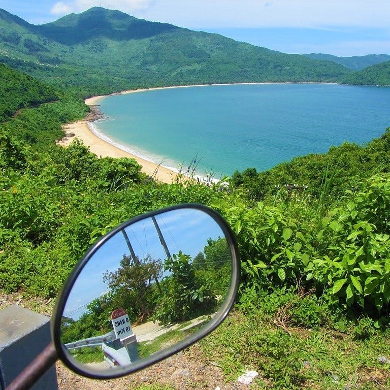
ROUTE 1: The Coast
• Blue line [MAP]:
- Route: the classic Hai Van Pass ‘Top Gear’ route
- Distance: 135km (Danang→Hue)
- Time: 3-5 hours
- Scenery: ocean vistas, the Hai Van Pass, forests, lakes, fishing scenes
- Road Conditions: good surface, few rough patches, light traffic
Description: This route uses the Hai Van Pass (known to many as “one of the best coast roads in the world”, thanks to Jeremy Clarkson’s words in the 2008 BBC Top Gear Vietnam episode) to bridge the mountainous spur separating Danang and Hue. The pass is spectacular and the views are excellent. But this is only part of a much longer, scenic, coastal route, which continues after the pass on several quiet, paved, pretty back-roads through farmland and fishing villages, along coastlines, lake shores and lagoons. After the multiple twists and turns of the lofty Hai Van Pass, the route descends to Lang Co Beach and immediately turns off onto a back-road skirting Lap An Lagoon, then crossing the highway out to Chan May bay, before briefly joining Highway QL1A and quickly turning off onto yet more back-roads, this time leading around Cau Hai Lagoon. From here, the route cuts through agricultural landscapes dotted with wading buffalo and conical-hatted farmers, and mile upon mile of traditional cemeteries in the Hue imperial style. Finally, at Thuan An beach, the route heads south to the centre of Hue. (For full details on this route see my Hai Van Pass Guide.) [MAP]
Images of the Coast Route:


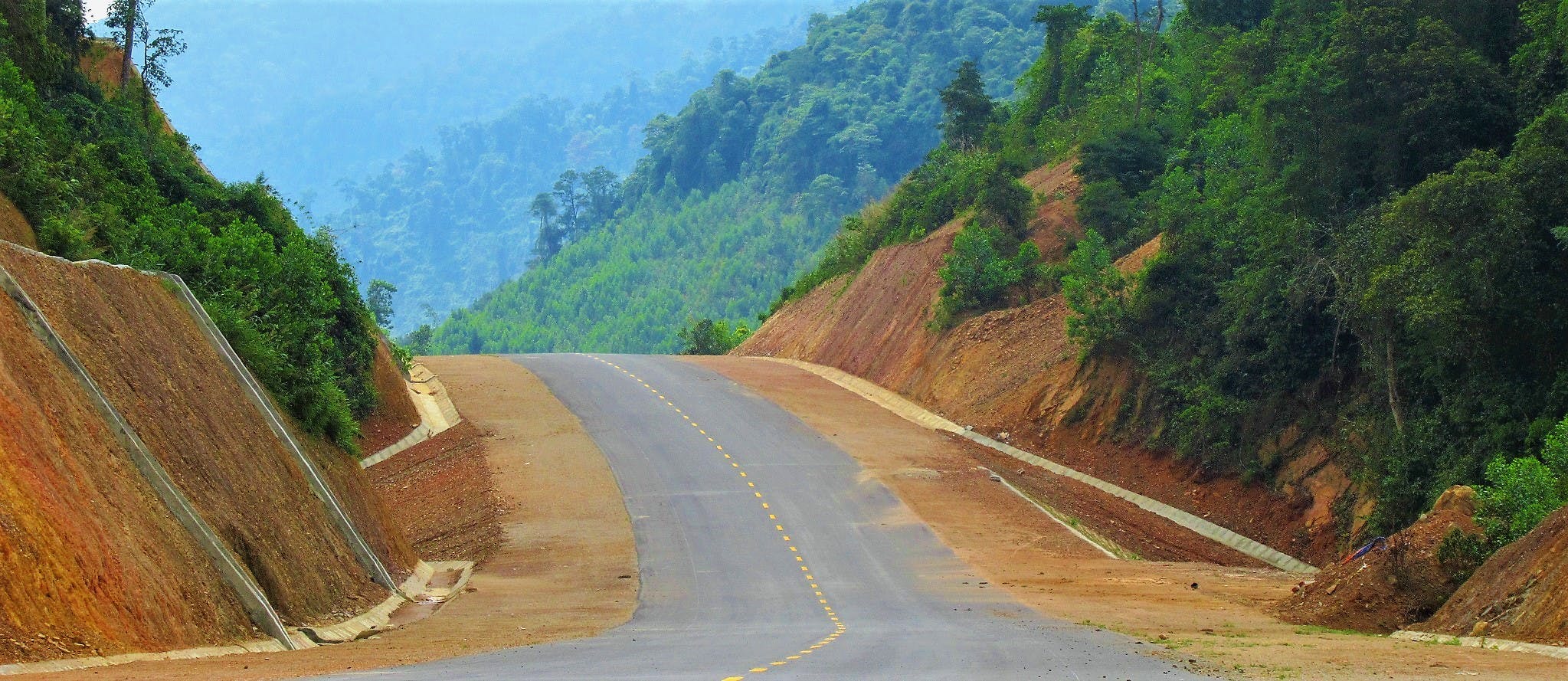
ROUTE 2: The River
• Orange line [MAP]:
- Route: the new, ‘middle’ route, leading behind Bach Ma National Park
- Distance: 125km (Danang→Hue)
- Time: 2-3 hours
- Scenery: green valleys, clear rivers, jungle, mountains, crop fields
- Road Conditions: brand new surface, smooth, light traffic*
*IMPORTANT NOTE: There’s speculation that this brand new road may ban two-wheel traffic in the future. As of June 2019, motorbikes & bicycles are allowed, but check before you go.
Description: Recently completed, this new route is both scenic and fast. By taking a westerly course, going inland behind Bach Ma National Park, the new road bypasses both the Hai Van Pass and the Hai Van Tunnel. Smooth, wide, and newly surfaced, this route follows the Cu De River valley, before going under the mountains of Bach Ma National Park (by way of the Mui Trau Tunnel), and out the other side through crops and tree plantations, then dropping down to the coastal plains and joining Highway 1 for a brief stint into Hue. This route is so new that, at the time of writing (June 2019), much of the central section wasn’t yet shown on Google Maps (I’ve drawn it on my map as best I can). This brand new ‘middle way’ – between the mountains of the Ho Chi Minh Road to the west and the coastline of the Hai Van Pass to the east – has opened up a whole new swathe of countryside. At the time of writing, the entry ramp for the new road (at this junction with Highway QL1A) was unfinished, but motorbikes could easily skirt up the short dirt ramp instead. [MAP]
Images of the River Route:


ROUTE 3: The Mountains
• Red line [MAP]:
- Route: the spectacular, off-the-beaten-path route via the Ho Chi Minh Road
- Distance: 270km (Danang→Hue)
- Time: 1-2 days
- Scenery: big mountains, rainforest, valleys, minority villages
- Road Conditions: good, paved surface, some concrete slab sections, light traffic
Description: The longest, most scenic, and most deserted of all the routes between Hoi An, Danang and Hue, the Ho Chi Minh Road is a spectacular, mountainous ride through some of the best scenery, and on some of the best roads, Vietnam has to offer. From the pretty, coastal plains and the agricultural valleys at the foothills of the Truong Son Mountain Range, to the thick, steamy jungles and soaring peaks along the Lao border, this route is bound to leave you gawping by the roadside, staring in disbelief at what you’re seeing. What’s more, for some unfathomable reason, hardly anyone else is there to see it. It’s best to ride this route over two days (or even three), breaking the journey in Prao for a night. You could potentially ride it all in one day, but you’d have to start very early, ride many hours, and have plenty of riding stamina to do so. Road conditions are generally good, even though the terrain is exceptionally mountainous. Heading west of Hoi An or Danang, there are a couple of different route options: The southerly route skirts a picturesque river valley along road QL14B before joining the Ho Chi Minh Road (QL14) at Thanh My; the northerly route follows road QL14G around the back of Ba Na Hills all the way up to the Ho Chi Minh Road at Prao, thus cutting out the section of the Ho Chi Minh Road between Thanh My and Prao. Both are excellent routes, so which you decide to take will be based on how much time you have. Either way, as you head west of Hoi An and Danang the gentle valleys quickly morph into wild nature and lofty heights as you approach the Ho Chi Minh Road. The section between Thanh My, Prao, and A Luoi offers superb riding and scenery, and you’re likely to have the road practically all to yourself. In short, this is the rider’s route, the nature lover’s route, the epic route: this is the route you shouldn’t miss. (For more details about this route, see section 4 of my Ho Chi Minh Road Guide.) [MAP]

Images of the Mountains Route:


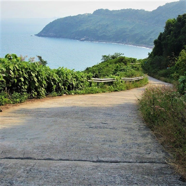
ROUTE 4: The Tunnel
• Brown line [MAP]:
- Route: the direct route on Highway QL1A via the Hai Van Tunnel
- Distance: 95km (Danang→Hue)
- Time: 2-3 hours
- Scenery: mountains, coastal plains, highways
- Road Conditions: good surface, fairly heavy traffic
Description: By far the shortest but least interesting and most traffic-filled of all the possible routes between Danang and Hue, riding Highway QL1A is easy, straightforward and quick. The main feature on this route is the 6.3km-long Hai Van Tunnel, the longest in Southeast Asia. Completed in 2005, the tunnel was an essential engineering project to reduce travel time and traffic between Danang and Hue, all of which previously had to crawl over the Hai Van Pass. At only 95km, Highway QL1A is the fastest link between the two major cities on the central coast. With a journey time of just a couple of hours, this direct route is convenient but not especially scenic. There’s still a bit of eye candy (especially between Lang Co Beach and Cau Hai Lagoon), but compared with the other route options in this guide, it’s nothing remarkable. Highway QL1A is the route that most trucks, buses, private cars, and business vehicles take: anyone whose main purpose is simply getting from A to B as quick as possible, and for whom the journey isn’t the goal. For motorbikers this route does have a major inconvenience: two-wheeled vehicles (as well as petrol tankers) aren’t allowed through the Hai Van Tunnel. However, there is a regular shuttle truck which takes motorbikes and bicycles through the tunnel for a fee of around 30,000vnd (just over $1). The shuttle operates throughout the day (and, on a reduced schedule, at night) and is apparently very efficient, but I’ve never taken it myself, so I can’t vouch for it. One more thing to note is that the tunnel closes daily for 30 minutes between 1.15-1.45pm for maintenance. [MAP]
Images of the Tunnel Route:


Disclosure: I never receive payment for anything I write: my content is always free and independent. I’ve written this guide because I want to: I like these routes and I want my readers to know about them. For more details, see my Disclosure & Disclaimer statements here
[Back Top]


Oh no, my mistake. Last weekend, without thinking, I took the Orange Road (Giang Vo). There were no motorcycles at all, and the passengers in passing trucks and cars said something to me, but I couldn’t understand them.
Later, I realized they were probably saying that motorcycles were prohibited. However, there were no restrictions at the entrance ramp. My mistake was not seeing the comments about this earlier.
This road is still off-limits to motorcycles, and after riding about 15 km, I was stopped by an official at the tunnel.
Hi Juhoon,
Thanks for the update. Yes, the orange route is now the expressway and only for cars and trucks, not motorbikes. It’s a pity, because it’s a nice drive.
Best,
Tom
Hi Tom, thanks a lot – once more – for that posting! I can only reinforce what you said regarding the mountain road – definitely worth it!! One should not miss it, and i would also recommend doing it even though one has done the Hai Van Pass – the latter doesn’t come close! After 5000km in VN, QL49 and QL14, particularly the 40km south/east of Ca Vin, have been one of my favorite roads in VN so far: super remote but therefore even more beautiful and well paved!
In case it helps fellow riders: Huong Danh Homestay near Ca Vin is super basic but marvelous, we somehow managed to crash a Ta Oy minority new year’s party and they were super welcoming. But I guess that’s more for the detailed guide which you have linked here 🙂
Hi Marc,
Great to hear that you enjoyed these routes. And yes, the Huong Danh homestay is included in my Golden Loop guide 🙂
Best,
Tom
Update on the new river route which is the orange line- motorbikes no longer allowed in the tunnel! Despite pleading with the staff they would not let us through. We had to turn round and do the tunnel route which was a huge detour and added about 100k to our journey. DO NOT DO THIS ROUTE.
Hi Rosie,
Thank you for this important update. Sorry you had to travel a lot further than anticipated. Oh well, that route was nice while it lasted 🙁
Best,
Tom
Such a shame that this road can’t be done by motorbike anymore. You have been able to go inside the tunnel (of the tunnel route) by motorbike?
Hi Kevin,
You mean the tunnel on the River Route? No, two-wheeled vehicles are no longer allowed through there.
Best,
Tom
Tom,
Are there any motorcycle rentals in Da Nang that you can recommend?
After completing my North West and some Extreme North sections, I will probably ride back to Hanoi and return the XR150. Plan to fly to Da Nang and then rent another bike at Da Nang.
Might want to do the Golden Loop of Central and then return the bike and take the train back to Hanoi.
Thanks
Hi Brendon,
Yes, all the motorbike rental companies that I recommend on this page have shops in Da Nang or Hoi An or Hue.
Best,
Tom
Took the river route during Tet holiday 2022. The expressway is open and there are signs on the entry ramps that no two wheeled vehicles, tractors, and the like are prohibited. Looks like some locals use it as a shortcut from A1 highway to Khe Tre market area but I didn’t see many people on it heading through the national park.
Hi Mike,
Thank you for the update.
Best,
Tom
Thanks for such a great site so I thought it was worth posting an update on this route as I followed a lot of this route last weekend (April 23rd 2021). The new highway does look completely finished but isn’t officially open. Getting on to it from the Hue side was easy using the tarmac on ramp from the DT14B at Huong Phu (if you ignore the sign which basically says it’s closed to all traffic). It is only once you are approaching Danang that there are heaps of sand across the road in 3 places. In each instance, they were easy to get through and even big enough for a car to fit through.
Hi Richard,
Thank you, that’s a valuable update. I would guess that it won’t be much longer until the road opens to traffic (certainly within this year), after which two-wheeled transport probably won’t be allowed along it. Lucky you got to enjoy it now!
Thanks again,
Tom
I just took the river path today and got screwed. They blocked it with dirt because of the covid wave in Da Nang and had to turn around after about 1-hour on the gorgeous road.
On the way back I saw them build another barrier with dirt and rocks. So don’t take the river road for now!
Hi Duy Le Huynh,
Thanks for the update. That’s a shame, but it is inevitable that, eventually when the road ‘officially’ opens, it will be for vehicles only, not motorbikes 🙁
Thanks again,
Tom
Hi Tom,
Any update as to whether the orange route has banned two-wheeled vehicles yet? Planning on trying that route this weekend.
Thanks in advance
Hi Dave,
Apparently, it’s still OK. But it is due to open very soon, so it might be a good idea to search English language Vietnamese news sites for the latest, such as VN Express or Zing.
If you do attempt to ride it, I’d really appreciate an update.
Thanks,
Tom
Tom,
The route was still open when we rode it this past Saturday. Finding the on ramp to get to the highway was a little tricky as it’s still under construction. But once we got on the road it was an absolute dream. Very little traffic & smooth, open roads, and no signs of banning motorbikes from the road (yet).
Cheers,
Dave
Hi Dave,
Thank you for the update – very useful and I’m glad to hear you enjoyed the ride. I hope that route remains open for bikes for a while longer.
Tom
Road is still open and glorious!! The on-ramp at Da Nang is still not finished. All along the road are stacks of rail guard parts, looks like almost finished but who knows, you wrote that post half a year ago already. In the meantime this empty wide road with great sights is a blast!!
Hi Nicolas,
Thank you for the update. (I’m surprised they haven’t finished the ramp yet). But it’s good to know the road is still open to motorbikes, for now.
Tom
Hi Tom,
I am a new travel blogger and I just wrote this detailed review about Bach Ma National Park in Hue, Vietnam, which is very near Hoi An.
This is also a great attraction in Vietnam. Please also take a look at it if you have time.
And if you travel to Bach Ma, I believe you will have a great experience yourself.
Hi Hung Luong,
Thank you for the suggestion. I have intended to visit Bach Ma National Park for the last two years but bad weather stopped me. I hope I’ll get a chance to visit again soon.
Thanks for the information,
Tom
Hi,
Can we sleep inside Bach Ma park?
Hi Tivanne,
Yes, you can. There are some guest houses in the park.
Tom
I did the orange line road yesterday (28/01/2020) from Hue to Da Nang by scooter. It was a fantastic route with no traffic and beautiful scenery. The way to Hue we took the pass and in my opinion this road is more beautiful (and more relaxing). So many thanks Tom, without this blog I would never know about this beautiful route.
Some update about the road:
When we entered from Hue there were signs that it is forbidden to enter the new road by any vehicle. Yet there is some light scooter traffic. We saw few cars but as I will explain now the road has few blockades which are unable to pass by car. I think from Hue you can drive 3/4 part by car till the road blocks start. I am not sure if police can stop you. I never see any road police in Vietnam so I should not worry about it. I did not see a gass station along the road but maybe you can buy at some houses a bottle.
We had a very strange experience along the route. After driving 3/4 part of the new road we drove into an road block. Some concrete big pipes with sand on it. You could drive over the pipes by scooter on one part, yet there was a road worker blocking this specific part with his truck. There few other locals stranded here at the road block on both sides. First I thought his truck broke down. Yet then I realised he was ordered to or intentionally was blocking the road. It was a very strange occurence. The locals did not seem angry or confused. So I guess it was not the first time. After some time one local got impatient and took cash. Then he asked me also to give 50.000 dong. After some talk the road worker took the money and moved his truck and people got to pass. I did not see the other locals paying anything. Right after he moved there were some other scooters arriving which also did not pay. It was funny and strange at the same time. Some people started to smoke the bong of the road worker. In my country this road worker would have a big fight but here in Vietnam it seemed more like some theater play.
Hi Rolof,
Thanks for the information and updates.
That sounds like a strange and eventful ride, but I’m glad you got through alright in the end.
It seems highly likely that, eventually, that particular route (the orange line) will be closed to 2-wheel vehicles.
Thanks again,
Tom