
First published April 2019 | Words and photos by Vietnam Coracle | 28 comments
This post was last updated 7 years ago. Please check the comments section for possible updates, or read more on my Updates & Accuracy page.
INTRODUCTION | GUIDE | MAP | RELATED POSTS
Every great city needs a great escape. In this respect, Danang is spoiled for choice. Not only does Danang have its wide, sandy beach to the east, the Hai Van Pass to the north, and the Truong Son Mountains to the west, it also has the Son Tra Peninsula, a mountainous headland blanketed in forest with beautiful roads rolling around its contours. A mass of rugged, green land at the northern tip of Danang’s municipal beach, Son Tra Peninsula anchors the city to the ocean, but it also shields it from severe weather from the sea. As Danang’s star rises – fast becoming the ‘Rio’ of Vietnam – Son Tra Peninsula checks the city’s urban sprawl and construction boom, as if to say, ‘Stop! Here the development ends: here be nature, here be mountains and forests, the call of macaques, cliffs and coves, centuries-old banyan trees, lofty mountain passes with majestic views, and sandy beaches untainted by concrete high-rises.’ A world in itself, the Son Tra Peninsula offers all of this and more. By far the best way to explore Son Tra is by motorbike. The roads are good, the distances short, but the rewards huge. In fact, this is one of the most scenic stretches of coast road anywhere in Vietnam. A day or two riding the swirling tarmac on Son Tra Peninsula is definitely one of the best things to do in Danang.

Mountains, forests, wildlife, beaches, lofty passes, coast roads: Son Tra Peninsula is perfect for a road trip
[Back Top]
GUIDE: SON TRA PENINSULA, DANANG
Winding around the peninsula like jungle vines around the trunk of an old tropical tree, the road network on Son Tra is surprisingly extensive. Mountains, coast and jungle are all accessible via the peninsula’s steep and meandering paved roads and concrete lanes. I’ve divided Son Tra’s roads into 3 routes (see the Contents below). However, I highly recommend riding all three of the routes on the peninsula, because they’re all fabulous in their own way. Traffic is light but it can get busy on weekends and public holidays. Although the distances are short it will take many hours to complete the routes because the scenery is so good. You can ride all three routes in one, fairly long, and pleasurable day. But it’s much better to spend a couple of days riding around the peninsula to really soak it all up. Make sure you rent a decent bike, because the gradient is very steep in places and some bikes might struggle, especially with a pillion. On my map I have colour-coded each of the three routes so that they’re easy to distinguish. In the guide below I’ve written a separate description for each of the three routes, including information about things to see and do, places to go, stay, and eat. The best time of year is March-September, when the weather is generally good; October-February can be wet, grey and windy.

- The Coastal Loop (30km)
- The Inland Route (18km)
- The Banyan Extension (10km)
MAP:
Blue line: Coastal Loop (30km) | Red line: Inland Route (18km) | Purple line: Banyan Extension (10km)
View in a LARGER MAP
About Son Tra & the Routes:
Here I’ve written a few brief paragraphs about the subjects listed below:

Son Tra Peninsula has a good network of scenic roads along the coast & through the hills
Routes & Transportation: As you’ll see from my map above, I’ve divided the roads on Son Tra Peninsula into three colour-coded routes, which you can piece together as you like: the Coastal Loop (blue line), the Inland Route (red line), and the Banyan Extension (purple line). All three routes are highly scenic, fairly easy to navigate (signage is good), and pleasant to ride. Although Son Tra Peninsula is ideal for exploring by motorbike, you could feasibly do it on a bicycle too, but it’d be a real challenge with all the steep ascents. Without your own wheels it’s not as fun, because you won’t have the freedom and independence to go where and when you please. However, it’s still possible: You can hire a taxi or motorbike-taxi (Grab, for example), or rent a car and driver, to take you from Danang or Hoi An and around Son Tra for the day. But, of course, this will be relatively expensive.

Motorbike is the best way to see & get around Son Tra, although you could do it by taxi or hire car
[Back]
Danang & Son Tra: Danang is a great city with a great future – the world is starting to realize this now. But, as the city has made a name for itself, inevitably the population has swelled, visitor numbers have soared, construction has boomed, and the roads are increasingly congested. Son Tra Peninsula is the perfect quick fix antidote when Danang’s metropolitan appeal starts to wear off. Barely 5-10 minutes from downtown, and you’re in the forests, mountains, and beaches of Son Tra. There are Buddhist temples and shrines, high-end resorts and budget beach camping, seafood restaurants and cafes, gardens and museums, beaches and coves, jungles and wildlife, stunning ocean vistas and city views, peace and tranquility, sea breezes and fresh air.

These days, Danang is a big, impressive city, but congestion is on the rise: Son Tra is the perfect escape

Not 10 minutes from downtown Danang, Son Tra has beaches, mountains, forests, peace & fresh air
[Back]
Environment & Nature: Trash, thankfully, appears to be under control on Son Tra Peninsula, and construction has been limited to a couple of high-end resorts, several hastily-built mid-range accommodations, a huge temple complex, and some seafood restaurants. However, there at least a couple of abandoned, half-built resort projects, and new developments planned for the future. But technically, Son Tra is a protected area. You will almost certainly see some wildlife, especially squirrels and macaques (at least I think they’re macaques), and maybe even the famous and endangered red-shanked douc langur. Exotic birds, butterflies and dragonflies are everywhere, and the jungles are full of giant, old, tropical trees.

Son Tra is a protected area: an impressive jungle canopy includes giant banyans & wildlife, such as primates

Although trash is generally under control on Son Tra, there’s still litter on some beaches & in some forests
[Back]
Safety & Traffic: Although traffic is generally very light (except on weekends and public holidays), the roads can still be dangerous if you’re not careful. On the narrow lanes, particularly in the north and east of the peninsula, there are some potholed sections and gravel in the corners which is treacherous and easy to skid on. The inland road is extremely steep and it doesn’t take much to lose control. Also, when hiking the pathways through the trees and down to the beaches, it’s very easy to slip and twist an ankle or worse. It might feel safe on the roads, but it’s imperative to ride cautiously. I saw dozens of foreign riders on Son Tra without helmets. This is a bad idea on many levels: Firstly, you’re breaking the law of the country in which you are a guest; Secondly, it’s dangerous (although, perhaps if you can’t be bothered to wear a helmet, you get what’s coming to you); Lastly, if you don’t wear a helmet, everyone will look at you and think you’re an idiot. Increasingly, Vietnamese people see foreigners breaking laws or behaving badly and, understandably, resent them for it. Don’t confirm and encourage this image of foreigners in Vietnam: wear your helmet.


Traffic is very light on Son Tra, but the roads are often very narrow & windy with some uneven surfaces
Son Tra was formerly referred to as Monkey Mountain, a name that was popular with Americans during the war. Indeed, Son Tra has long been of strategic importance as the entrance to one of Vietnam’s biggest ports and cities. For this reason, parts of the peninsula are still tightly controlled by the military and off-limits to visitors. I’ve marked such places on my map.

Some areas on Son Tra are restricted access by the military, look out for signs forbidding entry
The Coastal Loop:
• Blue line | 30km [MAP]
As the Coastal Loop is the longest section of the Son Tra Peninsula motorbike guide, I’ve divided it into two: South and North. Click below to read more:

The Son Tra coast road leads around the entire peninsula, creating an excellent loop
Coastal Loop (South): [MAP]
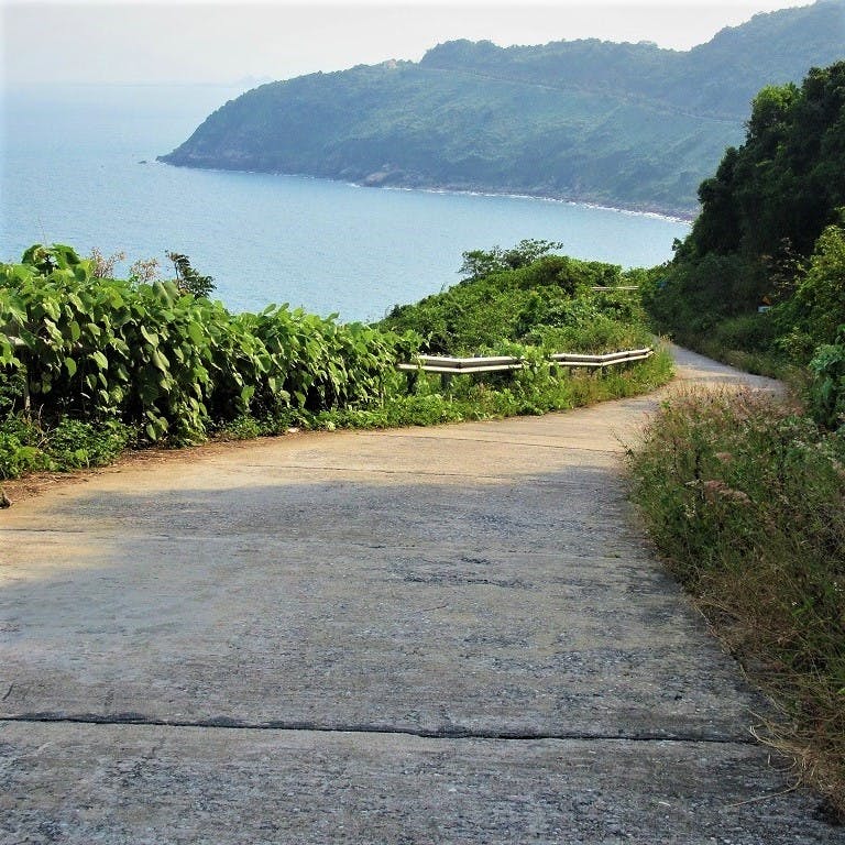
Description & Places of Interest: I’ve written this description of the Coastal Loop going anti-clockwise, starting from the intersection of Le Duc Tho Street and QL14B. This is an excellent coastal route which circumnavigates the entire peninsula (with the exception of the Banyan Extension, see below). The Coastal Loop is easily completed in a day (it’s only 30km) and there are lots of swimming opportunities and things to see. As a general rule, the coast road in the south of the loop is wide, smooth, and in very good condition; but in the north it’s narrow, a bit bumpy here and there, but paved and very manageable. The south coast has some development, but the north coast is almost completely deserted.

The Son Tra Coastal Loop can be completed comfortably in a day with many stops for scenery & swims
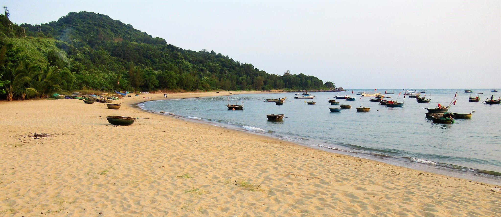
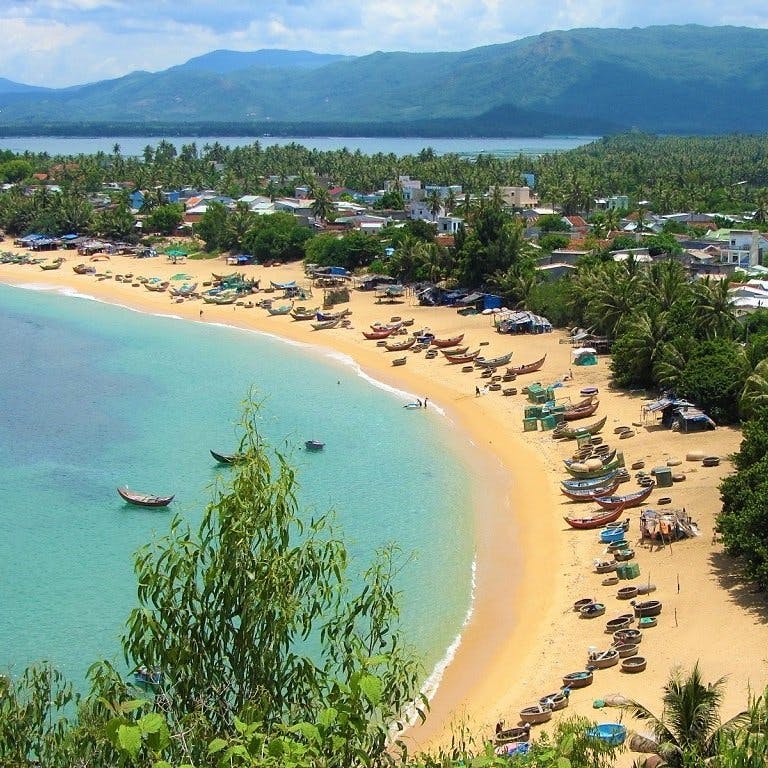
As Le Duc Tho Street heads east it meets Hoang Sa Street at the northern tip of Danang Beach. Here, the city’s high-rise hotels fade away, leaving only a collection of private villas, mini-hotels, seafood shacks, and old fishing homes. A small but picturesque fishing fleet clusters in the shallows, sheltering in the lee of the peninsula. Dozens of woven coracles and wooden sampans ride the gentle surf, with Danang’s increasingly modern skyline behind.

Woven fishing coracles at the beginning of the Coastal Loop, near the northern tip of Danang Beach
Hoang Sa Street is the name of the coastal road stretching all the way around the southern coast of the Son Tra Peninsula. At first, the road turns east, curling around a rocky bluff past a lake and a marina. After just a couple of minutes, the road twists inland, skirting an attractive casuarina-backed beach. It looks enticing, but the beach is currently off-limits: it looks as though it’s awaiting resort development.


Seen from the coast road, this beautiful beach is enticing but off-limits, probably for resort development
On the inland side of the road, a steep lane leads up to the Dong Kinh Museum. With a fascinating and striking gallery of ancient and traditional art and architecture dating back thousands of years, all displayed in an attractive garden setting, it’s worth stopping by this privately-owned museum for a visit if you have the time.
Just beyond the museum, you’ll see the gigantic white head of Phật Bà Quan Âm (the Lady of Compassion) peaking above the trees. A colossal sculpture, the Lady of Compassion is a Buddhist Bodhisattva (like a saint or deity) and her statue is the focal point of the enormous Chùa Linh Ứng temple complex on the hills overlooking Danang Bay. Accessed via a wide and steep concrete road, the views are superb and the temple complex – dotted with fine sculptures, bronze incense burners, pretty antechambers, a tall, terraced tower, and lavishly decorated pagodas with courtyards filled with bonsai trees – is a compelling place to wander around for an hour or so. Note that you must take your shoes off to enter any of the structures, and if you’re wearing shorts or a sleeveless T-shirt, you will need to cover yourself with the robes provided at the temple entrances. It’s a very popular and busy attraction, but it’s still a very worthwhile place to visit. Entrance is free. Some refreshments are sold inside the complex.

Phat Ba Quan Am (the Buddhist Lady of Compassion) is a colossal statue presiding over Linh Ung Pagoda

A giant incense burner in front of Chua Linh Ung, a huge complex of temples, shrines & sculptures
Continuing east along the coast road after the Chùa Linh Ứng temple, there are a series of good beaches and bays stretching all the way to Bai Da, near the southern tip of the peninsula. The most developed part of Son Tra, the south coast beaches are backed by jungled hills and great for swimming, watersports, seafood lunches, and general exploration. The road is wide and good, the riding easy and fun, and the views excellent. The beaches can get busy on weekends, but there’s usually only a trickle of daytrippers during the week.

South of the Chua Linh Ung Pagoda a series of good beaches stretch to the southernmost cape
The first beach after the temple is Bai Cat, a beautiful, long strip of sand with the colossal statue of The Lady of Compassion watching over it. There’s what looks like an abandoned resort here and another one that also looks rather forlorn but is, in fact, active. Accessed by a steep lane from the main coast road, Bien Dong Resort (0236 392 4464) has a prime location at the centre of Bai Cat Beach. But despite having two swimming pools, a beach bar, and thatched beach huts, the complex as a whole is quite rundown. Even so, it’s not bad value for money if you get one of the cheaper garden view rooms for 700,000 (definitely try to bargain on a weekday). Even if you’re not staying here, you can ride down to the beach for a swim and a drink. The other access point for Bai Cat Beach is at the southern end, where Hoang Da Son Tra is a shack by the roadside with a long pathway leading to the sand. The shack sells a few drinks (with excellent sea views) and you can even negotiate camping on the beach for the night. There are tents for hire and it only costs around 100,000vnd per night. However, it might be a bit tricky if you don’t speak any Vietnamese. Ask the staff in the shack and/or call Ms Châu: 0976 113 969.

Bai Cat is a good beach of wide sand where you can swim in the sea & stay overnight

Bai Cat has camping on the beast & accommodation at the rundown but OK value Bien Dong Resort
The next two bays have been developed to varying degrees. The first is Bai Rang Beach, where a series of at least three separate seafood restaurants, cafes, and beach bars line the sand and rocks. Ho Binh (090 510 1318), Bay Ban (090 357 5584), and Bien Dao (093 581 5811) all have access, via very steep pathways and steps, to a good bit of the beach. They’re all good enough for a lunch stop or a quick dip in the ocean and a fresh coconut, but they can all get pretty busy and have trash lying around. (You might also be able to camp here.) The next beach along is entirely taken up by Son Tra Resort & Spa, which is a nice collection of smart bungalows along the sand. Prices start at around $100 a night.

Bai Rang has several seafood restaurants along the sand & rock beach, all with views over Danang
Bai Nam is the last of the sandy beaches before the road rounds the cape and turns due north, and it’s my favourite of the south coast beaches. A brilliant strip of fine sand with a small cluster of picturesque fishing boats and coracles floating at one end, the swimming here is excellent and there’s not much trash around. Bai Nam is generally very quiet, and it’s particularly good for a late afternoon swim, because it faces due west where you can watch the sun set over the ocean and behind Danang’s impressive skyline. At the western end of Bai Nam there’s yet another abandoned resort project. But at the centre of the beach, Vườn Tôi (090 586 8535) offers some food and drink, and fishing and snorkeling excursions. They also allow camping on the beach here, but I was told it’s difficult for them to accept foreign campers. Out in the bay, several floating restaurants serve fresh seafood. At the southern extreme of Bai Nam, Truong Ngoc (097 430 3709) has food and watersports – it’s based on the rocky shores of Bai Da.

Bai Nam is the best of the beaches on the southern coast, with fine sand & good swimming

From Bai Nam Beach you can watch the sunset behind Danang’s rising skyline
After rounding Mui Sung Cape, the coast road glides above the waves, opening up good viewing spots. Take some time to stop by the road and sit under a tree to admire the views over the cliffs and out the sea. The Hoang Sa coast road ends at the Bai Bac intersection. Turn left here, past the tennis courts, and then take a sharp right (due north). This road leads behind the ultra-luxurious Intercontinental Sun Peninsula Resort (which has the lovely Bai Bac Beach all to itself) and begins the northern section of the Coastal Loop (see below).

After rounding Mui Sung Cape the road opens up to big views of the eastern peninsula
[Back]
Coastal Loop (North) [MAP]
Description & Places of Interest: Once past the Intercontinental Resort, the northern coast road soars above the sea, slicing through dense jungle. This side of Son Tra Peninsula is remote, undeveloped, and very peaceful. The jungle canopy shimmers with life. There’s a good chance of seeing some wildlife darting out of the foliage and across the road, including primates, birds of prey, and squirrels. Although the beaches here aren’t really accessible – because they’re very rocky and far below the road – it’s a thrilling ride along a deserted, narrow, concrete-slab lane.

After the Bai Bac intersection, the coastal loop passes the Intercontinental Resort & heads north

The northern coast is remote, wild, rugged: there’s a good chance of see some wildlife here
As the northern coast road ducks in and out of the jungle, past an intersection connecting it with the Inland Route, the mountains of the Hai Van Pass become visible across Danang Bay to the north. Jutting out to sea and often topped with wispy clouds, the Hai Van Pass is one of the most famous roads in Vietnam, and has long been a geographical, cultural, and climatic boundary. The views are terrific and there’s rarely anybody riding this section of road, except for small groups of wildlife photographers with lenses pointing into the canopy, hoping to catch a glimpse of the endangered red-shanked douc. (Because the road is steep and cut out of the mountainside, landslides are possible on this section, especially if there’s been heavy rain recently.)

The northern section of the Coastal Loop is often deserted; the views over Danang Bay are excellent
When the road starts to wind due south, back in the direction of Danang, it runs high above the ocean. Empty and quiet, it’s perfect from 4pm onward, when the sun starts to set on Danang Bay, igniting the city’s high-rises and making silhouettes of the mountains of the Hai Van Pass. A lane leads down to the beaches of Bai Da and Cat Vang, both of which are lovely crescents of sand, dotted with large boulders and backed by jungle. Very scenic and good for swimming, there is, however, quite a bit of picnic trash left behind by visitors.

At the northwest of Son Tra Peninsula Bai Da & Bai Vang are glorious beaches hidden down lanes
As the road continues south, hugging the mountainside above the sea, it reaches the naval base at Tien Sa. Turn right at a military check-point and steeply down to join Road QL14B (Yet Kieu Street). It’s worth turning right again at the main road and continuing to the western tip of the peninsula, where Tien Sa commercial port is located, as well as Tien Sa Lodge, which offers fairly soulless but comfortable, good-value rooms with sea views and a beach. Also near the beach here is the fascinating Y Pha Nho Cemetery. This colonial graveyard holds the tombs of 30 French and Spanish soldiers who died here in 1858, during France’s first attempt at landing and conquering Vietnamese mainland territory. The French were defeated in Danang, and shifted their focus south, to Saigon, which they took and gradually gained control over most of the rest of Vietnamese territory, including Danang. After a visit to the cemetery, turn back on Road QL14B to the intersection with Le Duc Tho Street, thus completing the Coastal Loop.

The coastal loop ends as the road descends to a naval base & Tien Sa commercial port
The Inland Route:
• Red line | 18km [MAP]
Description & Places of Interest: In many ways, the Inland Route is the most spectacular of the roads around Son Tra Peninsula. This is because it leads very steeply up the mountainsides, cresting and following a ridge, and curling all the way to stunning peaks and viewing platforms with immense vistas. At only around 18km in total, it’s a relatively short route, but the scenery is so good that you’ll probably spend an hour or two riding it. I’ve written the following description going from west to east, but you can ride the Inland Route is either direction, and there are several access roads connecting it with the Coastal Loop.

The Inland Route is probably the most spectacular of the roads on Son Tra Peninsula, with lofty views
Starting at the northern tip of Danang’s long beach, take Le Van Luong Street due north. It’s not long at all before the road starts to twist and turn. After a short ascent, Vườn Tre Bamboo Garden is on your right. (The entrance is easy to miss: look out for a bamboo gate in the hedgerow.) A peaceful, contemplative place filled with the sounds of trickling water from mountain streams and cicadas in the brush, Vườn Tre is lovely for a short break with a coffee or a book. The garden is dotted with clumps of different kinds of bamboo with signs identifying each one. There’s a pond full of large fish, and lots of benches and chairs to sit in the shade and while away an hour or so,. Pathways lead through the bamboo groves, between fruit trees, and over rocky streams where little Buddhist shrines decorate the scene.

The first stop on the Inland Route is Bamboo Garden, a shady, peaceful & contemplative place
From Bamboo Garden the inland road slaloms up the forested mountains of Son Tra. At an intersection linking the Inland Route with the Coastal Loop, fantastic views over Danang city and beach start to open up through the trees. Things just get better and better as the road continues to ascend through tight switchbacks to Nha Vong Canh viewing platform. Located at an intersection just beneath the strange, golf ball-shaped radar installations, the views here are mind-blowing. Looking due north across Danang Bay, you can see the famous Hai Van Pass, whose mountainous spine juts out into the infinite blue of the East Sea. Tankers cross the bay, moving in and out of Tien Sa Port, scoring the ocean with trails of wash. (The road up to the radars is a dead-end and accessed is prohibited.)

As the Inland Route twists up the mountainside, massive views open up back over Danang city & beach

Several viewing platforms, such as Nha Vong Canh, offer great photo opportunities over the mountains
Moving east along the inland road, a dramatically undulating section passes by an old helicopter landing pad and another link road to the Coastal Loop, before climbing extremely steeply to Ban Co Peak viewing platform. As high as the road goes (not including the restricted access roads), Ban Co Peak is reached via a flight of winding steps up to a rocky summit where the views are staggering. Looking over the jungled spine of Son Tra Peninsula, out to the East Sea where the Cham Islands look tiny in the vast ocean, and down over the entire length of the long beach stretching from Danang’s impressive skyline past the Marble Mountains to Hoi An, it’s difficult to comprehend the scale of the view you’re seeing. The peak is windy, fresh and cool. The only adornments are viewing gazebos and an incongruous, but nonetheless attractive, sculpture of Confucius leaning on his staff pondering his move in a game of chess. Just beyond Ban Co, a dirt lane leads to a clearing overlooking Danang, which, apart from being a good view point, is a parasailing launch site. After this the road surface deteriorates before an intersection, where your only choice is to descend, because the other two lanes are restricted access.

At Ban Co Peak, an incongruous but attractive statue of Confucius presides over the big views

Ban Co Peak is the highest point that visitors can reach: there’s a viewing platform with huge vistas
From Ban Co Peak, the road narrows for a 7km descent all the way down the mountains to the Bai Bac intersection, near the Intercontinental Resort. Known as Monkey Pass, this is probably the steepest road on the peninsula. It’s in decent condition and very quiet, but be careful in the tight, blind corners. The ride is spectacular, very green, lofty, and fresh. A slip road halfway down leads to a dead-end but with good views. At the Bai Bac intersection you can link up with the Coastal Loop going north or south, or the Banyan Extension route going east.

The Inland Route descends from Ban Co Peak via the steep, narrow, forested & highly scenic ‘Monkey Pass’
The Banyan Extension:
• Purple line | 10km [MAP]
Description & Places of Interest: This route covers the densely forested easternmost section of the Son Tra Peninsula. Remote and beautiful, I’ve called this route the Banyan Extension, because both of the lanes in this area ultimately end at grand, old banyan trees that have stood here for many hundreds of years. Spreading east of the Bai Bac intersection, this route is a scenic extension (it’s only 10km) to the Coastal Loop and the Inland Route.

The Banyan Extension covers the densely forested easternmost section of Son Tra Peninsula
By turning due east at the Bai Bac intersection, a narrow, highly scenic, concrete-slab lane glides through lush foliage above a high cliff. Along the road is a very steep and rocky pathway down to Bai Da, a dramatic, boulder-strewn beach that’s scenic but not great for swimming.

Turning due east at the Bai Bac intersection the road winds around a high cape with ocean views
Turn right at the ‘Banyan Intersection‘ and continue due east until the road dead ends. This is where The Banyan Tree is located (or ‘Banjan Tree’ as it’s written on most maps). This extraordinary tree is apparently over 800 years old. With dozens of thick, twisted roots, trunks and vines plunging from its canopy to the earth, it looks as though the tree were anchoring itself to the ground so as never to be uprooted or cut down. It’s a beautiful sight. Just think what this banyan tree has seen: the fall of the Hindu-Buddhist kingdom of Champa; the rise of the Vietnamese as they pushed south into what is now central Vietnam; the arrival of Arab, Chinese and Japanese merchants on wooden junks; the first Europeans – the Portuguese, the Dutch, the Spanish, the English – and, of course, the French as they landed in Danang in 1858 to begin what would become their most profitable colony in ‘Indochina’; and then the long wars for independence throughout the 20th century. Through all this, the banyan has stood, and continues to stand, on this green, rugged and breezy peninsula, looking out to sea at the comings and goings of peoples, civilizations, and empires.

The Banyan Tree near the eastern tip of Son Tra is grand, beautiful & very old: over 800 years

The eastern tip of Son Tra Peninsula is covered in forest: it’s breezy, cool & fresh: few people come here
Back at the ‘Banyan Intersection‘ you can take the lane heading due north. This leads to the most remote part of the peninsula. At a fork in the road, turn left for a mysterious, overgrown lane leading to a dead end (but there are some good views from it). However, if you continue straight at the fork you’ll reach the entrance on your right for Tien Sa Lighthouse. A very steep lane leads down to the picturesque lighthouse. Built during French colonial times, in the early 1900s, the lighthouse is small but perfectly formed. For 20,000vnd you can climb the tight spiral stairs up to the top and open a small, concealed door to crawl out onto the deck. The views are good and there’s an appealing sense of isolation here.

Tien Sa Lighthouse dates back 100 years to French colonial times: you can climb to the top for views
A bit further along the road, almost opposite the access lane to the lighthouse, is the entrance to Nhat Lam Thuy Trang eco area. A long lane leads through orchid nurseries, ponds, and a wonderful stand of old-growth forest. Rutted pathways lead to a couple of huge old banyan trees, their roots tangled and curled around boulders, forming arches and valleys in their trunks. The most famous tree here is Cây Đa Con Nai (Deer Banyan), so named because its shape resembles a deer. It’s well worth the 10-minute hike through the jungle to get here. There’s a real atmosphere under the canopy, with the breeze through the leaves, and the fresh, peninsular air. If you like it that much, you can rent one of the wooden gazebos over the pond for a night of camping: 500,000vnd. After Nhat Lam Thuy Trang eco area, the paved road continues for a few minutes, leading around a cape with views across to the Intercontinental Resort, before dead-ending.

The ‘Deer’ banyan tree, with its gnarled, twisted roots, is located under an atmospheric jungle canopy
Disclosure: I never receive payment for anything I write: my content is always free and independent. I’ve written this guide because I want to: I like this peninsula and I want my readers to know about it. For more details, see my Disclosure & Disclaimer statements here
[Back Top]


I was up on the mountain this year a few times. Blue outer route still inaccessible.
It’s possible to go in and out of the port side as commented previously.
It is also possible to come out the intercontinental side to complete the smaller inner loop. Last time I did it was probably a couple of months ago or less. There was a makeshift barrier at intercontinental where we made it clear to intercon security we were coming through. Surprisingly friendly this time they even offered to put the barrier that we moved back as they waved us off.
The barrier would though no doubt be enforced for the opposite direction to go up the mountain.
A previous occasion last year saw a “landslide” there blocking entry and exit which was far more challenging to get over! Seems to be some ongoing awkwardness at that point. Wasn’t clear to me how the landslide could have naturally done it’s way there.
I went to the lighthouse in the last few months a couple of times. Not heard of any limit on the banyan tree, but haven’t tried so can’t confirm.
I will update any changes on futures regular spins up there.
Cheers
Hi Martin,
Thank you for the updates. It sure is taking a long time for them to clear the roads up there, but glad to hear most of it is passable.
Best,
Tom
The Blue Coastal Route
Furthest west on this map is closed going via western beaches
The only way up the mountain/peninsula is on the red inland route when approaching from the port/naval base side
Hi Seamus,
Thanks for the update. I hope they reopen the western coast road sometime soon.
Best,
Tom
Hi Tom
Just to update further:
The Northern Coastal Route is also closed
And the inland route beyond Ban Co Peak is also closed
Basically you can ride up to Ban Co Peak past the helicopter landing zone and return the same way. (Not a loop)
You can ride on the eastern coastal route to InterContinental but I’m unsure if you can drive further to The Banyan Tree or Lighthouse at this time
Thanks, Seamus.
Tom
Hi Tom, I can confirm what Kevin said a year ago – routes are still closed from Hang rao da ((16.1128188, 108.3094719)) onwards. Security won’t let you through, and even though the signals only say ‘automatic scooter prohibited’ it seems like no motorized vehicle can pass. We tried our luck around the corner at the intercontinental hotel, but no luck either, as security is blocking all the roads. I have not checked the north/western access to the loop, but in the east it is not possible to continue.
Hi Marc,
Thanks for the update. That is a shame and I hope they will sort this situation out soon, at least by making it clearer and more consistent.
Best,
Tom
Took the Red Line (Inland path) up to Ban Co Peak on the 1st of February (2023), the route is still mostly good and opened to that point. Pass that point, it’s kind of closed and considered dangerous (because of last typhoon damages) by the local authorities in Son Tra, so I had to do the same way back. Does anyone know if the Blue line or the Purple line are opened now?
Hi Kevin,
Thank you for your trip report and updates on the roads there.
It’s a shame all of the routes aren’t open again yet.
Best,
Tom
Hi Tom
I am a big fan of Vietnam Coracle, great job mate.
I live on Le Van Luong just next to the Son Tra mountains and I am a regular visitor to the remoter parts of the peninsula. Whilst your guide is brilliant it is dated in 2 issues.
1. 2 years ago after 2 fatal accidents on the remote single track roads, the Da Nang Govt installed manned barriers in 3 locations and only manual or semi auto mcs are allowed through. The barriers are at Intercont on Hoang Sa, by the Naval station behind Tien Sa port and on the ridge road up to the Checker Man view point.
2. In October 2022 Da Nang had a direct hit by a big typhoon and then 2 weeks later we had 500mm of rain in 6 hours resulting in floods, bridge collapses, roads washed away and landslides. The main beach road near the intersection with Le Van Luong was washed out bit now quickly repaired but access to the peninsula is only possible via HOANG SA as far as Intercont and that is through several serious ongoing road repairs. All of the old concrete roads on the ridge and the North are very seriously damaged, washed away or blocked by landslides. I really dont know what the Govt or the National Park Authority will do as repairs will be costly and demanding of scarce engineering talent.
Right now its easy access to the Pagoda and as far as Intercont is riskier with potholes and fresh landslides when it rains
I will update again when there is better news.
Hi Peter,
Thank you for these valuable road updates – I really appreciate it.
I hope the damages to the roads will be fixed some time in the near future.
Best,
Tom
Hi Tom,
Unfortunately the road is still closed due to landslides.
Cheers,
Silvio
Hi Silvio,
Thank you for the update. Sorry to hear that section of the road is still closed. I hope it will reopen again soon.
Best,
Tom
Recent update from an Aug 2022 visit: it seems that the no autos rule is pretty strictly enforced these days. We entered from the coastal loop at the Tien Sa port end mid-week and were stopped by a security guard at a barrier and refused entry to the peninsula (this is just below the steep ramp up to the base). We managed to arrange a day rental of semi-automatics so disappointment was only short-lived (we’d ridden up from Hoi An so the extra cost was an easy choice). There was a similar set-up at the Bai Bac intersection once we got round there later on. Indeed, all other riders (not many at all) we passed on the northern side of the coastal route were on manuals or semi-autos. We ran out of time to do the inland route so can’t say whether it was the same set-up there.
The north side of the coastal route is spectacular and I am also very happy to say that the Bai Da (North) beaches (the rocky and the sandy one) were in immaculate condition on our visit. I saw hardly any litter (certainly no more than I would see at a remote beauty spot in the UK). I guess that the caretakers staying down there by the parking area are doing a good job of keeping it clean.
Hi Alasdair,
Thank you for these updates – they’re very useful.
It is a shame about the automatic bikes – I must say I don’t really see the logic in that rule. But it is what it is.
Good to hear some of the beaches are in a clean state – I hope that’s a long-term change.
Best,
Tom
Hi there!
Thanks again for a great review! I notice some military checkpoints on this map and some people discussing automatics will be stopped. I have a semi-automatic, however do you know if there will be any problems with police/military checking licenses etc.? Was able to avoid the police in Mui Ne and would like to keep that streak going in Central. Thanks!
Hi Ryan,
If you’re on a semi-auto, riding carefully, and don’t go beyond the military check-points and restricted areas marked on my map then you shouldn’t have any problems on the Son Tra Peninsula.
Tom
As I discovered last time I had my bike down in Danang, automatics are now excluded from much of this area. There are regular signposts as you head round the south-east side indicating how much further you’re allowed to go on an automatic…
Hi Keir,
Yes, thank you for the update. I have heard this before, however I’ve also had readers write me that they have taken automatic scooters around Son Tra recently without any problems. I suppose it just depends whether or not you bump into checks on the road.
Tom
Hi Tom.
The red line seems to be a one-way-road these days from west to east. There’s a signpost at the eastern end of the road (Intercontinental side) saying “một chiều” (one way). A security guard at the Bai Bac intersection also preventing you to turn left.
So for both the blue and red line go clockwise if you wanna do the full loops
Hi Bob,
Thanks for that update – very useful.
Tom
Hi Tom
I read this great article just before heading back to Danang and Hoi An for a weeks holiday. After picking up our scooter for the week we headed to Son Tra. We spent the day exploring the inland route and the coastal route. It was a fantastic days riding and exploring. All within a few Km’s of Danang.
The coastal route was probably the biggest surprise although it proved tricky to find the coastal route until we had the courage to go past the security checkpoint leading up from Yet Kieu Street (we went around clockwise)
As always, your articles are a great read and so useful.
Thanks, Jim. I’m really glad you enjoyed exploring Son Tra on your motorbike.
Tom
I’m headed out there tomorrow. As always, thank you so much for your amazing guides. I don’t know what I’d do without your blog!!
Thanks, Justine. I hope you enjoy it. I was there again just the other day.
Tom
I have lived on Le Van Luong for 1 year now – the peninsula is my back yard – and my solace. I have explored this beautiful forest on every bit of paved road there is, dozens of times over. There are stories in these hills, and I relish my time up there. Every ride, something different. This is a fantastic article with a wealth of information about Son Tra Peninsula, some of which is even new to me. Tomorrow I will go find the Deer Banyon tree. Thanks for a great share!
Hi Allyson,
Thanks, it’s great to hear that. Lucky you living right by Son Tra! Right on your doorstep.
I hope you enjoy the Deer Banyan – lovely old things those trees.
Tom