
First published September 2022 | Words and photos by Vietnam Coracle | 9 comments

Tom Divers is the founder and creator of Vietnam Coracle. He’s lived, travelled and worked in Vietnam since 2005. Born in London, he travelled from an early age, visiting over 40 countries (he first visited Vietnam in 1999). Now, whenever he has the opportunity to make a trip, he rarely looks beyond Vietnam’s borders and his trusty motorbike, Stavros. Read more about Tom on the About Page, Vietnam Times and ASE Podcast.
The Côn Đảo Archipelago is probably the most pristine natural environment in Vietnam accessible to independent travellers. Nowhere else are the jungles so green, the sea so blue, the air so clear and the litter so absent. Several well-maintained, easy-to-follow hiking trails traverse the main island of Côn Sơn as well as a couple of the archipelago’s outlying islets, all of which are part of the Côn Đảo National Park. These trails can be hiked independently, without the need for a guide or any special equipment. Not only are the hikes beautiful – offering wildlife spotting, empty beaches, old-growth forest and sensational views – they’re also a low-impact way of exploring the Côn Đảo Archipelago. Hiking the islands is good exercise, invigorating, inexpensive and, most of all, a wonderful way to see and experience this unique destination.

[Back Top]
HIKING THE CON DAO ISLANDS
Independent Hiking in a Pristine Natural Environment
In this guide, I’ve outlined all the trails currently open to independent hikers on the Côn Đảo Islands. I’ve included a fully annotated map and a Need to Know section with information about tickets, getting to the trailheads, food, drink, weather and safety. For each of the hiking trails, I’ve written a description including at-a-glance details, such as duration, difficulty and scenery. (Note that other hiking trails exist, but were not open to foreign travellers at the time of research.) Click below for details:
CONTENTS:
Trail 1: Plantation Lookout
Trail 2: Love Peak
Trail 3: Bamboo Lagoon
Trail 4: Bang Beach
Trail 5: God Mountain

Support My Website
Free | Independent | No Sponsored Content
“Hello, if you enjoy my website, please support it.
Thank you.” Tom

MAP:
Hiking Trails on Côn Đảo Islands
Need to Know:
MAP: My hiking map shows all the trailheads, sights, national park offices and routes. However, the markers and trail lines are only an approximate indication. Nevertheless, my map and the rest of the information in this guide should be more than enough for anyone to follow the trails independently, without the need for a guide. An official map is available at the national park offices, but it’s pretty useless. Hopefully, it won’t be long before Côn Đảo starts producing a high-quality, annually updated tourist map like the one for Phú Quốc Island.

TICKETS & INFORMATION: Technically, hikers must buy a ticket (60,000vnđ) each time they enter the national park. These can be purchased at any of the national park offices and ranger stations marked on my map. But, in reality, tickets are rarely checked. The National Park HQ and the main office in town both have quite helpful staff, but I get the impression that the staff themselves haven’t actually undertaken the hikes. Therefore, information is a bit vague.
GETTING TO THE TRAILHEADS: Three of the hiking routes in this guide start/end at the National Park HQ just 2-3km north of Côn Sơn town, where most of the island’s accommodation is, which means you can start the hikes from your hotel if you want. Alternatively, take a motorbike, bicycle, taxi or electric buggy to the trailhead and back.

FITNESS, FOOD, FOOTWEAR & SAFETY: All hikes, even the shorter ones, require a moderate level of fitness, partly because the heat and humidity can be punishing, and partly because some of the climbs are pretty steep, requiring a reasonable amount of balance and coordination to avoid slipping on the damp pathways and stones. You must wear decent footwear: trainers (sneakers) are fine; flipflops are not. The paths can be extremely slippery and treacherous, especially when going downhill. Due to the humidity, you need to stay hydrated. Make sure to bring at least one big bottle of water and some snacks for a picnic. I’ve marked several places to buy drinks and snacks in Côn Sơn town on my map. All time estimates in this guide include resting, taking in the views, swimming and general sightseeing.
LITTER, WILDLIFE & ENVIRONMENT: Very few travellers use these hiking trails, yet they are well-marked and maintained. Yes, the concrete trails are a bit incongruous in the otherwise natural environment. But, in general, this is one of the most unspoiled destinations in Vietnam. Unlike every other tourist destination in the country, trash is under control here. Obviously, you should do your best to keep it that way. You will almost certainly encounter wildlife, including large bands of macaques. The national park asks visitors not to feed them. Unfortunately, this request is regularly ignored by tourists. Snakes and mosquitoes are common on these hikes. Bring bug spray and be careful.

WEATHER: Any time of year is fine, but the best months are March-September when the seas are calm and clear, the jungles vibrant and the breezes cool. Rain is always a possibility and will make the hikes much more difficult and treacherous.


Trail 1: Plantation Lookout
HIKE DETAILS:
- Route: Sở Rẫy plantation→Ông Đụng beach→National Park HQ→Ma Thiên Lãnh bridge
- Map: red line on my map [MAP]
- Location: centre-west, Côn Sơn Island
- Scenery: jungle, wildlife, island views, rocky beach, streams, colonial vestiges
- Duration: 3-4 hours one-way
- Difficulty: moderate
There several reasons why this route, usually referred to as the Sở Rẫy hike, is the most popular on the Côn Đảo Islands. Firstly, the views from the plantation lookout are an excellent reward for the physical effort of getting there; secondly, the hike has a good variety of sights, including sea views, mountains, jungles, streams, wildlife and colonial-era relics.
There are two trailheads to Sở Rẫy plantation lookout: one ascends from the south, on Huỳnh Thúc Kháng street, the other from the north, on the west coast road. Both trailheads are clearly signposted from the road. From either direction, the ascent is steep, lush, and humid under a thick canopy of tropical trees shimmering with birds and other wildlife, such as macaques and black squirrels. The pathway is paved and easy to follow, but if the trail is damp it gets very slippery: be extremely careful on the descent when it is much easier to slip and fall. At the top, the land levels out and there are a couple of overgrown structures which are remnants of two plantations: the first, dating from the French colonial period; the second, from the early 21st century, after Typhoon Linda destroyed much of the forest in this part of the national park in 1997. A pathway leads away from the buildings to two lookout towers. Climb the steps to the top for fabulous views due south and east over Côn Sơn town, bay and headlands.
If you want, you can finish the hike after completing the route up to Sở Rẫy and down the other side. However, if you’d like to extend the hike, you can do so by continuing from the northern trailhead along the west coast road all the way up to the National Park HQ and Ma Thiên Lãnh bridge (see map). The bridge was built by prisoners under French colonial rule, during which many died from the forced labour. The bridge is now a shrine and memorial. (There’s also an optional detour down to Ông Đụng beach, a rocky bay with decent swimming and coral. However, at the time of research, the bay and trail were under renovation and it’s unclear whether it will open again to the public or be developed by a private resort.)
IMAGES: Plantation Lookout Hike


Trail 2: Love Peak
HIKE DETAILS:
- Route: Bến Đầm port→Hòn Bà island→Đỉnh Tình Yêu peak→Đầm Quốc beach
- Map: purple line on my map [MAP]
- Location: Hòn Bà Island, southern archipelago
- Scenery: beaches, jungles, peaks, island views, bays, swimming
- Duration: 2-4 hours round-trip, including boat crossing
- Difficulty: moderate
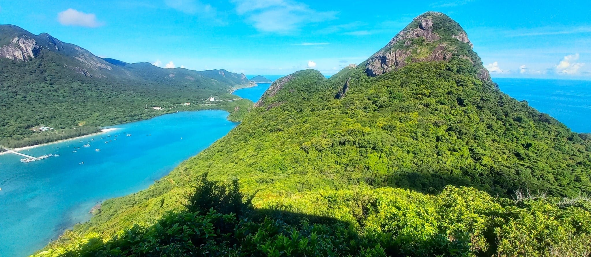
For sensational views, the Love Peak hike offers the greatest effort to reward ratio of all the Côn Đảo trails. The hike is short and steep, but the vistas are spectacular. The trailhead is on Hòn Bà, a rugged and green island in the south of the Côn Đảo archipelago. Getting to Hòn Bà requires a short, scenic boat crossing from Bến Đàm port. Little green boats cluster at the start of the port’s pier. You’ll be approached by boat drivers. Ask for Hòn Bà and bargain the price. Although I’m sure you can get much cheaper, I paid 200,000vnđ ($8) for the return crossing. This includes waiting time: either arrange a time in advance to be picked up on the island or take the driver’s phone number and call when you’re ready. The crossing is beautiful, although sadly trash is starting to taint this blue bay.
On Hòn Bà, the boat moors at a wooden pier on a sandy beach. Walk to the western end of the beach and you’ll see the trailhead leading up to a national park ranger station. There are two trails: both are clearly signposted. Bear left behind the ranger station to start the ascent to Đỉnh Tình Yêu (Love Peak). The trail is paved and stepped and easy to follow. The climb is steep and very humid beneath the thick jungle canopy. However, it only takes between 45-60 minutes to reach the lookout tower at the top. The views down over the bay, across the entire archipelago are breathtaking. It’s very peaceful. Everything is vivid green and blue. A breeze cools the air. Given the option, I’d happily camp up here.
Coming down can be tricky because the gradient is steep and the steps are always damp as the sunlight doesn’t penetrate to the forest floor. Walk carefully. Back at the bottom, take the path on the other side of the ranger station, signposted to Đầm Quốc. This leads along level ground through big trees and along the edges of an inlet before rising sharply and then descending to a rocky bay with a couple of buildings. Bathing here is OK, but it’s probably better to save your swim for the sandy beach back at the wooden pier where the boat dropped you.
IMAGES: Love Peak Hike


Trail 3: Bamboo Lagoon
HIKE DETAILS:
- Route: Bãi Vông beach→Airport→Đầm Tre Lagoon
- Map: green line on my map [MAP]
- Location: north-west, Côn Sơn Island
- Scenery: beaches, jungle, streams, wildlife, bays, lagoons, swimming, snorkeling, SUP
- Duration: 4-6 hours round-trip
- Difficulty: moderate
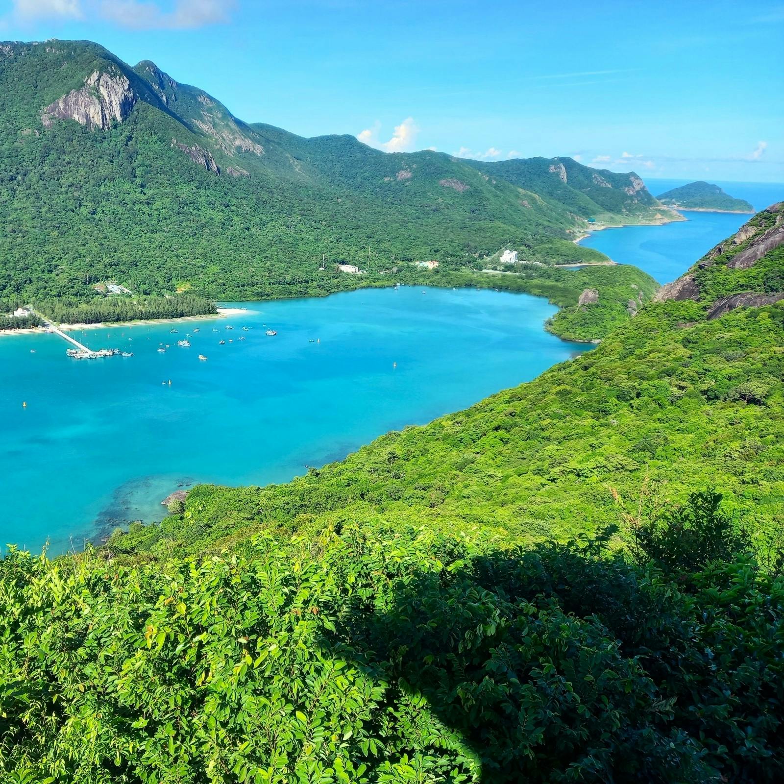
At the remote, wind-swept and wave-lashed northern tip of Côn Sơn Island, a slab of rugged land arches east into the sea, creating a protected circular lagoon of turquoise water where coral and fish flourish and visitors rarely venture. Mangroves rim the bay and the hills around it are covered in bamboo, hence the name Đầm Tre – Bamboo Lagoon. This part of the island has remained undeveloped and in its glorious natural state precisely because it’s hard to get to. The hike starts on the long, wide, empty sands of Bãi Vông beach. You can access the beach wherever you like, but the easiest way is to take the path off the main road at the southern end of the beach, or continue on the road to about halfway along the bay and you’ll see a pathway signposted to the beach to the east. The walk along the beach is deceptively long. At the northern end, if the tide is in, you’ll need to walk along the wall at the end of the island’s airport runway.
When reaching the northern end of the beach, the trailhead begins across a small stream and heads up into the jungle and hills via a steep, paved pathway. The hike is surprisingly tiring because the atmosphere is incredibly close beneath all the foliage. Streams rush over boulders by the pathway, inviting you to cool off. Eventually, the foliage thins and the path meets a national park ranger station on the edge of Đầm Tre Bay. It’s a wonderful spot. The rangers can arrange boat rides around the lagoon, including snorkeling in the middle of the bay where there’s some excellent coral. SUP boards are available to rent. The swimming is great. Directly across the lagoon from the ranger station pier is ‘Secret Beach‘, a spit of sand backed by jungle with an Instagram-ready wooden swing poking out of the shallows. The beach is only accessible by boat or, if you’re confident, swimming. There are showers at the ranger station, but what’s the point when you still have the humid return walk ahead of you! Allow at least half a day for the round-trip hike and activities at the lagoon. (See Patrick’s Dam Tre Bay Guide for more information.)
IMAGES: Bamboo Lagoon Hike


Trail 4: Bang Beach
HIKE DETAILS:
- Route: National Park HQ→Đức Mẹ grotto→Bãi Bàng beach→Đất Thắm beach
- Map: blue line on my map [MAP]
- Location: centre-west, Côn Sơn Island
- Scenery: jungle, grottoes, rocky beaches, waterfalls, streams, wildlife, swimming
- Duration: 3-4 hours round-trip
- Difficulty: moderate
Starting from the well-signposted trailhead just north of the National Park HQ, the trail to Bàng beach is peaceful, easy to follow and passes through the dense jungle of Côn Sơn Island’s remote western flank. Early in the hike there’s an optional detour to Đức Mẹ grotto, a Catholic shrine to the Virgin Mary in a small but atmospheric jungle cave. The pathway to Bàng beach is pleasant and green. Although the canopy is too dense to see out of, you can hear the sea through the trees and even smell its salty scent in the humid air. The jungle is impressively gnarled and twisted. Many of the trees are giant and old with thick, buttressed trunks. A couple of streams and pools provide welcome opportunities to wash and cool down.
After quite a sweaty hike, the pathway splits at a signposted junction. Take the western branch and descend steeply to Bãi Bàng (Bang beach), a rocky and secluded coastline that’s fairly unremarkable except for a dramatic waterfall crashing down a wall of vertical rock straight onto the beach at the southern end. Back up at the junction, take the eastern branch to continue through the jungle to Đất Thắm beach, a pretty, crescent bay of sand and pebbles between two jungle-clad headlands. There’s a national park ranger station here, but nothing else. If the tide is in, the swimming and snorkeling are good.
IMAGES: Bang Beach Hike


Trail 5: God Mountain
HIKE DETAILS:
- Route: National Park HQ→Núi Chúa mountain→Hoàng Tử shrine→Đầm Trầu beach
- Map: orange line on my map [MAP]
- Location: central Côn Sơn Island
- Scenery: jungle, streams, mountains, beaches, wildlife, shrines
- Duration: 3-5 hours one-way
- Difficulty: moderate-difficult
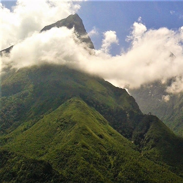
The longest one-way hike on the island, there are two trailheads for the Núi Chúa (God Mountain) route: one at the northern end not far from Đầm Trầu beach, which is well signposted, and the other at the southern end near the National Park HQ, which isn’t. You could hike from either direction, but perhaps it makes most sense to go from south to north, beginning at the National Park HQ and ending at Đầm Trầu, so that you can enjoy a swim and refreshments at the beach after the long and sweaty hike. The trailhead is on the opposite side of the road from Ma Thiên Lãnh bridge, accessed by walking behind the public toilets, up into the brush until it opens to an intersection of pathways: try to stay as straight and to your right as you can and eventually you’ll find your way onto a well-paved pathway.
This hike features a long ascent and descent, both of which can be quite difficult, because the pathway has been blocked in many places by fallen trees and undergrowth, and because the steps can become very slippery as they’re covered in damp moss. The route takes you along the spine of Côn Sơn Island, high up into the jungles and hills in the middle of the island. Although it’s an atmospheric trek beneath the trees, there aren’t any excellent viewpoints. After descending to the northern trailhead, continue on to Đầm Trầu beach by turning right onto the road, then immediately left onto Cỏ Ống street and left again at the signpost for the beach. On the road to Đầm Trầu there’s a shrine to Hoàng Tử Cải, a boy prince who’s part of Côn Đảo’s history and mythology. Finally, at the beach get some refreshments from the beach shacks and stroll to the western end of the sand to take a small path through the trees and over to the next bay – Suối Nóng – which is an even nicer beach than Đầm Trầu.
IMAGES: God Mountain Hike


Other Walks:
As well as the established hiking trails, Côn Sơn Island is a very walkable destination in general. The quiet, tree-lined back-streets of Côn Sơn town are ideal for strolling. But it’s the long, elegant seafront road (Tôn Đức Thắng street) that steals the show. Shaded by century-old tropical almond trees, the road sweeps along the seafront from the national park office to Lò Vôi beach. You can swim at any point along the road; the views over the bay are fabulous; and several French-era villas crumble beneath the trees.
In fact, you could hike the island’s coast road in its entirely: from the airport in the north to Bến Đầm port in the south. However, the quietest section of road is the newly laid west coast route, running from the National Park HQ south to Bến Đầm port. There’s hardly any traffic, the jungle is broken only by the road itself, there are countless opportunities to crawl down the rocks to find a good swimming spot, monkeys often play in the road, and the sunsets are terrific.
IMAGES: Other walks on Côn Sơn Island


*Disclosure: I never receive payment for anything I write: my content is always free and independent. I’ve written this guide because I want to: I like these hikes and I want my readers to know about them. For more details, see my Disclosure & Disclaimer statements and my About Page


Just wanted to thank and congratulate you on a very thorough and helpful article. I am on Con Dao atm, about to start a little hike and this article will be my bible. Thanks!
Thanks, Zoe. I hope you have fun doing some of the hikes on the islands.
Best,
Tom
Hey hey, anyone up for trekking in Con Dao? I’m planning to explore Con Dao for a whole month! Hit me up!!
I did the Love Peak hike on Con Dao over a week ago and had a talk with a forest ranger at the station on Hòn Bà island regarding foreigners who want to do this specific hike independently. Apparently, the local green boats that Tom mentioned in the guide (I also took one last time from Bến Đầm port for VND100k/return trip) do not meet the safety standards for transporting passengers especially foreigners, and if they are caught to do so, they will get a fine. That’s the reason why some foreign travellers get rejected by these boat drivers (as a local, I also got rejected by the first 2 boat drivers before the 3rd one took me on). If you are lucky or if you travel with a local person, you might be able to get the crossing with one of the green boats just fine. However, the forest ranger on Hòn Bà told me that as foreign visitor(s) you are advised to book one of the speed boat tours to get to Hòn Bà island and this could be pricey as Karl mentioned below unless you travel in a big group to share the cost. Alternatively, if you travel alone or in a small group, you can also utilise the free pickup/drop-off service provided by one of the floating restaurants nearby as you book a lunch/dinner with them (depending if you do the morning or afternoon hike) – they can pick you up at Bến Đầm port and you can ask them to drop you off at the pier of Hòn Bà for your hike and arrange the time with them so that they can come back to pick you up from the pier to their restaurant for the meal that you booked in advance. The closest floating restaurant to the pier on Hòn Bà is nhà hàng nổi Sang Côn Đảo (Sang Con Dao floating restaurant).
Hope this helps.
Thao
Hi Thao,
Thank you for this very helpful update.
It is good to have more clarity about the situation for foreigners who want to do this hike.
It seems a shame that foreign visitors can’t charter one of the small green boats as this is an inexpensive, fast and easy way to get to the trailhead and it contributes to the local economy. I hope that the local authorities will change their minds about this in the near future so that more people can enjoy this beautiful hike without having to pay the high expense of a speedboat service or the inconvenience of having to go via the floating restaurant.
Best,
Tom
Hi, the situation remains somehow strange. The other information seem to be true. They want you to take an expensive tour from the main port otherwise the fisherman get fined. However locals are without much asking taken to the other side to “have fun and drink” there. I was lucky enough to join a group at the right time after having no success trying it on my own. The Hon Ba island itself is stunning and there was nobody when I climbed the Love Peak. Sure, the garbage is also existent on the shores, but it’s definitely not as bad as on the other side of the main island where all the oily sticky plastic piles up at the beaches. The ecosystem is clearly in danger there and I also heard rumors in town that they even want to build a casino on Hon Ba. Not sure if true or not, but seems like there was recently brought an undersea power supply from the mainland to Con Dao to boost construction projects. In fact most of the beaches on the West Side are already closed beacuse of some fugly Ressort Project construction going on or about to start soon. I had a great time exploring the island but a bitter taste is left behind. I highly doubt that it would be the same experience in a few years and I can only imagine what paradise it might have been about ten years ago.
Hi Jason,
Thanks for sharing your experience. I’m glad you enjoyed it on Hon Ba.
I’ve also just returned from the Con Dao Islands and although there are certainly signs of environmental damage and trash, it is still remarkably clean, especially compared to almost all other coastal regions in Vietnam. Yes, it was fantastic 10-15 years ago, but it still is today in my opinion. Inevitably there will be more and more resort construction on the islands and more and more people will visit, so things are bound to change. But, for now at least, Con Dao remains one of the best, if not THE best, natural environments of any tourist destination in Vietnam.
Best,
Tom
Hi Tom
Thanks for the blog. My family and I returned from Vietnam this morning (18/04/2023). We spent 5 nights on Con Dao and went there mainly for the hiking and snorkelling. As an update, the Love Peak walk is no longer accessible via the green fishing boats at Ben Dam port. When we explained to the tour operator at the port what we wanted to do, we were taken to the green fishing boats , but while we were in the process of organising a price with the driver, we were stopped by a border guard and told we were not allowed go to Ben Ha island. With the help of an English speaking local and google translate, the reason we were given was we were foreign tourists. The GM of the Hotel we were staying at contacted an island official for an explanation and was told for foreign tourists to get to the island, you have to go into town and get on a ferry or a private tour. We were quoted 4million VND for 4 people to go to the island for 3 hours on a private tour, so we opted for one of the other walks.
Thanks
Karl
Hi Karl,
I’m sorry to hear that. That’s very strange – I just did the Love Peak hike again 2 days ago and had no problem at all. I was with all foreign travellers, we took the boat from the port across to the island as described in this guide, paid the national park entrance fee at the kiosk on the island (50,000vnd) and did the hike. I think (I hope) you just got very unlucky. I’m sure at this moment, not many foreign visitors do the Love Peak hike and the official you were dealing with just didn’t know the ‘rules’. Anyway, thank you for sharing your experience.
Best,
Tom